Drachenfels (Central Palatinate Forest)

Last updated
Drachenfels

DrachenfelsPfalz.JPG

The Westfelsen rocks in winter
Highest point
Elevation 570.8 m above  sea level (NHN) (1,873 ft) [1]
Prominence 261 m  Hochspeyer [2]
Isolation 11.6 km
Coordinates 49°25′30″N8°03′11″E / 49.425°N 8.05306°E / 49.425; 8.05306 Coordinates: 49°25′30″N8°03′11″E / 49.425°N 8.05306°E / 49.425; 8.05306
Geography
Parent range Palatine Forest
Geology
Mountain type Bunter sandstone
Climbing
Access 1873 [3]
(Remnants of a Roman fortification)

The Drachenfels ("Dragon Rock") is a hill in the northern part of the Palatine Forest in the German state of Rhineland-Palatinate) on the forest estate of the county town of Bad Dürkheim. At 570.8 m above  sea level (NHN) [1] , it is the highest point of the Palatine Forest north of the Hochspeyerbach - Speyerbach line. The Drachenfels area has been designated as a nature reserve.

Rhineland-Palatinate State in Germany

Rhineland-Palatinate is a state of Germany.

Bad Dürkheim Place in Rhineland-Palatinate, Germany

Bad Dürkheim is a spa town in the Rhine-Neckar urban agglomeration, and is the seat of the Bad Dürkheim district in Rhineland-Palatinate, Germany.

<i>Normalhöhennull</i> standard reference level, the equivalent of sea level, used in Germany to measure height

Normalhöhennull or NHN is a vertical datum used in Germany.

Contents

Geography

Location

The hill lies in the west of a triangle whose sides are about 14 kilometres long, formed by the Isenach valley (B 37) in the north, the German Wine Route in the east and the valleys of the Hochspeyerbach and Speyerbach streams (B 39) in the southwest.

Isenach left tributary of the Rhine

The Isenach is a left tributary of the Rhine in the northeastern Palatine region of Rhineland-Palatinate. It is nearly 36 kilometres (22 mi) long.

German Wine Route

The German Wine Route or Wine Road is the oldest of Germany's tourist wine routes. Located in the Palatinate region of the federal state of Rhineland-Palatinate, the route was established in 1935.

Hochspeyerbach river in Germany

The Hochspeyerbach is a 21 km (13 mi) long river in the Palatinate forest in Rhineland-Palatinate and a left tributary of the Speyerbach.

Surrounding area

Other tourist destinations in the area of the Drachenfels include the Siegfriedsbrunnen spring, the unoccupied forester's lodge of Kehrdichannichts, the ruins of the Murrmirnichtviel and Schaudichnichtum forester's lodges, the Lambertskreuz cross, first recorded in 1280 and the oldest wayside cross in the Palatinate region, the managed Lambertskreuz Hut, the Saupferch forest inn and the leisure and wildlife park of, the Kurpfalz Park.

Kehrdichannichts Lodge

Kehrdichannichts Lodge is a former hunting lodge in the Palatine Forest west of Bad Dürkheim in the German state of Rhineland-Palatinate. It belonged to the Leiningen counts.

Wayside cross cross by a footpath, track or road

A wayside cross is a cross by a footpath, track or road, at an intersection, along the edge of a field or in a forest. It can be made of wood, stone or metal. Most wayside crosses are designed as crucifixes. Stone crosses may also be conciliation crosses. Often they serve as waymarks for walkers and pilgrims or designate dangerous places. They are particularly common in Europe, for example in Germany, Galicia, Ireland and the Alps.

Description

The summit plateau, made of Bunter sandstone and about 13 hectares in area, which, from the Rhine Plain is clearly higher than the hills in front of it, has its highest point in the northeast. It was made a nature reserve in 1972. Until 1920, a pair of short-toed snake eagles nested here.

The Upper Rhine Plain, Rhine Rift Valley or Upper Rhine Graben is a major rift, about 350-kilometre-long (220 mi) and on average 50-kilometre-wide (31 mi), between Basel in the south and the cities of Frankfurt/Wiesbaden in the north. Its southern section straddles the border between France and Germany. It forms part of the European Cenozoic Rift System, which extends across central Europe. The Upper Rhine Graben formed during the Oligocene as a response to the evolution of the Alps to the south and remains active to the present day. Today, the Rhine Rift Valley forms a downfaulted trough through which the river Rhine flows.

Nature reserve protected area for flora, fauna or features of geological interest

A nature reserve is a protected area of importance for flora, fauna or features of geological or other special interest, which is reserved and managed for conservation and to provide special opportunities for study or research. Nature reserves may be designated by government institutions in some countries, or by private landowners, such as charities and research institutions, regardless of nationality. Nature reserves fall into different IUCN categories depending on the level of protection afforded by local laws. Normally it is more strictly protected than a nature park.

Short-toed snake eagle species of bird

The short-toed snake eagle, also known as short-toed eagle, is a medium-sized bird of prey in the family Accipitridae, which also includes many other diurnal raptors such as kites, buzzards and harriers. The genus name Circaetus is from the Ancient Greek kirkos, a type of hawk, and aetos, "eagle". The specific gallicus means "of Gaul".

The name of the hill is – like that of the nearby Siegfriedsbrunnen spring – connected with the dragon from the Nibelung legend. [3] Below the rock that juts out far to the southwest there are two caves; the small one is called the "Dragon's Chamber" (Drachenkammer), the larger one, the "Dragon's Lair" (Drachenhöhle). In the west of the plateau the remnants of a fortification from Roman times have survived; the former circular rampart is only just recognizable under the vegetation. From the so-called "West Rocks" (Westfelsen) in the northwest may be seen the Donnersberg, the summit of the Hunsrück range, to the north, and the city of Kaiserslautern to the west.

Dragon a large, serpent-like legendary creature that appears in the folklore of many cultures around the world

A dragon is a large, serpent-like legendary creature that appears in the folklore of many cultures around the world. Beliefs about dragons vary drastically by region, but dragons in western cultures since the High Middle Ages have often been depicted as winged, horned, four-legged, and capable of breathing fire. Dragons in eastern cultures are usually depicted as wingless, four-legged, serpentine creatures with above-average intelligence.

The term Nibelung (German) or Niflung is a personal or clan name with several competing and contradictory uses in Germanic heroic legend. It has an unclear etymology, but is often connected to the root nebel, meaning mist. The term in its various meanings gives its name to the Middle High German heroic epic the Nibelungenlied.

Circular rampart An embankment built in the shape of a circle

A circular rampart is an embankment built in the shape of a circle that was used as part of the defences for a military fortification, hill fort or refuge, or was built for religious purposes or as a place of gathering.

Tourism

Transport

Hiking trail on the Drachenfels (2005) GermanyPfalzDrachenfels.jpg
Hiking trail on the Drachenfels (2005)

Due to its central location Drachenfels accessible from all sides, albeit only on foot because the area is protected. Mountain bikes or other wheeled vehicles are not allowed. The ascent is very steep and runs over woodland tracks and paths that are unsurfaced in places. The nearest hiker's car park, Forsthaus Saupferch, where there is a trail map erected by the Palatine Forest Club, may be reached from the north – from the B 37 Kaiserslautern to Bad Dürkheim road – over a roughly 2 kilometre-long, metalled road.

Maintenance

The Drachenfels area is maintained by the Drachenfels Club. [3] The club, whose aim is the preservation and care of heritage sites in and around Bad Dürkheim, was founded in 1873 and opened up the Drachenfels to visitors that same year. [4]

Related Research Articles

Kaiserslautern (district) District in Rhineland-Palatinate, Germany

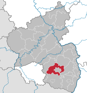
Kaiserslautern is a district (Kreis) in the south of Rhineland-Palatinate, Germany. Neighboring districts are Kusel, Saarpfalz-Kreis, Donnersbergkreis, Bad Dürkheim and Südwestpfalz. The city of Kaiserslautern is almost fully enclosed by, but not belonging to the district.

Palatinate Forest low mountain range in Germany

The Palatinate Forest, sometimes also called the Palatine Forest, is a low-mountain region in southwestern Germany, located in the Palatinate in the state of Rhineland-Palatinate. The forest is a designated nature park covering 1,771 km2 and its highest elevation is the Kalmit.

Neidenfels Place in Rhineland-Palatinate, Germany

Neidenfels is an Ortsgemeinde – a municipality belonging to a Verbandsgemeinde, a kind of collective municipality – in the Bad Dürkheim district in Rhineland-Palatinate, Germany.

Drachenfels Castle (Wasgau) castle ruin in Rhineland-Palatinate, Germany

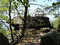
Drachenfels Castle is a ruined hill castle near the village of Busenberg in the state of Rhineland-Palatinate. It lies within the German half of the Wasgau region, the southern part of the Palatinate Forest.

Battenberg Castle castle

Battenberg Castle is a castle ruin near Battenberg in the county of Bad Dürkheim in the state of Rhineland-Palatinate, Germany.

North Palatine Uplands mountains in Germany

The North Palatine Uplands, sometimes incorrectly shortened to Palatine Uplands, is a low mountain range and landscape unit in the German state of Rhineland-Palatinate and belongs mainly to the Palatinate region. It is part of the Saar-Nahe Uplands.

Palatinate Forest Nature Park nature park in Rhineland-Palatinate, Germany

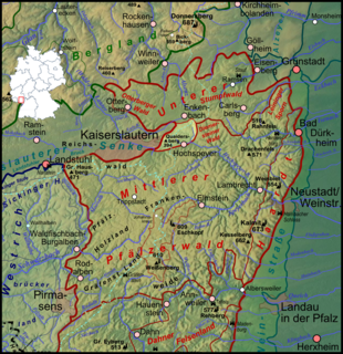
The Palatinate Forest Nature Park lies in the south of Rhineland-Palatinate in Germany and borders on France. The nature park covers an area of 177,100 hectares (684 sq mi) and some 76% of its area is under the woods of the Palatinate Forest, the largest contiguous forest region in Germany. Together with a part of northern Alsace it forms the Palatinate Forest-North Vosges Biosphere Reserve and has an impressive Bunter sandstone landscape.

Dahner Felsenland

The Dahner Felsenland, also referred to as the Dahn Rockland, is a landscape in the county of Südwestpfalz in the German federal state of Rhineland-Palatinate. It is located in the middle section of the Wasgau, which in turn forms the southern part of the Palatine Forest and the northern part of the Vosges in France. The Dahner Felsenland has numerous rock formations within the South Palatinate Climbing Area.

Wasgau mountain range

The Wasgau is a Franco-German hill range in the German state of Rhineland-Palatinate and the French departments of Bas-Rhin and Moselle. It is formed from the southern part of the Palatine Forest and the northern part of the Vosges mountains, and extends from the River Queich in the north over the French border to the Col de Saverne in the south.

Diemerstein Forest forest

Diemerstein Forest is a part of the Palatine Forest, a mountainous region within the German state of Rhineland-Palatinate. It has an area of about 50 km².

Frankenweide

The Frankenweide is a hill region in the German state of Rhineland-Palatinate. It forms the central part of the Palatine Forest in the Palatinate region.

Hoher Stoppelkopf mountain

The Hohe Stoppelkopf, locally just called the Stoppelkopf, is a 566.2-metre-high hill in the Palatine Forest in the German state of Rhineland-Palatinate. It lies 3 km north of the small town of Lambrecht.

Eschkopf German hill

The Eschkopf near Hofstätten in the German state of Rhineland-Palatinate is a major hill, 608.3 m above sea level (NHN) high in the Palatine Forest.

Kesselberg (Haardt) mountain

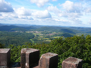
The Kesselberg near Edenkoben in the German state of Rhineland-Palatinate is a mountain, 661.8 m above sea level (NHN), It iis second highest peak in the Palatine Forest region after the Kalmit and also the third highest mountain in the Palatinate region.

Schindhübel

The Schindhübel is a hill, 571 m above sea level (NN), that rises in the middle of the Palatine Forest in Germany, 5 kilometres southwest of Elmstein.

Walking routes in the Palatine Forest

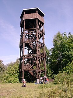
Walking routes in the Palatine Forest fall into two categories. The first are longer walking routes, most of which are maintained by the Palatine Forest Club, or PWV, and which are linked to the national and international network of long distance paths. The second category are those local circular walks and themed walking routes, some of which are of wider regional importance, and which are maintained by municipal authorities. The Palatine Forest, as part of the Palatine Forest-North Vosges Biosphere Reserve, is an important conservation area. As a result, the Palatine Forest, the bunter sandstone landscape of the Palatine Forest Nature Park, the castles in the Dahner Felsenland and the cross-border paths into Alsace and the Vosges make the region particularly popular with ramblers and walkers.

Bismarck Tower (Kallstadt)

The Bismarck Tower on the 497-metre-high Peterskopf in the Haardt mountains on the eastern edge of the Palatine Forest stands within an exclave of the municipality of Kallstadt in the German state of Rhineland-Palatinate.

Peterskopf (Haardt) mountain

The Peterskopf, near the Palatine county town of Bad Dürkheim in the German state of Rhineland-Palatinate, is a 487-metre-high hill in the Haardt mountains. On its summit is the Bismarck tower.

Queitersberg mountain

The Queitersberg, more rarely spelt Quaidersberg, Quaitersberg or Queidersberg, is a 394-metre-high hill in the northern Palatine Forest in the German state of Rhineland-Palatinate. On a subpeak is the natural monument of the Felsplatt, a rock formation.

References