| Dravinjski Vrh | |
|---|---|
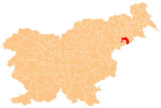
 Dravinjski Vrh Location in Slovenia | |
| Coordinates: 46°21′43.78″N15°54′11.11″E / 46.3621611°N 15.9030861°E Coordinates: 46°21′43.78″N15°54′11.11″E / 46.3621611°N 15.9030861°E | |
| Country | |
| Traditional region | Styria |
| Statistical region | Drava |
| Municipality | Videm |
| Area | |
| • Total | 2.65 km2 (1.02 sq mi) |
| Elevation | 305.4 m (1,002.0 ft) |
| Population (2002) | |
| • Total | 272 |
| [1] | |
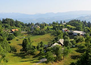
Dravinjski Vrh (pronounced [dɾaˈʋiːnski ˈʋəɾx] ) is a settlement on the right bank of the Dravinja River in the Municipality of Videm in eastern Slovenia. The area traditionally belonged to the Styria region. It is now included in the Drava Statistical Region. [2]

The Dravinja is the largest tributary of the Drava River in Slovenia. It is 73 kilometres (45 mi) long. Its source is on the Pohorje Massif southwest of Mount Rogla about 1,150 m above sea level. The river passes Zreče, the town of Slovenske Konjice, the ruins of the fort at Zbelovo, Poljčane, Makole, Štatenberg Castle, Majšperk, and Videm pri Ptuju, where it merges with the Drava. Its main tributary is the river Polskava.
The Municipality of Videm is a municipality in Slovenia. It includes part of the flatlands south of Ptuj and extends beyond the Dravinja River into the Haloze Hills to the south. The area traditionally belonged to the region of Styria. It is now included in the Drava Statistical Region. The administrative centre of the municipality is the settlement of Videm pri Ptuju.

Slovenia, officially the Republic of Slovenia, is a sovereign state located in southern Central Europe at a crossroads of important European cultural and trade routes. It is bordered by Italy to the west, Austria to the north, Hungary to the northeast, Croatia to the southeast, and the Adriatic Sea to the southwest. It covers 20,273 square kilometers (7,827 sq mi) and has a population of 2.07 million. One of the successor states of the former Yugoslavia, Slovenia is a parliamentary republic and a member of the United Nations, of the European Union, and of NATO. The capital and largest city is Ljubljana.
The local church is dedicated to John the Baptist and was originally the chapel of Traun (Dranek) Castle. It dates to the 12th and 13th centuries and is a typical Romanesque church with a rectangular nave, a lower sanctuary, and a simple belfry next to its northern side. [3] The foundations of Dranek Castle are barely visible. It was a castle built in the 12th century, mentioned in written sources dating to 1147 and was demolished by Ottoman raiders in 1532. [4]

A church building or church house, often simply called a church, is a building used for Christian religious activities, particularly for Christian worship services. The term is often used by Christians to refer to the physical buildings where they worship, but it is sometimes used to refer to buildings of other religions. In traditional Christian architecture, the church is often arranged in the shape of a Christian cross. When viewed from plan view the longest part of a cross is represented by the aisle and the junction of the cross is located at the altar area.

John the Baptist was a Jewish itinerant preacher in the early first century AD. John is revered as a major religious figure in Christianity, Islam, the Bahá'í Faith, and Mandaeism. He is called a prophet by all of these faiths, and is honored as a saint in many Christian traditions. Other titles for John include John the Forerunner in Eastern Christianity and "the prophet John (Yaḥyā)" in Islam. To clarify the meaning of "Baptist", he is sometimes alternatively called John the Baptizer.

Romanesque architecture is an architectural style of medieval Europe characterized by semi-circular arches. There is no consensus for the beginning date of the Romanesque style, with proposals ranging from the 6th to the 11th century, this later date being the most commonly held. In the 12th century it developed into the Gothic style, marked by pointed arches. Examples of Romanesque architecture can be found across the continent, making it the first pan-European architectural style since Imperial Roman architecture. The Romanesque style in England is traditionally referred to as Norman architecture.