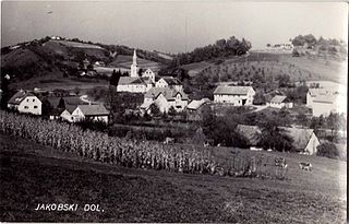
Spodnji Leskovec

Last updated
Spodnji Leskovec
Slovenia location map.svg
Red pog.svg
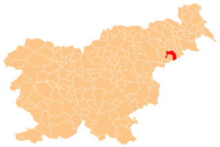
Spodnji Leskovec
Location in Slovenia
Coordinates: 46°20′12.33″N15°56′25.69″E / 46.3367583°N 15.9404694°E / 46.3367583; 15.9404694 Coordinates: 46°20′12.33″N15°56′25.69″E / 46.3367583°N 15.9404694°E / 46.3367583; 15.9404694
Country Flag of Slovenia.svg Slovenia
Traditional region Styria
Statistical region Drava
Municipality Videm
Area
  Total 1.86 km2 (0.72 sq mi)
Elevation 219.9 m (721.5 ft)
Population (2002)
  Total 115
[1]

Spodnji Leskovec (pronounced  [ˈspoːdnji ˈleːskɔʋəts] ) is a settlement in the valley of Lipnica Creek, a minor tributary of the Drava River in the Haloze Hills in eastern Slovenia. It is part of the Municipality of Videm. The area traditionally belonged to the Styria region. It is now included in the Drava Statistical Region. [2]

Drava river in Italy, Austria, Slovenia, Croatia and Hungary

The Drava or Drave is a river in southern Central Europe. With a length of 710 kilometres (440 mi), 724 kilometres (450 mi) including the Sextner Bach source, it is the fifth or sixth longest tributary of the Danube, after the Tisza, Sava, Prut, Mureș and perhaps Siret. Its source is near the market town of Innichen, in the Puster Valley of South Tyrol, Italy. The river flows eastwards through East Tirol and Carinthia in Austria into the Styria region of Slovenia. It then turns southeast, passing through Croatia and, after merging with its main tributary Mur, forms most of the border between Croatia and Hungary, before it joins the Danube near Osijek.

Haloze

Haloze is a geographical sub-region of Slovenia. It is in the northeast of the country, in the Styria region.

Slovenia republic in Central Europe

Slovenia, officially the Republic of Slovenia, is a sovereign state located in southern Central Europe at a crossroads of important European cultural and trade routes. It is bordered by Italy to the west, Austria to the north, Hungary to the northeast, Croatia to the southeast, and the Adriatic Sea to the southwest. It covers 20,273 square kilometers (7,827 sq mi) and has a population of 2.07 million. One of the successor states of the former Yugoslavia, Slovenia is a parliamentary republic and a member of the United Nations, of the European Union, and of NATO. The capital and largest city is Ljubljana.

There is a small rectangular chapel-shrine with a polygonal apse in the settlement. It was built in 1909. [3]

Wayside shrine religious image, usually in some sort of small shelter, placed by a road or pathway

A wayside shrine is a religious image, usually in some sort of small shelter, placed by a road or pathway, sometimes in a settlement or at a crossroads, but often in the middle of an empty stretch of country road, or at the top of a hill or mountain. They have been a feature of many cultures, including Catholic and Orthodox Europe and Shinto Japan.

Apse Semicircular recess covered with a hemispherical vault or semi-dome

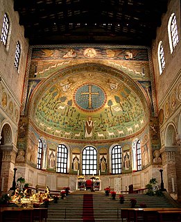
In architecture, an apse is a semicircular recess covered with a hemispherical vault or semi-dome, also known as an exedra. In Byzantine, Romanesque, and Gothic Christian church architecture, the term is applied to a semi-circular or polygonal termination of the main building at the liturgical east end, regardless of the shape of the roof, which may be flat, sloping, domed, or hemispherical. Smaller apses may also be in other locations, especially shrines.

Related Research Articles

Municipality of Videm Municipality in Slovenia

The Municipality of Videm is a municipality in Slovenia. It includes part of the flatlands south of Ptuj and extends beyond the Dravinja River into the Haloze Hills to the south. The area traditionally belonged to the region of Styria. It is now included in the Drava Statistical Region. The administrative centre of the municipality is the settlement of Videm pri Ptuju.

Spodnji Velovlek Place in Styria, Slovenia

Spodnji Velovlek is a settlement on the right bank of the Pesnica River in the City Municipality of Ptuj in northeastern Slovenia. The area is part of the traditional region of Styria. It is now included with the rest of the municipality in the Drava Statistical Region.

Spodnji Ključarovci in Styria, Slovenia

Spodnji Ključarovci is a settlement in the Slovene Hills northwest of Ormož in northeastern Slovenia. The area traditionally belonged to the region of Styria. It is now included in the Drava Statistical Region.

Dravci in Styria, Slovenia

Dravci is a settlement on the right bank of the Drava River at its confluence with the Dravinja in the Municipality of Videm in eastern Slovenia. The area traditionally belonged to the Styria region. It is now included in the Drava Statistical Region.

Gradišče, Videm in Styria, Slovenia

Gradišče is a settlement in the Haloze Hills in the Municipality of Videm in eastern Slovenia, next to the border with Croatia. The area traditionally belonged to the Styria region. It is now included in the Drava Statistical Region.

Lancova Vas in Styria, Slovenia

Lancova Vas is a settlement on the left bank of the Polskava River in the Municipality of Videm in eastern Slovenia. The area traditionally belonged to the Styria region. It is now included in the Drava Statistical Region.

Majski Vrh in Styria, Slovenia

Majski Vrh is a settlement in the Haloze Hills above the right bank of the Dravinja River in the Municipality of Videm in eastern Slovenia. The area traditionally belonged to the Styria region. It is now included in the Drava Statistical Region.

Pobrežje, Videm in Styria, Slovenia

Pobrežje is a settlement south of Ptuj in the Municipality of Videm in eastern Slovenia. The area traditionally belonged to the Styria region. It is now included in the Drava Statistical Region.

Skorišnjak in Styria, Slovenia

Skorišnjak is a settlement in the Haloze Hills in eastern Slovenia, close to the border with Croatia. It belongs to the Municipality of Videm. The area traditionally belonged to the Styria region. It is now included in the Drava Statistical Region.

Soviče in Styria, Slovenia

Soviče is a settlement in the Haloze Hills above the right bank of the Drava River in eastern Slovenia. It belongs to the Municipality of Videm. The area traditionally belonged to the Styria region. It is now included in the Drava Statistical Region.

Šturmovci in Styria, Slovenia

Šturmovci is a settlement in the Municipality of Videm in eastern Slovenia. It lies south of Lake Ptuj. The area traditionally belonged to the Styria region. It is now included in the Drava Statistical Region.

Trdobojci in Styria, Slovenia

Trdobojci is a settlement in the Haloze Hills in the Municipality of Videm in eastern Slovenia. The area traditionally belonged to the Styria region. It is now included in the Drava Statistical Region. It includes the hamlets of Spodnji Trdobojci and Zgornji Trdobojci.

Trnovec, Videm in Styria, Slovenia

Trnovec is a settlement on the left bank of the Polskava River in the Municipality of Videm in eastern Slovenia. The area traditionally belonged to the Styria region. It is now included in the Drava Statistical Region.

Tržec in Styria, Slovenia

Tržec is a settlement at the confluence of the Polskava River with the Dravinja in the Municipality of Videm in eastern Slovenia. The area traditionally belonged to the Styria region. It is now included in the Drava Statistical Region.

Veliki Okič in Styria, Slovenia

Veliki Okič is a settlement in the Haloze Hills in eastern Slovenia. It lies close to the border with Croatia in the Municipality of Videm. The area traditionally belonged to the Styria region. It is now included in the Drava Statistical Region.

Zgornji Leskovec Village in Styria, Slovenia

Zgornji Leskovec is a settlement in the upper valley of Lipnica Creek, a minor tributary of the Drava River, in the Municipality of Videm in eastern Slovenia. The area traditionally belonged to the Styria region. It is now included in the Drava Statistical Region.

Leskovec, Slovenska Bistrica in Styria, Slovenia

Leskovec is a dispersed settlement in the Pohorje Hills in the Municipality of Slovenska Bistrica in northeastern Slovenia. It lies on the local road from Stari Log to Spodnja Nova Vas, southwest of Pragersko. The area is part of the traditional region of Styria. It is now included with the rest of the municipality in the Drava Statistical Region.

Spodnji Gaj pri Pragerskem in Styria, Slovenia

Spodnji Gaj pri Pragerskem is a small settlement just east of Pragersko in northeastern Slovenia. It belongs to the Municipality of Kidričevo. The area is part of the traditional region of Styria. It is now included with the rest of the municipality in the Drava Statistical Region.

Spodnji Jakobski Dol in Styria, Slovenia

Spodnji Jakobski Dol is a settlement in the Municipality of Pesnica in northeastern Slovenia. It lies in the Slovene Hills, part of the traditional region of Styria. The municipality is now included in the Drava Statistical Region.

Spodnji Duplek in Styria, Slovenia

Spodnji Duplek is a settlement and the administrative centre of the Municipality of Duplek in northeastern Slovenia. It lies on the left bank of the Drava River southeast of Maribor. The area is part of the traditional region of Styria. The municipality is now included in the Drava Statistical Region.

References