The Dresden Heath (German: Dresdner Heide) is a large forest in the city of Dresden, Germany. The heath is the most important recreation area in the city and is also actively forested. Approximately 6,133 hectares of the Dresden Heath are designated as a nature preserve, making it one of the largest municipal forests in Germany by area. Though mainly agricultural areas border the forest in the east, in all other directions the Dresden Heath is bordered by districts of the city and reaches nearly to the city centre in the southwest.
The forest exhibits a transition, both in its geology and in its plant and animal life, between the North German Plain and the Central Uplands. Except for small areas, the Dresden Heath is considered part of the western Lusatian Highlands and, consequently, is one of the westernmost parts of the Sudetes. Though the rocky subsoil of the forest was raised during the tectonic formation of the Dresden Basin, the mixed woodland of the heath is largely characterized by dune-like sand deposits of the Wolstonian Stage and Elster glaciation. The proximity of the Dresden Heath to the centre of Dresden led to its use as a princely hunting ground, as well as its cultivation and cultural development.
Location
Located in the northeast of the Saxon capital, the main part of the heath stretches from the city centre to the border of Dresden. The forest is mainly outside the urban area of Dresden and is largely in the administrative region of Loschwitz. In contrast to the other parts of this administrative area, the 4,836 hectare region is not considered an urban district, but forms a fully-fledged district of the same status. Smaller regions on the edge of the heath belong to the administrative districts of Neustadt and Klotzsche, as well as to the town of Radeburg. In the south, the main part of the heath stretches between Loschwitz and the Waldschlösschen district, to the slopes of the Elbe and to Radeberger Vorstadt. The southernmost offshoots even border on the heavily populated Äussere Neustadt. In the west, the forest meets Albertstadt and Klotzsche. In the north, it is bordered by the Weixdorf districts of Lausa and Friedersdorf as well as by Langebrück and Liegau-Augustusbad. In the east the forest is bordered by the town of Radeberg and its districts of Großerkmannsdorf and Ullersdorf.
The Junge Heide ("Young Heath"), the smaller part, is to the west of the main part of the heath in the northwest of Dresden. It is bordered in the north by the districts of Wilschdorf and Hellerau, in the east by the Heller and in the south by Trachenberge and Trachau. In the west the Junge Heide meets the Radebeuler districts of Oberlößnitz and Alt-Radebeul, in the northwest, Boxdorf. The part of the Junge Heide in the districts of Hellerberge and Wilschdorf belongs to the administrative district of Klotzsche. The western part of the Junge Heide, on the other hand, is assigned to Trachau. Together with a small area on the edge of the heath in the south that belongs to Trachenberge, it is in the administrative district of Pieschen. Further areas in the west of the Junge Heide are administered from Moritzburg or Radebeul.
Surrounding landscapes include Lößnitz in the West, the Friedewald and the Moritzburg pond region in the northwest. In the north, the Königsbrück-Ruhland Heaths and the Seifersdorf valley border the forest in the northeast. The landscape to the southeast is the Schönfeld Upland. On the southern border of the Heide, the forest segues into the park and garden landscape of the Dresden Elbe valley.
History of the Forest
Originally, the Dresden Heath was part of the expansive, continuous border forest between the Sorbian regions of Nisan and Milska. It was out of this forest that the Mark of Meißen and Upper Lusatia developed. Originally, the Dresden Heath began in the city centre of Dresden and stretched seamlessly to the Lößnitz as well as to Kaditz, in the form of the Kaditz Forest. Archaeological discoveries, such as the Bronze Ageburial grounds and late Stone AgeCorded Warepottery give evidence of early settlements in this area. The settlement of the region reduced the area of the forest with time. As part of the German eastward settlement in the twelfth and thirteenth centuries, efforts to clear the forest reduced it to something close to its current size, though the Dresden Heath still stretched into the centre of Dresden, and the Junge Heide was not yet a separate forest.
After 1372, the Dresden Heath was sovereign property assigned to the office of Radeberg, servicing the court of Saxony as a vast hunting territory from the Middle Ages to the First World War. The court in Dresden could 'hunt' its way from Dresden to the hunting retreat, Moritzburg Castle. Evidence of the heath's hunting history are the four so-called Saugärten ('Swine gardens,' used in the hunt to hold captured wild boar, until it could be released to be hunted). Farmers have also used parts of the heath, such as the two meadows, for agriculture. In the light, sandy soil, agriculture did not last long and fields were often actively reforested or reclaimed by the forest itself. From 1484, the heath was administered by the Dresden Forest Office. The forest was heavily damaged in the Thirty Years' War as enemy troops burned parts of the forest and plundered surrounding villages. The Seven Years' War also brought great losses of wood to the Prussian occupiers. In 1831 the heath became a possession of the Saxon State but remained hunting grounds of the sovereign.
In the beginning of the nineteenth century the heath had an area of over 70 square kilometres, roughly fifty percent more than now. It still reached in the city centre across the Bischofsweg. The Förstereistraße ('Forestry Street') in Neustadt is named after a forester's lodge that existed there near the forest. Then the heath was reduced by 10 square kilometres for military reasons. Large areas were deforested after 1827 to create a training ground for the Saxon army, resulting in the existence of the Heller. After 1873 barracks were constructed in the new military district in Albertstadt, significantly reducing the southwestern area of the heath. Adjacent areas of the forest were also inaccessible because they were behind firing ranges. In the late nineteenth century, the former suburbs of Dresden began to grow. The Radeberger Vorstadt (city suburb in the direction of Radeberg) stretched further and further into the forest. Within a few years, people pushed the heath back out of the city centre by two kilometres. Klotzsche also grew into a city, in part at the expense of the forest. In Radebeul-Ost, Bad Weißer Hirsch, Klotzsche-Königswald and the Radeberger Vorstadt more of the heath was converted into 'forest parks.' At the beginning of the twentieth century, the responsible authorities required compensatory plantings to counter smaller clearings of the heath. This resulted in the planting of a small forest near Biegau in 1910.
The Dresden Heath and Junge Heide became separated due to the development of transport corridors such as Radeburger and Königsbrücker Streets as well as the Saxon-Silesian railway and, finally, the present A4 motorway. In the Third Reich, planned highway construction affected the northeast part of the forest. The plan was for a continuation of the present Autobahn 13, resulting in a Berlin-Dresden-Prague connection. Some of the deforestation between Radeberg and Heidemühle was completed, but construction did not begin in the Second World War. The plans were later discarded and, in 2000, the same connection was built but with a completely different route and without affecting the heath in any way. In the 1930s there were plans for a continuation of the now-decommissioned rail line between Dürröhrsdorf and Weißig, along the Prießnitz valley across the heath. This, too, remained in the planning stage and, since then, the forest has not been reduced by large construction projects.
Since its incorporation into the city on the fourth of March, 1949, the Dresden Heath belongs to Dresden. Declared a special forest and recreation area in 1967, it has been a protected landscape since 1969. Due to forestry however, almost no area of the heath can be considered old growth forest. There are still inaccessible parts of the heath, a result of the former military use or of the construction of transportation buildings.
Radebeul is a town in the Elbe valley in the district of Meißen in Saxony, Germany, a suburb of Dresden. It is well known for its viticulture, a museum dedicated to writer Karl May, and a narrow gauge railway connecting Radebeul with the castle of Moritzburg and the town of Radeburg. The Meißen area, where Radebeul is located, is one of the northeasternmost areas where wine is grown in the 21st century.
Moritzburg is a municipality in the district of Meissen in Saxony, Germany, between Meissen itself, an early centre of Saxony, and today's capital Dresden. It is most famous for its Baroque castle, Schloss Moritzburg.
Radeberg is a small town in the district of Bautzen, Saxony, Germany. It is located approximately 20 kilometres north-east of Dresden. The town has an Evangelical and a Roman Catholic church, and an old castle.
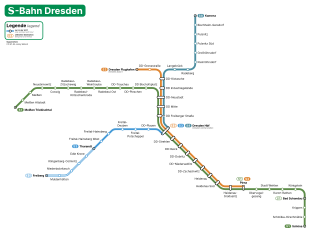
The Dresden S-Bahn is a network of S-Bahn-type commuter train services in Dresden and the surrounding area. It is commissioned by Verkehrsverbund Oberelbe (VVO) from DB Regio Verkehrsbetrieb Südostsachsen and currently consists of three services operating over a 127.7 km-long (79.3 mi) network.
Dresden is a cultural centre in Germany which has influenced the development of European culture. "It is [...] outstanding as a cultural landscape, an ensemble that integrates the celebrated Baroque setting and suburban garden city into an artistic whole within the river valley, and as an example of land use, representing an exceptional development of a major Central-European city."
Dresden is a large city in the eastern Saxony nearby the border to the Czech Republic at the river Elbe. The geography and urban development of Dresden is embossed by the valley location and by the Elbe stream.
Schilling & Graebner was an architecture firm based in Dresden, Germany, founded by the architects Rudolf Schilling (1859–1933) and Julius Graebner (1858–1917) in 1889. The firm was under their direction from 1889 until Graebner's death, but continued to exist until 1947, most notably under Graebner's son Erwin (1895–1945). The firm, which initially devoted itself primarily to historicism and later to Art Nouveau and early modernism, worked on mainly buildings in Saxony, including several noteworthy churches, Dresden villas, administrative buildings and entire residential districts. One of the firms' most important works is the Christuskirche in Dresden (1903–1905), which arguably marks the transition of sacral architecture in Germany from historicism to modernity.
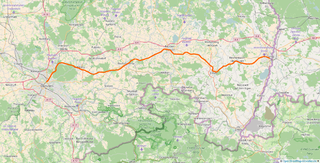
The Görlitz–Dresden railway is a two-track main line railway in the German state of Saxony, originally built and operated by the Saxon-Silesian Railway Company. It runs through Upper Lusatia from Dresden via Bischofswerda, Bautzen and Löbau to Görlitz. The line is part of the route from Dresden to Wrocław and Pan-European Transport Corridor III. The first section of the line opened in 1845 and it is one of the oldest lines in Germany.
The Albertstadt is a neighborhood of Dresden, Germany. It was named after Albert of Saxony, who initiated the construction of this suburb. At that time it was the largest garrison in Germany.
Klotzsche is a borough (Stadtbezirk) of Dresden, Germany. It consists of four quarters (Stadtteile):
Werte der deutschen Heimat originally Werte der Deutschen Heimat and, between 1970 and 1990 called Werte unserer Heimat, was a series of publications by former East German Academy of Sciences at Berlin, that was published by Akademie-Verlag Berlin and included more than 50 volumes. The work was undertaken by the Academy’s Local History Working Group within the Institute for Geography and Geo-ecology.
The Saxon Elbeland is a term used in more recent times which describes a region along the Elbe, whose boundaries are not clearly defined, but which extends roughly from the Elbe Sandstone Mountains to Torgau. The best-known cities and town in this area are Dresden, Meißen, Riesa and Torgau. The term is largely synonymous with the region along the river known as the Upper Elbe (Oberelbe), i.e. the German section of the Elbe River nearest its source region.
Dresden-Klotzsche station is a railway station in the town of Klotzsche, Saxony, Germany. The station lies on the Görlitz–Dresden railway, Dresden-Klotzsche–Königsbrück railway and Dresden-Klotzsche–Dresden Flughafen railway.
The West Lusatian Hill Country and Uplands, sometimes just the West Lusatian Hills, is a natural region in Saxony. It is divided into the West Lusatian Foothills in the east and the Lusatian Plateau in the west and forms the westernmost extremity of the Sudetes range.
The classification of natural regions of Saxony shown here was produced between 1994 and 2001 by a working group called "Ecosystem and Regional Character" at the Saxonian Academy of Sciences in Leipzig as part of the research and development project "Natural Regions and Natural Region Potential of the Free State of Saxony" at a scale of 1:50,000 as the basis for the rural development and regional planning. This was also supported by the Saxon State Ministry of the Environment and Agriculture and the Saxon Ministry of the Interior.
The Radebeul-Kötzschenbroda station is in Kötzschenbroda, a district of Radebeul in the German state of Saxony. It is classified by Deutsche Bahn as a Haltepunkt. It is located on the Pirna–Coswig railway, which was recently created as a separate line as part of the upgrade of the Leipzig–Dresden railway. The station, which was previous called Radebeul West, was rebuilt and renamed Radebeul-Kötzschenbroda in 2013 and it is now served mainly by the Dresden S-Bahn.
Radebeul-Weintraube station is in Radebeul in the German state of Saxony. It is classified by Deutsche Bahn as a Haltepunkt. Weintraube station was opened in 1838 in the Lößnitz fields as the first station out of Dresden on Germany's oldest long-distance railway, the Leipzig–Dresden railway. It is now the oldest station still regularly served in Saxony.
Radebeul Ost (east) station is a station in the Große Kreisstadt of Radebeul in the German state of Saxony. It is in the suburb now called Radebeul-Ost. The station buildings are located within the boundaries of Alt-Radebeul on Sidonienstraße. The station is on the Dresden S-Bahn network.
Gottfried Kluttig was a German Kantor and Kirchenmusikdirektor.
This page is based on this Wikipedia article Text is available under the CC BY-SA 4.0 license; additional terms may apply. Images, videos and audio are available under their respective licenses.