
The Sierra Ancha is a mountain range in Gila County, in central Arizona. It lies between Roosevelt Lake to the south, the Tonto Basin to the west, Cherry Creek to the east, and Pleasant Valley to the north. The range is one of several, including the Bradshaw Mountains, Mingus Mountain of the Black Hills, and the Mazatzal Mountains, which form a transitional zone between the lowland deserts of southern Arizona and the Colorado Plateau of northeastern Arizona. The highest point in the range is Aztec Peak, at an elevation of 2345 m (7694 ft).

The Tonto Group is a name for an assemblage of related sedimentary strata, collectively known by geologists as a Group, that comprises the basal sequence Paleozoic strata exposed in the sides of the Grand Canyon. As currently defined, the Tonto groups consists of the Sixtymile Formation, Tapeats Sandstone, Bright Angel Shale, Muav Limestone, and Frenchman Mountain Dolostone. Historically, it included only the Tapeats Sandstone, Bright Angel Shale, and Muav Limestone. Because these units are defined by lithology and three of them interfinger and intergrade laterally, they lack the simple layer cake geology as they are typically portrayed as having and geological mapping of them is complicated.
Except where underlain by the Sixtymile Formation, the Tapeats Sandstone is the Cambrian geologic formation that is the basal geologic unit of the Tonto Group. Typically, it is also the basal geologic formation of the Phanerozoic strata exposed in the Grand Canyon, Arizona, and parts of northern Arizona, central Arizona, southeast California, southern Nevada, and southeast Utah. The Tapeats Sandstone is about 230 feet (70 m) thick, at its maximum. The lower and middle sandstone beds of the Tapeats Sandstone are well-cemented, resistant to erosion, and form brownish, vertical cliffs that rise above the underlying Precambrian strata outcropping within Granite Gorge. They form the edge of the Tonto Platform. The upper beds of the Tapeats Sandstone form the surface of the Tonto Platform. The overlying soft shales and siltstones of the Bright Angel Shale underlie drab-greenish slopes that rise from the Tonto Platform to cliffs formed by limestones of the Muav Limestone and dolomites of the Frenchman Mountain Dolostone.
The Cardenas Basalt, also known as either the Cardenas Lava or Cardenas Lavas, is a rock formation that outcrops over an area of about 310 km2 (120 mi2) in the eastern Grand Canyon, Coconino County, Arizona. The lower part of the Cardenas Basalt forms granular talus slopes. Its upper part forms nearly continuous low cliffs that are parallel to the general course of the Colorado River. The most complete, readily accessible, and easily studied exposure of the Cardenas Basalt lies in Basalt Canyon. This is also its type locality.

The Unkar Group is a sequence of strata of Proterozoic age that are subdivided into five geologic formations and exposed within the Grand Canyon, Arizona, Southwestern United States. The 5-unit Unkar Group is the basal member of the 8-member Grand Canyon Supergroup. The Unkar is about 1,600 to 2,200 m thick and composed, in ascending order, of the Bass Formation, Hakatai Shale, Shinumo Quartzite, Dox Formation, and Cardenas Basalt. Units 4 & 5 are found mostly in the eastern region of Grand Canyon. Units 1 through 3 are found in central Grand Canyon. The Unkar Group accumulated approximately between 1250 and 1104 Ma. In ascending order, the Unkar Group is overlain by the Nankoweap Formation, about 113 to 150 m thick; the Chuar Group, about 1,900 m (6,200 ft) thick; and the Sixtymile Formation, about 60 m (200 ft) thick. These are all of the units of the Grand Canyon Supergroup. The Unkar Group makes up approximately half of the thickness of the 8-unit Supergroup.

The Middle Permian Toroweap Formation is a thin, darker geologic unit, between the brighter colored units of the Kaibab Limestone above, and Coconino Sandstone below. It is a prominent unit in Grand Canyon, Arizona, USA, found through sections of the South Rim, Grand Canyon, and the North Rim, of the Kaibab Plateau; also the Kaibab's southeast extension to Cape Royal, the Walhalla Plateau. The Colorado River of the Grand Canyon makes its excursion from due-south to due-west around the Walhalla Plateau, as it enters the east end of the Grand Canyon's interior, Granite Gorge. The formation is also found in southeast Utah.

Isis Temple is a prominence in the Grand Canyon, Arizona, Southwestern United States. It is located below the North Rim and adjacent to the Granite Gorge along the Colorado River. The Trinity Creek and canyon flow due south at its west border; its north, and northeast border/flank is formed by Phantom Creek and canyon, a west tributary of Bright Angel Creek; the creeks intersect about 3 mi (4.8 km) southeast, and 1.0 mi (1.6 km) north of Granite Gorge. The Isis Temple prominence, is only about 202 ft (62 m) lower than Grand Canyon Village, the main public center on Grand Canyon’s South Rim.

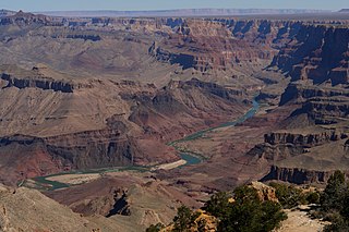
The Grand Canyon Supergroup is a Mesoproterozoic to a Neoproterozoic sequence of sedimentary strata, partially exposed in the eastern Grand Canyon of Arizona. This group comprises the Unkar Group, Nankoweap Formation, Chuar Group and the Sixtymile Formation, which overlie Vishnu Basement Rocks. Several notable landmarks of the Grand Canyon, such as the Isis Temple and Cheops Pyramid, and the Apollo Temple, are surface manifestations of the Grand Canyon Supergroup.

Located directly downstream of the Little Colorado River confluence with the Colorado River, the Tanner Graben, in the Grand Canyon, Arizona, US is a prominence and cliffside rock formation below the East Rim. Tanner Graben is located riverside, on the Colorado River, on a north-northwest bank at Mile 68.5, and lies opposite Tanner Canyon. The Tanner Rapid, created by Tanner Creek lies at the riverside foot of the graben. The graben is a pronounced feature because of the black Cardenas Basalt that forms the middle section of the graben, presumably free of debris accumulation by its cliff face steepness, and winds, and airflow drainage that course through the Colorado River's canyons; unprotected side canyons of Cardenas Basalt show accumulations as a slope-forming geologic unit, with little showing of black basalt.
The Hakatai Shale is a Mesoproterozoic rock formation with important exposures in the Grand Canyon, Coconino County, Arizona. It consists of colorful strata that exhibit colors varying from purple to red to brilliant orange. These colors are the result of the oxidation of iron-bearing minerals in the Hakatai Shale. It consists of lower and middle members that consist of bright-red, slope-forming, highly fractured, argillaceous mudstones and shale and an upper member composed of purple and red, cliff-forming, medium-grained sandstone. Its thickness, which apparently increases eastwards, varies from 137 to 300 m. In general, the Hakatai Shale and associated strata of the Unkar Group rocks dip northeast (10–30°) toward normal faults that dip 60° or more toward the southwest. This can be seen at the Palisades fault in the eastern part of the main Unkar Group outcrop area. In addition, thick, prominent, and dark-colored basaltic sills and dikes cut across the purple to red to brilliant orange strata of the Hakatai Shale.

The Lower Permian Esplanade Sandstone is a cliff-forming, resistant sandstone, dark red, geologic unit found in the Grand Canyon. The rock unit forms a resistant shelf in the west Grand Canyon, south side of the Colorado River, at the east of the Toroweap Fault, down-dropped to west, southeast of Toroweap Overlook, and west of Havasupai. The red, sandstone shelf, The Esplanade is about 20-mi long. At Toroweap Overlook region, Toroweap Valley with Vulcan's Throne, Uinkaret volcanic field, the resistant Esplanade Sandstone is described in access routes exploring the Toroweap Lake area.

The (Upper) Late Pennsylvanian Wescogame Formation is a slope-forming, sandstone, red-orange geologic unit, formed from an addition of eolian sand, added to marine transgression deposits,, and found throughout sections of the Grand Canyon, in Arizona, Southwest United States. It is one of the upper members of the Supai Group 'redbeds', with the Supai Group found in other sections of Arizona, especially in the Verde Valley region, or as a basement unit below the Mogollon Rim, just eastwards or part of the basement Supai Group of the southwest & south Colorado Plateau.

The Bass Formation, also known as the Bass Limestone, is a Mesoproterozoic rock formation that outcrops in the eastern Grand Canyon, Coconino County, Arizona. The Bass Formation erodes as either cliffs or stair-stepped cliffs. In the case of the stair-stepped topography, resistant dolomite layers form risers and argillite layers form steep treads. In general, the Bass Formation in the Grand Canyon region and associated strata of the Unkar Group-rocks dip northeast (10°–30°) toward normal faults that dip 60+° toward the southwest. This can be seen at the Palisades fault in the eastern part of the main Unkar Group outcrop area. In addition, thick, prominent, and dark-colored basaltic sills intrude across the Bass Formation.
The Shinumo Quartzite also known as the Shinumo Sandstone, is a Mesoproterozoic rock formation, which outcrops in the eastern Grand Canyon, Coconino County, Arizona,. It is the 3rd member of the 5-unit Unkar Group. The Shinumo Quartzite consists of a series of massive, cliff-forming sandstones and sedimentary quartzites. Its cliffs contrast sharply with the stair-stepped topography of typically brightly-colored strata of the underlying slope-forming Hakatai Shale. Overlying the Shinumo, dark green to black, fissile, slope-forming shales of the Dox Formation create a well-defined notch. It and other formations of the Unkar Group occur as isolated fault-bound remnants along the main stem of the Colorado River and its tributaries in Grand Canyon.
Typically, the Shinumo Quartzite and associated strata of the Unkar Group dip northeast (10°–30°) toward normal faults that dip 60+° toward the southwest. This can be seen at the Palisades fault in the eastern part of the main Unkar Group outcrop area.
The Supai Group is a slope-forming section of red bed deposits found in the Colorado Plateau. The group was laid down during the Pennsylvanian to Lower Permian. Cliff-forming interbeds of sandstone are noticeable throughout the group. The Supai Group is especially exposed throughout the Grand Canyon in northwest Arizona, as well as local regions of southwest Utah, such as the Virgin River valley region. It occurs in Arizona at Chino Point, Sycamore Canyon, and famously at Sedona as parts of Oak Creek Canyon. In the Sedona region, it is overlain by the Hermit Formation, and the colorful Schnebly Hill Formation.

The Shinarump Conglomerate is a geologic formation found in the Four Corners region of the United States. It was deposited in the early part of the Late Triassic period.
The Neoproterozoic Chuar Group consists of 5,250 feet (1,600 m) of fossiliferous, unmetamorphosed sedimentary strata that is composed of about 85% mudrock. The Group is the approximate upper half of the Grand Canyon Supergroup, overlain by the thin, in comparison, Sixtymile Formation, the top member of the multi-membered Grand Canyon Supergroup.

The Sixtymile Formation is a very thin accumulation of sandstone, siltstone, and breccia underlying the Tapeats Sandstone that is exposed in only four places in the Chuar Valley. These exposures occur atop Nankoweap Butte and within Awatubi and Sixtymile Canyons in the eastern Grand Canyon, Arizona. The maximum preserved thickness of the Sixtymile Formation is about 60 meters (200 ft). The actual depositional thickness of the Sixtymile Formation is unknown owing to erosion prior to deposition of the Tapeats Sandstone.
The Apache Group is a Mesoproterozoic group of geologic formations in the southwestern United States.

The Mazatzal Group is a group of geologic formations that crops out in portions of central Arizona, US. Detrital zircon geochronology establishes a maximum age for the formation of 1660 to 1630 million years (Mya), in the Statherian period of the Precambrian. The group gives its name to the Mazatzal orogeny, a mountain-building event that took place between 1695 and 1630 Mya.
