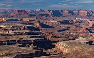
Canyonlands National Park is a national park of the United States located in southeastern Utah near the town of Moab. The park preserves a colorful landscape eroded into numerous canyons, mesas, and buttes by the Colorado River, the Green River, and their respective tributaries. Legislation creating the park was signed into law by President Lyndon B. Johnson on September 12, 1964.
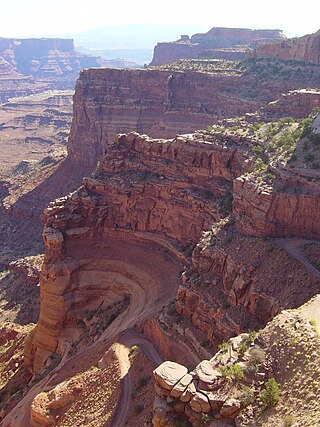
The geology of the park is the consequence of deposition, uplift and erosion. Island in the Sky is a mesa overlooking the Green River to the west and the Colorado River to the east, and separated from the Colorado Plateau by "the neck". From the top of the mesa to the Honaker Trail Formation at the canyon river bottom, 150 million years of geologic stratum is exposed. Upheaval Dome consists of the Chinle Formation in the center and the Navajo Sandstone along the rim. The Cedar Mesa Sandstone comprised the Needles District. Canyons comprise the Maze District.

The Cutler Formation or Cutler Group is a rock unit that is exposed across the U.S. states of Arizona, northwest New Mexico, southeast Utah and southwest Colorado. It was laid down in the Early Permian during the Wolfcampian epoch.

Cedar Mesa Sandstone is a sandstone member of the Cutler Formation, found in southeast Utah, southwest Colorado, northwest New Mexico, and northeast Arizona.

Mesa Arch is a pothole arch on the eastern edge of the Island in the Sky mesa in Canyonlands National Park in northern San Juan County, Utah, United States. Mesa Arch is a spectacular natural stone arch perched at the edge of a cliff with vast views of canyons, Monster Tower, Washer Woman Arch, Airport Tower, and the La Sal Mountains in the distance. Access is via a relatively easy hiking trail, just a half-mile long from the park road.

The White Rim Sandstone is a sandstone geologic formation located in southeastern Utah. It is the last member of the Permian Cutler Group, and overlies the major Organ Rock Formation and Cedar Mesa Sandstone; and again overlies thinner units of the Elephant Canyon and Halgaito Formations.

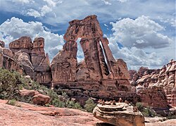
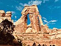
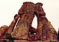
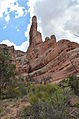
Angel Arch is the largest natural arch located within Canyonlands National Park, in San Juan County, Utah. Some consider it the most beautiful and spectacular arch in the park, if not the entire canyon country. It is situated in a side canyon of Salt Creek Canyon, in the Needles District of the park. Precipitation runoff from Angel Arch drains north into the nearby Colorado River via Salt Creek. A 29-mile round-trip hike to Angel Arch leads to a viewpoint, and an additional 0.75-mile trail scrambles up into the arch opening. The arch's descriptive name comes from its resemblance to an angel with wings folded, and standing with its back to the arch opening. Before this feature's name was officially adopted in 1963 by the U.S. Board on Geographic Names, it was called Pegasus Arch. The first ascent was made in June 1993, by John Markel and Kevin Chase.

Monster Tower is a 600-foot (180-meter) tall sandstone tower located in the Island in the Sky District of Canyonlands National Park, in San Juan County, Utah, United States.
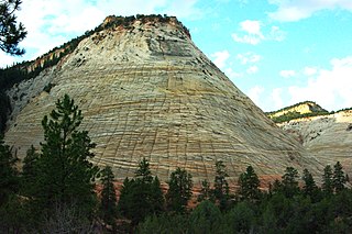
Checkerboard Mesa is an iconic 6,520+ ft elevation Navajo Sandstone summit located in Zion National Park, in Kane County of southwest Utah, United States. Checkerboard Mesa is situated immediately southwest of the park's east entrance, towering 900 feet above the Zion – Mount Carmel Highway. Its nearest neighbor is Crazy Quilt Mesa, one-half mile immediately west, and separated by Checkerboard Mesa Canyon. This canyon holds pools of rainwater which provide a vital source of water for resident bighorn sheep. This peak was originally named Checkerboard Mountain by the park's third superintendent, Preston P. Patraw. The landform's toponym was officially adopted in 1935 by the U.S. Board on Geographic Names. The descriptive name stems from the cliff's distinctive multitudinous check lines in cross-bedded white sandstone which give the impression of a checkerboard. The horizontal lines are caused by cross-bedding, a remnant of ancient sand dunes. The vertical and sub-vertical lines formed by the contraction and expansion of the sandstone caused by temperature changes, freezing and thawing cycles, in combination with wetting and drying. Precipitation runoff from this mountain drains into tributaries of the Virgin River.

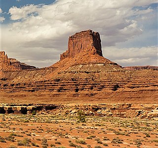
Washer Woman is a 500-foot (150-meter) tall sandstone arch and tower located in the Island in the Sky District of Canyonlands National Park, in San Juan County, Utah. It is situated 300 feet northwest of the slightly higher Monster Tower. Washer Woman is so named because the feature gives the appearance of a washerwoman bent over a washtub. This geographical feature's name was officially adopted in 1986 by the U.S. Board on Geographic Names after previously having similar names such as Washer-Woman Arch and The Washer Woman. Washer Woman and Monster Tower are an eroded fin composed of Wingate Sandstone, which is the remains of wind-borne sand dunes deposited approximately 200 million years ago in the Late Triassic. Airport Tower is set 1.6 mi (2.6 km) to the east, and Mesa Arch is situated 1.5 mi (2.4 km) to the west. A short hike to Mesa Arch provides the easiest view of Washer Woman. Access to this formation is via the four-wheel drive White Rim Road, which is the other option to see it. The top of this geological formation rises 1,300 feet above the road in approximately one mile. Precipitation runoff from Washer Woman drains southeast into the nearby Colorado River via Buck Canyon.
Airport Tower is a 700-foot (210-meter) tall sandstone butte located in the Island in the Sky District of Canyonlands National Park, in San Juan County, Utah. It is situated 1.64 mile east of Washer Woman, which is a towering arch similar in height. Each are composed of Wingate Sandstone, which is the remains of wind-borne sand dunes deposited approximately 200 million years ago in the Late Triassic. The nearest higher neighbor is Monster Tower, 1.6 mi (2.6 km) to the west, Tiki Tower is one-half mile northwest, and Mesa Arch is situated 3.2 mi (5.1 km) to the west. A short hike to Mesa Arch provides the easiest view of Airport Tower. Access to this tower is via the four-wheel drive White Rim Road, which is another option to see Airport Tower. The top of this geological formation rises 1,400 feet above the road in less than one mile. Precipitation runoff from Airport Tower drains southeast into the nearby Colorado River via Buck and Lathrop Canyons. This geographical feature's name was officially adopted in 1986 by the U.S. Board on Geographic Names. It was so named because the rock formation resembles the appearance of an airport control tower.

Zeus and Moses are a pair of 500-foot-tall (150 m) sandstone formations located in the Island in the Sky District of Canyonlands National Park, in San Juan County, Utah, United States. These rock towers' names refer to Zeus, a god in Greek mythology, and Moses, an important prophet in several religious traditions. Zeus and Moses are composed of Wingate Sandstone, which is the remains of wind-borne sand dunes deposited approximately 200 million years ago in the Late Triassic. This formation is situated in Taylor Canyon, 3 mi (4.8 km) north-northeast of Upheaval Dome. Access to the towers is via the four-wheel-drive White Rim Road, and a spur road into Taylor Canyon. The top of this geological formation rises 900 feet above the canyon floor at road's end, approximately one-half mile away. Precipitation runoff from Zeus and Moses drains into the nearby Green River via Taylor Canyon.

Aztec Butte is a sandstone summit, elevation 6,312 feet, located in the Island in the Sky District of Canyonlands National Park, in San Juan County, Utah. Aztec Butte is composed of white cross-bedded Navajo Sandstone, which is the remains of wind-borne sand dunes deposited approximately 170 million years ago during the Jurassic Period. It resembles the Pyramid of the Sun in Mexico, which was built by the Aztecs.

Crazy Quilt Mesa is a 6,760 ft (2,060 m) elevation white Navajo Sandstone summit located in Zion National Park, in Kane County of southwest Utah, United States.

Buttes of the Cross is two sandstone summits located in the northern reach of Glen Canyon National Recreation Area, in Wayne County of Utah, United States. The larger and higher south butte reaches an elevation of 5,642 feet, whereas the north butte rises to 5,569 feet, with approximately 0.6 miles (0.97 km) separation between them. When viewed from the north-northeast near Labyrinth Canyon, they align to form the shape of a cross, creating the appearance of a single butte. The name "Butte of the Cross" was first applied by John Wesley Powell during the Powell Geographic Expedition of 1869. A few miles further down the Green River, Powell finds that this geographical feature is two buttes when viewed from the east, so it was renamed Buttes of the Cross. Buttes of the Cross towers over 1,400 feet above its surrounding terrain. It is situated 6.8 miles west of Candlestick Tower, and one-half mile outside the boundary of Canyonlands National Park.

Junction Butte is a 6,400-foot-elevation (2,000-meter) summit located in the Island in the Sky District of Canyonlands National Park, in San Juan County, Utah. It is set about one mile south of the southern tip of Island in the Sky. A short hike to Grand View Point provides a view of Junction Butte. Access to this butte is via the four-wheel drive White Rim Road, which is another option to view Junction Butte. Topographic relief is significant as the top of this geological formation rises 1,400 feet above the road in less than one mile. Precipitation runoff from Junction Butte drains east into the nearby Colorado River, and west into nearby Green River. Junction Butte is situated north of the junction of these two major rivers.

The Sixshooter Peaks are two iconic sandstone summits located in Bears Ears National Monument in San Juan County, Utah, United States. The larger and higher North Sixshooter Peak rises to an elevation of 6,379 feet, whereas South Sixshooter Peak rises to 6,154 feet, with approximately 1.5 miles (2.4 km) separation between the two. These buttes tower nearly 1,400 feet above the surrounding terrain, and are historic landmarks visible from State Route 211 between Newspaper Rock and the Needles District of Canyonlands National Park. They are situated 1.5 mile outside the boundary of the park, and four miles northwest of Bridger Jack Butte. Variant names for the peaks include "North Six-Shooter Peak", "South Six-shooter Peak", "Six Shooter Peaks", and "Six-shooter Peak". They are so named because of their resemblance to a pair of revolvers pointing skyward.

Bridger Jack Butte is a sandstone butte located in Bears Ears National Monument, in San Juan County, Utah, United States. Set at the northern tip of Bridger Jack Mesa and above the confluence of Indian and Lavender Creeks, the summit rises to an elevation of 5,890 feet, and towers over 700 feet above the surrounding terrain and floor of Lavender Canyon to its west. This landmark is situated four miles southeast of the Sixshooter Peaks, and is visible from State Route 211 between Newspaper Rock and the Needles District of Canyonlands National Park. "Bridger Jack" was a Paiute medicine man.

Eagle Crags is a 6,380-foot (1,940 m) elevation summit located in the Canaan Mountain Wilderness of Washington County in southwest Utah, United States.

Outlaw Spire, also known as "Hardscrabble Spire," is a sandstone pillar located within Canyonlands National Park, in San Juan County, Utah, United States. It is situated in the Island in the Sky District of the park at the top of Hardscrabble Hill at the western tip of Bighorn Mesa. This landform is composed of Wingate Sandstone, which is the remains of wind-borne sand dunes deposited approximately 200 million years ago in the Late Triassic. Precipitation runoff from Outlaw Spire drains into the nearby Green River which is 1,000 feet below, and less than one-quarter mile away from the tower in Labyrinth Canyon. Access is via the White Rim Road which skirts beneath this remote spire.