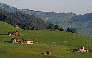
Zagorje ob Savi is a town in the Central Sava Valley in central Slovenia. It is the seat of the Municipality of Zagorje ob Savi. It is located in the valley of Medija Creek, a minor left tributary of the Sava River, 52 km (32 mi) east of Ljubljana 36 km (22 mi) southwest of Celje, and 6 km (4 mi) west of Trbovlje. Traditionally the area was part of the Upper Carniola region. The entire municipality is now included in the Central Sava Statistical Region. The town is home to about 7,000 people. It includes the hamlets of Toplice and Podvine.

Borje is a small settlement north of Šentlambert in the Municipality of Zagorje ob Savi in central Slovenia. The area was traditionally part of the Upper Carniola region. It is now included with the rest of the municipality in the Central Sava Statistical Region.

Dolenja Vas is a settlement in the Municipality of Zagorje ob Savi in central Slovenia. It extends from the western outskirts of Zagorje ob Savi to the left bank of the Sava River. The area is part of the traditional region of Upper Carniola. It is now included with the rest of the municipality in the Central Sava Statistical Region.

Jesenovo is a settlement north of Zagorje ob Savi in central Slovenia. The area is part of the traditional region of Upper Carniola. It is now included with the rest of the Municipality of Zagorje ob Savi in the Central Sava Statistical Region.

Mošenik is a settlement on the left bank of the Sava River in the Municipality of Zagorje ob Savi in central Slovenia. The railway line from Ljubljana to Zidani Most runs through the settlement. The area is part of the traditional region of Upper Carniola. It is now included with the rest of the municipality in the Central Sava Statistical Region.
Polšina is a small settlement southeast of Trojane in central Slovenia. It belongs to the Municipality of Zagorje ob Savi. The area is part of the traditional region of Upper Carniola. It is now included with the rest of the municipality in the Central Sava Statistical Region.
Požarje is a settlement in the hills above the left bank of the Sava River, southeast of Šentlambert in the Municipality of Zagorje ob Savi in central Slovenia. The area is part of the traditional region of Upper Carniola. It is now included with the rest of the municipality in the Central Sava Statistical Region.
Prapreče is a settlement north of Zagorje ob Savi in central Slovenia. Traditionally the area was part of the Upper Carniola region. It is now included with the rest of the Municipality of Zagorje ob Savi in the Central Sava Statistical Region.
Razpotje is a small settlement west of Izlake in the Municipality of Zagorje ob Savi in central Slovenia. The area is part of the traditional region of Upper Carniola. It is now included with the rest of the municipality in the Central Sava Statistical Region.

Rove is a village northwest of Zagorje ob Savi in central Slovenia. The area is part of the traditional region of Upper Carniola. It is now included with the rest of the Municipality of Zagorje ob Savi in the Central Sava Statistical Region.

Senožeti is a settlement west of Šentlambert in the Municipality of Zagorje ob Savi in central Slovenia. The area is part of the traditional region of Upper Carniola. It is now included with the rest of the municipality in the Central Sava Statistical Region.
Sopota is a settlement south of Podkum in the Municipality of Zagorje ob Savi in central Slovenia. The area is part of the traditional region of Lower Carniola. It is now included with the rest of the municipality in the Central Sava Statistical Region.
Šklendrovec is a settlement in the Municipality of Zagorje ob Savi in central Slovenia. It lies on the right bank of the Sava River and extends southeastwards into the hills towards Podkum. The area is part of the traditional region of Lower Carniola. It is now included with the rest of the municipality in the Central Sava Statistical Region.

Vine is a settlement in the Municipality of Zagorje ob Savi in central Slovenia. It lies in the hills immediately north of Zagorje ob Savi. The area is part of the traditional region of Upper Carniola. It is now included with the rest of the municipality in the Central Sava Statistical Region.
Vrhe is a remote dispersed settlement in the hills northeast of Izlake in the Municipality of Zagorje ob Savi in central Slovenia. Traditionally the area is part of the Lower Styria region. It is now included with the rest of the municipality in the Central Sava Statistical Region.
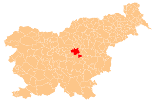
The Municipality of Zagorje ob Savi is a municipality in central Slovenia. The seat of the municipality is the town of Zagorje ob Savi. Traditionally the area was part of the Upper Carniola region. The entire municipality is now included in the Central Sava Statistical Region. The population of the municipality is about 17,000.
Strahovlje is a small settlement in the Municipality of Zagorje ob Savi in central Slovenia. The settlement is part of the traditional region of the Upper Carniola and is included in the Central Sava Statistical Region.
Spodnji Šemnik is a small settlement in the Municipality of Zagorje ob Savi in central Slovenia. The settlement is part of the traditional region of the Upper Carniola and is included in the Central Sava Statistical Region.

Kal is a settlement in the hills west of Zagorje ob Savi in central Slovenia. The area is part of the traditional region of Styria. It is now included with the rest of the Municipality of Zagorje ob Savi in the Central Sava Statistical Region.
Špital is a settlement in the hills west of Zagorje ob Savi in central Slovenia. The area is part of the traditional region of Styria. It is now included with the rest of the Municipality of Zagorje ob Savi in the Central Sava Statistical Region.