Dry's Bluff

Last updated
Dry's Bluff
Drys Bluff from the main road.JPG
Dry's Bluff
Highest point
Elevation 1,340 m (4,400 ft) [1]
Prominence 190 m (620 ft) [1]
Coordinates 41°43′00″S146°48′00″E / 41.71667°S 146.80000°E / -41.71667; 146.80000 [1]
Geography
Relief Map of Tasmania.png
Red triangle with thick white border.svg
Dry's Bluff
Location in Tasmania, Australia
Location Tasmania, Australia
Parent range Great Western Tiers
Topo map

Dry's Bluff is a mountain in the Great Western Tiers Range in Tasmania. The walk to its summit is listed in The Abels as one of the hardest day walks in Tasmania with an elevation gain of over 1000m from the base of the plateau. [2] Access to the start of the walk is through Bob Brown's residence Oura Oura which has the sign Trespassers Welcome on the gate. [3] [4]

Great Western Tiers mountain range

The Great Western Tiers are a collection of mountain bluffs that form the northern edge of the Central Highlands plateau in Tasmania, Australia. The bluffs are contained within the Tasmanian Wilderness World Heritage Site.

Tasmania island state of Australia

Tasmania is an island state of Australia. It is located 240 km (150 mi) to the south of the Australian mainland, separated by Bass Strait. The state encompasses the main island of Tasmania, the 26th-largest island in the world, and the surrounding 334 islands. The state has a population of around 526,700 as of March 2018. Just over forty percent of the population resides in the Greater Hobart precinct, which forms the metropolitan area of the state capital and largest city, Hobart.

The Abels are a group of 158 Tasmanian mountains above 1100m and with a prominence of at least 150m. They are listed in the books The Abels and climbing them all is part of the Tasmanian peakbagging movement.

Contents

Geography and geology

Dry's Bluff lies just south of Liffey at the edge of the central plateau and its summit is 1,340 metres (4,400 ft) above sea level. It is made of Jurassic dolerite columns which are characteristic of the Great Western Tiers.[ citation needed ]

Liffey, Tasmania Town in Tasmania, Australia

Liffey is a town 41 kilometres (25 mi) south-west of Launceston, Tasmania, Australia. It was named by Captain William Moriarty, from Ireland. The town is situated in rainforest, on the Liffey River at the foot of the Great Western Tiers. Nearby towns are Bracknell and Blackwood Creek.

The Jurassic was a geologic period and system that spanned 56 million years from the end of the Triassic Period 201.3 million years ago (Mya) to the beginning of the Cretaceous Period 145 Mya. The Jurassic constitutes the middle period of the Mesozoic Era, also known as the Age of Reptiles. The start of the period was marked by the major Triassic–Jurassic extinction event. Two other extinction events occurred during the period: the Pliensbachian-Toarcian extinction in the Early Jurassic, and the Tithonian event at the end; however, neither event ranks among the "Big Five" mass extinctions.

Access

The walk up Dry's Bluff starts at Oura Oura reserve, owned by Bush Heritage Australia. [5] It then ascends over 1000m in 2.5 km through dry forests, past scree slopes, through the cliff line and into alpine scrub.

Bush Heritage Australia is a non-profit organisation based in Melbourne, Australia, that operates throughout Australia. It was previously known as the Australian Bush Heritage Fund, which is still its legal name. It purchases land, assessed as being of outstanding conservation value, from private owners, to manage as wildlife reserves in perpetuity. It also partners with existing land owners, including Aboriginal groups, to help plan and manage conservation work of important landscapes. It does so to protect endangered species and preserve Australia's biodiversity. By 2018 the organisation was contributing to the protection of 8.86 million hectares on its reserves and partnership lands. There were 5,932 Australian species recorded on their reserves and partnership properties, including 239 threatened species.

Oura Oura with Dry's Bluff in the background House at Drys Bluff.JPG
Oura Oura with Dry's Bluff in the background

Related Research Articles

Protected areas of Tasmania consists of protected areas located within Tasmania and its immediate onshore waters, including Macquarie Island. It includes areas of crown land managed by Tasmanian Government agencies as well as private reserves. As of 2016, 51% of Tasmania's land area has some form of reservation classification, the majority is managed by the Tasmania Parks & Wildlife Service. Marine protected areas cover about 7.9% of state waters.

Mount Wellington (Tasmania) mountain at Hobart, Tasmania

Mount Wellington, officially kunanyi / Mount Wellington, incorporating its Palawa kani name, is a mountain in the southeast coastal region of Tasmania, Australia. It is the summit of the Wellington Range and is within the Wellington Park reserve. Located at the foothills of the mountain is much of Tasmania's capital city, Hobart.

Cradle Mountain mountain

Cradle Mountain is a mountain in the Central Highlands region of the Australian state of Tasmania. The mountain is situated in the Cradle Mountain-Lake St Clair National Park.

Overland Track

The Overland Track is one of Australia's most famous bushwalking (hiking) tracks, situated in the Cradle Mountain-Lake St Clair National Park, Tasmania. More than nine thousand walkers each year complete the track. Officially, the track runs for 65 kilometres (40 mi) from Cradle Mountain to Lake St Clair. However, many choose to add the hike along Lake St Clair as a natural extension, bringing the length to 82 kilometres (51 mi). The track winds through terrain ranging from sheer mountains, temperate rainforest, wild rivers and alpine plains all in the Tasmanian Wilderness World Heritage Area.

Frenchmans Cap mountain in Western Tasmania, located in Wilderness World Heritage area

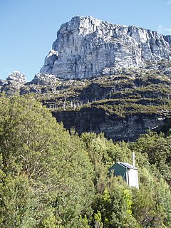
The Frenchmans Cap is a mountain in the West Coast region of Tasmania, Australia. The mountain is situated in the Franklin-Gordon Wild Rivers National Park.

Ben Lomond (Tasmania) plateau in the north of Tasmania

Ben Lomond is a mountain in the north-east of Tasmania, Australia.

Liffey Falls

The Liffey Falls, a series of four distinct tiered–cascade waterfalls on the Liffey River, is located in the Midlands region of Tasmania, Australia.

Eldon Range mountain range

The Eldon Range is a mountain range located in the west coast region of Tasmania, Australia.

Barn Bluff Mountain in Tasmania, Australia

The Barn Bluff is a mountain located in the Central Highlands region of Tasmania, Australia. The mountain is situated in the Cradle Mountain-Lake St Clair National Park at the junction of the eastern most points of the Murchison and Mackintosh river catchments.

Legges Tor mountain

The Legges Tor is the summit of the Ben Lomond mountain range in northeast Tasmania, Australia.

Quamby Bluff mountain in Tasmania, Australia

Quamby Bluff is a mountain in Northern Tasmania, Australia that is an outlying part of the Great Western Tiers mountain range.

Stacks Bluff mountain in Australia

The Stacks Bluff is a peak in northeast Tasmania, Australia. The mountain is situated on the Ben Lomond plateau.

Mount Anne mountain

Mount Anne is a mountain located in the Southwest National Park in south-west region of Tasmania, Australia. The mountain lies within the UNESCO World Heritage-listed Tasmanian Wilderness.

Liffey Valley Reserve Protected area in Tasmania, Australia

The Liffey Valley Reserve is a nature reserve comprising four separate parcels of land, with a combined area of 275 ha, in the Liffey Valley of northern Tasmania, Australia. It lies about 55 km (34 mi) south-west of Launceston and 25 km (16 mi) south-east of Deloraine. It is owned and managed by Bush Heritage Australia (BHA).

Liffey River (Tasmania) river in Tasmania, Australia

The Liffey River is a river in Northern Tasmania, Australia.

Giblin Peak mountain in Tasmania, Australia

The Giblin Peak is a mountain of the Ben Lomond mountain range in northeast Tasmania, Australia. It is the highest elevation on Giblin Fells, a prominent bluff south of Ben Lomond's highest elevation - Legges Tor.

2016 Tasmanian bushfires

The 2016 Tasmanian Bushfires were a large series of bushfires in Tasmania which started in January 2016 throughout the state, and continued into February 2016, with considerable damage to fire sensitive areas in the Central Highlands, West Coast and South West regions. By autumn 2016, no bushfires were reported within the state.

References

  1. 1 2 3 "Drys Bluff, Australia". Peakbagger.com. Retrieved 26 February 2018.
  2. Wilkinson, Bill. The Abels: A comprehensive guide to Tasmania’s mountains over 1100m high. ISBN   9780995367357.
  3. Michael Gordon. "Brown ponders the meaning of Liffey, where the Greens began". Sydney Morning Herald. Retrieved February 26, 2018.
  4. Jessica Kidd. "Trespassers Welcome sign on Bob Brown's former property at Liffey, Tasmania". ABC. Retrieved February 26, 2018.
  5. "Gift of Oura Oura". Bush Heritage Australia. Retrieved February 26, 2018.