
The Malheur River is a 190-mile-long (306 km) tributary of the Snake River in eastern Oregon in the United States. It drains a high desert area, between the Harney Basin and the Blue Mountains and the Snake.

The Harney Basin is an endorheic basin in southeastern Oregon in the United States at the northwestern corner of the Great Basin. One of the least populated areas of the contiguous United States, it is located largely in northern Harney County, bounded on the north and east by the Columbia Plateau—within which it is contained, physiographically speaking—and on the south and west by a volcanic plain. The basin encompasses an area of 1,490 square miles (3,859 km2) in the watershed of Malheur Lake and Harney Lake. Malheur Lake is a freshwater lake, while Harney Lake is saline-alkaline.

Malheur National Wildlife Refuge is a National Wildlife Refuge located roughly 30 miles (48 km) south of the city of Burns in Oregon's Harney Basin. Administered by the United States Fish and Wildlife Service, the refuge area is roughly T-shaped with the southernmost base at Frenchglen, the northeast section at Malheur Lake and the northwest section at Harney Lake.
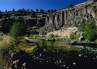
The Donner und Blitzen River is a river on the eastern Oregon high desert which drains a relatively arid basin, the southern portion of Harney Basin, from roughly 20 to 80 miles south-southeast of Burns including Malheur National Wildlife Refuge. Though much of its course is marsh, it offers scenic glaciated canyons, unique ecosystems, and exceptional wild trout fisheries. Named by soldiers of German origin, the Donner und Blitzen River translates as "thunder and lightning". The name usually brings to mind two of Santa Claus' reindeer, but the river is named for a thunderstorm the soldiers experienced as they crossed the river; dry lightning is an almost daily occurrence in the region during certain times of the year.

Malheur Lake is one of the lakes in the Malheur National Wildlife Refuge in Harney County in the U.S. state of Oregon. Located about 18 miles (29 km) southeast of Burns, the lake is a marsh fed by the Donner und Blitzen River from the south and the Silvies River from the north. Malheur Lake periodically overflows into Mud Lake to the west and thence to Harney Lake, the sink of Harney Basin.

Crane is a census-designated place and unincorporated community in Harney County, Oregon, United States, northeast of Malheur Lake on Oregon Route 78. Its population was 129 at the 2010 census.

Harney Lake is a shallow alkali lake basin located in southeast Oregon, United States, approximately 30 miles (48 km) south of the city of Burns. The lake lies within the boundary of the Malheur National Wildlife Refuge and is the lowest point in the Blitzen Valley drainage.
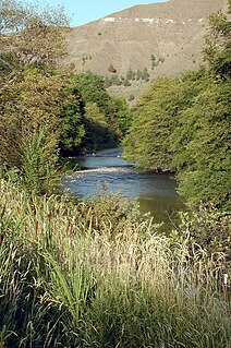
The South Fork John Day River is a 60-mile (97 km) tributary of the John Day River in the U.S. state of Oregon. It begins in the Malheur National Forest in Harney County about 25 miles (40 km) north-northwest of Burns and flows generally north to Dayville, where it meets the main stem of the John Day River. Along the way, the stream passes through the abandoned town of Izee. Black Canyon Wilderness in the Ochoco National Forest lies within the river's drainage basin.
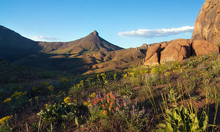
The Trout Creek Mountains are a remote, semi-arid Great Basin mountain range mostly in southeastern Oregon and partially in northern Nevada in the United States. The range's highest point is Orevada View Benchmark, 8,506 feet (2,593 m) above sea level, in Nevada. Disaster Peak, elevation 7,781 feet (2,372 m), is another prominent summit in the Nevada portion of the mountains.

The Sod House Ranch is an historic ranch in Harney County in southeastern Oregon, United States. The remaining ranch structures are located south of Malheur Lake in the Malheur National Wildlife Refuge. The ranch was built by Peter French, a well known 19th-century cattle baron. The Sod House Ranch became the headquarters for the northern operating division of the French-Glenn Livestock Company, which eventually covered over 140,000 acres (570 km2). After French was murdered in 1897, the French-Glenn Livestock Company slowly sold off its ranch property. In 1935, the United States Government purchased the Sod House Ranch property to add to an adjacent wildlife refuge. The eight remaining Sod House Ranch buildings are now listed on the National Register of Historic Places.

Silver Creek is an 87-mile (140 km) stream of Oregon which drains a portion of the endorheic Harney Basin to Harney Lake. Arising in the Blue Mountains, it flows generally southeast, although much of the stream is intermittent. The Silver Creek Volcanic Field is associated with the creek's watershed.

The North Fork Malheur River is a 59-mile (95 km) tributary of the Malheur River in eastern Oregon in the United States. Rising in Big Cow Burn in the Blue Mountains, it flows generally south to join the larger river at Juntura. The upper 25.5 miles (41.0 km) of the river have been designated Wild and Scenic. This part of the river basin offers camping, hiking, and fishing opportunities in a remote forest setting. The lower river passes through Beulah Reservoir, which stores water for irrigation and has facilities for boaters.

Dry Creek is a tributary, 54 miles (87 km) long, of Crooked Creek in the U.S. state of Oregon. The creek, which is intermittent, begins in the desert near Five Points in Malheur County. It joins Crooked Creek east of Burns Junction and about 7 miles (11 km) south of the larger stream's confluence with the Owyhee River. Dry Creek drains a basin of about 299 square miles (770 km2).

Willow Creek is a 57-mile (92 km) tributary of the Malheur River in Malheur County in the U.S. state of Oregon. The creek, which forms at 3,724 feet (1,135 m) above sea level and ends at 2,234 feet (681 m), flows generally southeast between Ironside and Vale. Willow Creek's watershed covers 787 square miles (2,040 km2) of relatively arid land.

The Double-O Ranch Historic District is located west of Harney Lake in Harney County in southeastern Oregon, United States. At one time, the Double-O Ranch covered over 17,000 acres (69 km2). The ranch was owned by Bill Hanley, a well-known cattle baron and Bull Moose progressive. In 1941, the United States Government purchased most of the Double O Ranch property and added it to the Malheur National Wildlife Refuge. The two remaining Double-O Ranch buildings are now listed on the National Register of Historic Places.
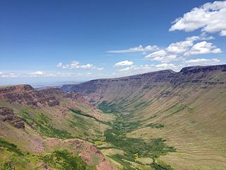
Kiger Creek is a tributary of Swamp Creek in Harney County in the U.S. state of Oregon. It originates on Steens Mountain and flows generally north through Kiger Gorge to meet Swamp Creek near the unincorporated community of Diamond. The combined streams flow into Diamond Swamp and the Malheur National Wildlife Refuge.
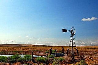
Voltage is an unincorporated community in Harney County, Oregon, United States. It is about 34 miles (55 km) south of Burns, on the south shore of Malheur Lake near the Donner und Blitzen River.

The Whitehorse Ranch is a historic cattle ranch in Harney and Malheur counties in the southeastern corner of Oregon, United States. The ranch was started in 1869 by John S. Devine, a well-known 19th-century cattle baron. It was originally the headquarters for the Todhunter and Devine Cattle Company. The ranch has been in the cattle business continuously since it was founded. Today, the Whitehorse Ranch includes 63,222 acres (255.85 km2) of deeded property and grazing rights on an additional 287,205 acres (1,162.28 km2) of public range land administered by the Bureau of Land Management.


