Dublin 8

Last updated
Dublin 8 (D8)
Baile Átha Cliath 8
Postal district
Dublin D08.jpg
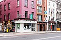
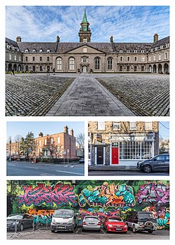
Clockwise from top: Royal Hospital Kilmainham, a shopfront in Portobello, graffiti near Meath Street, the South Circular Road
Country Ireland
Province Leinster
Local Authority Dublin City Council
Dáil constituency Dublin South-Central, Dublin West
EP constituency Dublin
Postal district(s)
D8/D08
Dialing code01, +353 1

Dublin 8, also rendered as D8 and D08, is a historic postal district in Dublin. D8 is one of only two postal districts to span the River Liffey. While the majority of the code's built up areas are on the southside, it also includes northside areas such as the vast Phoenix Park. [1] A 2018 article in The Irish Times noted that, while the area was historically known for the manufacture of silk and wool, Dublin 8's "streets, alleys and quaysides are [now] replete with hipster cafes, cocktail bars and family-friendly restaurants". [2]

Contents

Area profile

Dublin 8 was named one of the "coolest neighbourhoods" in the world by Time Out in 2021. [3] Forecasting by Knight Frank, which put the area on a so-called global hot list, has indicated the district could face property price growth of up to 20% in the coming years. [4] However, further research has shown that rapid, large-scale transformation and gentrification in the postal code has left some of its residents feeling powerless and voiceless. [5]

On Heytesbury Street, the area is home to the largest collection of intact one floor over basement houses in the city. This is a style of home unique to Ireland. The Victorian structures were built for the lower middle classes from the 1830s onwards, as the city's population increased despite the Great Famine. [6]

Notable places

Dublin 8 includes Dolphin's Barn, Inchicore, Islandbridge, Kilmainham, Merchants Quay, Portobello, South Circular Road, the Phoenix Park and the Liberties. Notable buildings include Christ Church Cathedral and St. Patrick's Cathedral.

Usage in Dublin addresses

Colloquially, Dubliners simply refer to the area as "Dublin 8". The postal district forms the first part of numerous seven digit Eircodes that are unique to every single address in the area. For addressing purposes, it appears in both its original form as Dublin 8 and as the first part of a seven digit postal code as D08 a line below. [7] For example:

Liberties College   Bull Alley Street Dublin 8 D08 A8N0

See also

Related Research Articles

<span class="mw-page-title-main">Postal code</span> Series of letters and digits for sorting mail

A postal code is a series of letters or digits or both, sometimes including spaces or punctuation, included in a postal address for the purpose of sorting mail.

<span class="mw-page-title-main">Postcodes in the United Kingdom</span>

Postal codes used in the United Kingdom, British Overseas Territories and Crown dependencies are known as postcodes. They are alphanumeric and were adopted nationally between 11 October 1959 and 1974, having been devised by the General Post Office. A full postcode is known as a "postcode unit" and designates an area with several addresses or a single major delivery point.

<span class="mw-page-title-main">Dublin 4</span> Postal district in Leinster, Ireland

Dublin 4, also rendered as D4 and D04, is a historic postal district of Dublin, Ireland including Baggot Street Upper, the southernmost fringes of the Dublin Docklands, and the suburbs of Ballsbridge, Donnybrook, Irishtown, Merrion, Ringsend and Sandymount, on the Southside of Dublin. Most of the area was known as Pembroke Township until 1930 when it was absorbed by the City and County Borough of Dublin.

<span class="mw-page-title-main">Northside, Dublin</span> Informal division of Dublin, Ireland

The Northside is the part of Dublin city that lies to the north of the River Liffey. It is an informal but commonly used term. While it is sometimes regarded as less wealthy than the city's Southside, the Northside was originally the home of the city's upper classes and the more privileged of the two. Today, some of the wealthiest areas in Ireland lie north of the river, such as Malahide, Howth, Clontarf, and Castleknock.

<span class="mw-page-title-main">Southside, Dublin</span> Informal region in Dublin, Ireland

The Southside is the part of Dublin city that lies south of the River Liffey. It is an informal but commonly used term. In comparison to the city's Northside, it has historically been regarded as wealthier and more privileged, with several notable exceptions.

A geocode is a code that represents a geographic entity. It is a unique identifier of the entity, to distinguish it from others in a finite set of geographic entities. In general the geocode is a human-readable and short identifier.

An address is a collection of information, presented in a mostly fixed format, used to give the location of a building, apartment, or other structure or a plot of land, generally using political boundaries and street names as references, along with other identifiers such as house or apartment numbers and organization name. Some addresses also contain special codes, such as a postal code, to make identification easier and aid in the routing of mail.

<span class="mw-page-title-main">Portobello, Dublin</span> Inner city area of Dublin, Ireland

Portobello is an area of Dublin in Ireland, within the southern city centre and bounded to the south by the Grand Canal. It came into existence as a small suburb south of the city in the 18th century, centred on Richmond Street. During the following century it was completely developed, transforming an area of private estates and farmland into solid Victorian red-bricked living quarters for the middle classes on the larger streets, and terraced housing bordering the canal for the working classes.

D8, D.VIII, D VIII, D08 or D-8 may refer to:

<span class="mw-page-title-main">Dublin 2</span> Postal district in Leinster, Ireland

Dublin 2, also rendered as D2 and D02, is a historic postal district on the southside of Dublin, Ireland. In the 1960s, this central district became a focus for office development. More recently, it became a focus for urban residential development. The district saw some of the heaviest fighting during Ireland's Easter Rising.

<span class="mw-page-title-main">Postal addresses in the Republic of Ireland</span> Postal code system of Ireland

A postal address in Ireland is a place of delivery defined by Irish Standard (IS) EN 14142-1:2011 and serviced by the universal service provider, An Post. Its addressing guides comply with the guidelines of the Universal Postal Union (UPU), the United Nations-affiliated body responsible for promoting standards in the postal industry, across the world.

<span class="mw-page-title-main">Stoneybatter</span> Neighbourhood in northern inner-city Dublin, Ireland

Stoneybatter, historically known as Bohernaglogh, is a neighbourhood of Dublin, Ireland, on the Northside of the city between the River Liffey, the North Circular Road, Smithfield Market, and Grangegorman. It is in the D7 postal district. The name dates from at least 1603.

<span class="mw-page-title-main">Dublin 15</span> Postal district of Dublin, Ireland

Dublin 15, also rendered as D15, is a postal district in the suburbs of Dublin in Fingal, Ireland. It is 11 km (6.8 mi) west of the GPO in Dublin city.

<span class="mw-page-title-main">Dublin 1</span> Postal district in Leinster, Ireland

Dublin 1, also rendered as D1 and D01, is a historic postal district on the northside of Dublin, Ireland.

<span class="mw-page-title-main">The Liberties, Dublin</span> Historic area of central Dublin, Ireland

The Liberties is an area in central Dublin, Ireland, located in the southwest of the inner city. Formed from various areas of special manorial jurisdiction, separate from the main city government, it is one of Dublin's most historic working class neighbourhoods. The area was traditionally associated with the River Poddle, market traders and local family-owned businesses, as well as the Guinness brewery, whiskey distilling, and, historically, the textiles industry and tenement housing.

Postal codes in Singapore have consisted of six digits since 1995, replacing the four-digit system introduced in 1979. They are administered by Singapore Post.

Postal codes were adopted in Ghana on 18 October 2017, following the launch of the National Digital Address System. As a joint venture between Ghana Post and Vokacom Ltd as GhanaPost GPS, the Digital Address System assigned postal codes and unique addresses to every square in Ghana.

References

  1. "An Irishman's Diary on Dublin's vanishing postal districts". The Irish Times. Retrieved 2022-07-16.
  2. "Make a culture date with Dublin 8". The Irish Times. Retrieved 2022-07-16.
  3. Dickinson, Sophie. "Dublin 8 has been named one of the world's coolest neighbourhoods – here's why". Time Out Worldwide. Retrieved 2022-07-16.
  4. "Dublin 8 is 'primed for prosperity', alongside four other global neighbourhoods". The Irish Times. Retrieved 2022-07-16.
  5. "Mapping Green Dublin: Strategic Pathways to Community-led Greening". scholar.googleusercontent.com. Retrieved 2022-07-16.
  6. Conway, Richard (31 May 2022). "The Design History of Dublin's Over-basement Row Houses". Bloomberg News.
  7. "Eircode Postcodes: What you need to know about Ireland's new postcode system". The Irish Independent. Retrieved 2022-07-15.