
Lae is the capital of Morobe Province and is the second-largest city in Papua New Guinea. It is located near the delta of the Markham River and at the start of the Highlands Highway, which is the main land transport corridor between the Highlands region and the coast. Lae is the largest cargo port of the country and is the industrial hub of Papua New Guinea. The city is known as the Garden City and home of the University of Technology.

For administrative purposes, Papua New Guinea is divided into administrative divisions called provinces. There are 22 province-level divisions, which include 20 provinces, the autonomous region of Bougainville and the National Capital District of Port Moresby.

The Dani people, also spelled Ndani, and sometimes conflated with the Lani group to the west, are a people from the central highlands of western New Guinea.
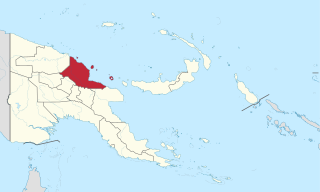
Madang is a province of Papua New Guinea. The province is on the northern coast of mainland Papua New Guinea and has many of the country's highest peaks, active volcanoes and its biggest mix of languages. The capital is the town of Madang.

Southern Highlands is a province in Papua New Guinea. Its provincial capital is the town of Mendi. According to Papua New Guinea's national 2011 census, the total population of Southern Highlands is 515,511 spread across 15,089 square kilometers (5,826 sq mi).

The Anglican Church of Papua New Guinea is a province of the Anglican Communion. It was created in 1976 when the Province of Papua New Guinea became independent from the Province of Queensland in the Church of England in Australia following Papua New Guinea's independence in 1975.

The South Halmahera–West New Guinea (SHWNG) languages are a branch of the Malayo-Polynesian languages, found in the islands and along the shores of the Halmahera Sea in the Indonesian province of North Maluku and of Cenderawasih Bay in the provinces of Papua and West Papua. There are 38 languages.
Dadibi is a language of Papua New Guinea. In 2001, the whole Bible was translated into Dadibi.
Vida Chenoweth was the first professional solo classical marimbist, an ethnomusicologist and a linguist.
Huli is a Tari language spoken by the Huli people of the Hela Province of Papua New Guinea. It has a pentadecimal (base-15) numeral system: ngui means 15, ngui ki means 15×2 = 30, and ngui ngui means 15×15 = 225.
Kaugel (Gawigl) is one of the languages spoken in the Southern Highlands province of Papua New Guinea. Native speakers call the area on the Southern Highlands side of the Kaugel River from the Western Highlands province home.
The Ambai language is an Austronesian language spoken in Indonesian New Guinea, mostly on the Ambai Islands as well as the southern part of Yapen Island. The number of speakers is estimated to be 10,000. Dialects are Randawaya, Ambai (Wadapi-Laut), and Manawi.
Simberi Island is a volcanic island in the Tabar Group, in Papua New Guinea's New Ireland Province.

New Guinea is the world's second-largest island and, with an area of 785,753 km2 (303,381 sq mi), the largest island wholly or partly within the Southern Hemisphere and Oceania. Located in Melanesia in the southwestern Pacific Ocean, it is separated by the 150-kilometre wide Torres Strait from the Australian continent. Numerous smaller islands are located to the west and east. The eastern half of the island is the major land mass of the independent state of Papua New Guinea. The western half, known as Western New Guinea or West Papua, forms a part of Indonesia and is organized as the provinces of Papua and West Papua.
The Hewa are an indigenous people that live in the Koroba Lake Kopiago Electorate of Hela Province of Papua New Guinea near the junction of the Strickland River.They were one of the last peoples in Papua New Guinea to come into contact with the outside world. They number about 2,000 persons, and their rugged rainforest terrain comprises about 200 square miles (518 km2), some of which was unexplored until 2008. Their language belongs to the Sepik family.
Awtuw (Autu), also known as Kamnum, is spoken in Sandaun Province, Papua New Guinea. It is a polysynthetic language closely related to Karawa and Pouye. It is spoken in Galkutua, Gutaiya, Kamnom, Tubum, and Wiup villages in Kamnom East ward, East Wapei Rural LLG, Sandaun Province.

Duna is a Papuan language of Papua New Guinea. It may belong to the Trans New Guinea language family and is often further classified as a Duna-Pogaya language, for Bogaya appears to be Duna's closest relative, as evidenced by the similar development of the personal pronouns. Estimates for number of speakers range from 11,000 (1991) to 25,000 (2002).
Mari is an endangered Sepik language spoken in East Sepik Province, Papua New Guinea.

Hela is a province of Papua New Guinea. The provincial capital is Tari. The province covers an area of 10,498 km², and there are 249,449 inhabitants. Hela province officially came into being on 17 May 2012, comprising three districts previously part of Southern Highlands Province.

The karuka is a species of tree in the family Pandanaceae and an important regional food crop in New Guinea. The nuts are more nutritious than coconuts, and are so popular that villagers in the highlands will move their entire households closer to trees for the harvest season.

