Location
Dunbeg Fort is located on a rocky promontory just south of Slea Head on the Dingle Peninsula, looking over Dingle Bay to the south and the Atlantic Ocean to the west. The cliffs have eroded since it was built, and much of the fort has been lost to the sea. The fort's wall cut off access to the triangular promontory, which was later occupied by a single large "beehive" hut. Near to the fort there is a group of clocháns , small stone structures also known as beehive huts that seem to have been built around 1000 BC.
A visitor center at the site includes audiovisual displays, an information and craft room and a restaurant and café.
In January 2014 the fort was closed when much of the western wall of the fort fell into the sea due to storm damage. [5] The Office of Public Works and National Monuments Service sent personnel to investigate damage to the site. [5]
The fort was again closed in December 2017 and separately in January 2018 after further damage was inflicted by the season's storms.
Because of its exposed location, the location of Dunbeg Fort makes it vulnerable to natural weather events and the site's existence is threatened. The Office of Public Works has taken mitigating measures to reduce the impact of climate change on this site and protect its architectural, archaeological and natural features. [6]
Structure
George Victor Du Noyer described the fort as it was when he visited in 1858. The fort divided the point of a headland from the main shore with a dry stone wall between 15 and 25 feet (4.6 and 7.6 m) in width and about 200 feet (61 m) long from one side of the headland to the other. A passage near the midpoint leads through the wall, which was then 3.5 feet (1.1 m) high, [lower-alpha 1] 2 feet (0.61 m) wide at the top and 3 feet (0.91 m) wide at the base. The lintel is 7 feet (2.1 m) long. The passage widens to 8 feet (2.4 m) inside the fort, with an arched ceiling.
In front of the defensive wall there are four parallel ditches separated by three clay and gravel mounds. A pathway leads through this defence to the entrance of the fort. It seems that originally the path ran through a stone passage with a flagged roof as it passed through each mound. Possibly the earth ramparts were built first, then the rock wall added later to strengthen the defences. The wall itself was at first 8 to 11 feet (2.4 to 3.4 m) thick, with the landward face later built out to as much as 22 feet (6.7 m) near the entrance.
To the right of the entrance passage there is a rectangular room built into the wall. It is about 10 by 6 feet (3.0 by 1.8 m) that can be entered from the passage by a low square opening. A broad bench-like seat is opposite this opening in the passage. To the left of the passage is another, similar room, accessible from the fort through a low square opening, but not accessible from the passage. The wall contains long, narrow passages on either side of the entrance, which would have been covered over. They seem to have been inaccessible, so their purpose is not known. The interior of the wall slopes, forming steps, presumably to give access to a parapet.
Inside the fort Du Noyer found traces of several clocháns , or drystone huts whose layout was no longer clear. There were traces of a wall along the cliff to the west, which is about 90 feet (27 m) above sea level. Two parallel walls ran from the fort up to the slopes of Mount Eagle, separating the lands round the Fahan settlement from the land to the east.
Due to erosion in December 2017 and early 2018 substantial damage has been done to the entrance doorway which has been declared unsafe by the OPW and is closed to visitors. [10]

In archaeology, a broch is an Iron Age drystone hollow-walled structure found in Scotland. Brochs belong to the classification "complex Atlantic roundhouse" devised by Scottish archaeologists in the 1980s.

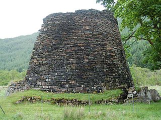
A clochán or beehive hut is a dry-stone hut with a corbelled roof, commonly associated with the south-western Irish seaboard. The precise construction date of most of these structures is unknown with the buildings belonging to a long-established Celtic tradition, though there is at present no direct evidence to date the surviving examples before c. 700 CE. Some associated with religious sites may be pre-Romanesque, some consider that the most fully intact structures date after the 12th century or later. It is where monks lived.

A promontory fort is a defensive structure located above a steep cliff, often only connected to the mainland by a small neck of land, thus using the topography to reduce the ramparts needed.
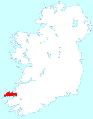
The Dingle Peninsula is the northernmost of the major peninsulas in County Kerry. It ends beyond the town of Dingle at Dunmore Head, the westernmost point of Ireland.

Ventry, officially Ceann Trá, is a Gaeltacht village in County Kerry, Ireland, on the Dingle Peninsula, 7 kilometres west of Dingle. Due to its long sandy beach, Ventry is a tourist destination.

Caherconree at 835 metres (2,740 ft), is the 20th–highest peak in Ireland on the Arderin scale, and the 27th–highest peak on the Vandeleur-Lynam scale. Caherconree is the 2nd-highest mountain in the Slieve Mish Mountains in the Dingle Peninsula in County Kerry, Ireland, and one of its southerly spurs is the site of an ancient stone promontory fort, which is a protected National Monument.

Dún Dúchathair or simply Dúchathair, meaning "black fort", is a large stone fort on the cliffs at Cill Éinne, (Killeany), Inishmore in County Galway, Ireland. Due to erosion, it now sits on a rocky promontory that stretches out into the sea. On its outer side there are large walls, reaching 6 metres high and 5 metres wide. On the inside are the ruins of clocháns. There is also evidence of a cheval de frise protecting the entrance.

Doonshean or Doonsheane is a townland in western County Kerry in Ireland. It is located about 3.8 km east from the neighbouring town of Dingle.

Cornish promontory forts, commonly known in Cornwall as cliff castles, are coastal equivalents of the hill forts and Cornish "rounds" found on Cornish hilltops and slopes. Similar coastal forts are found on the north–west European seaboard, in Normandy, Brittany and around the coastlines of the British Isles, especially in Wales, Scotland and Ireland. Many are known in southwest England, particularly in Cornwall and its neighbouring county, Devon. Two have been identified immediately west of Cornwall, in the Isles of Scilly.

Huxter Fort is an Iron Age fortification on the island of Whalsay, in the Shetland islands of Scotland, dating to around 300 BC. It is on an islet in the Loch of Huxter, connected to the shore by a causeway.
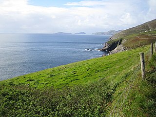
Fahan is an area on the Dingle Peninsula in County Kerry, Ireland, noted for a collection of clochán, or drystone beehive huts. Fahan lies below Mount Eagle on the southern coast of the Dingle peninsula, to the west of the fishing village of Ventry and to the east of the steep cliffs of Slea Head. Fahan has many antiquities, including cave dwellings, stone beehive huts, stone monuments and forts.
Dun Telve is an iron-age broch located about four kilometres (2.5 mi) southeast of the village of Glenelg, Inverness-shire in the Highland Region of Scotland. It is one of the best preserved brochs in Scotland.

Dun Troddan is an iron-age broch located about 5 kilometres (3.1 mi) southeast of the village of Glenelg, Highland, in Scotland. It is one of the best-preserved brochs in Scotland.

Dun Beag is an iron-age broch located about 1 kilometre northwest of the village of Struan on the west coast of the island of Skye, in Scotland.

Dun Ardtreck is a D-shaped dun, or "semi-broch", located on the west coast of the island of Skye, in Scotland.
Leacanabuaile is a stone ringfort (cashel) and National Monument in County Kerry, Ireland. Leacanabuaile is immediately northwest of Cahergal, 3 km (1.9 mi) northwest of Cahirciveen.

Glanfahan is a townland on the Dingle Peninsula, Ireland, notable for its large collection of clocháns, which form a National Monument.
Doonmore is a promontory fort and National Monument located in County Kerry, Ireland.

Commas is a townland in the civil parish of Kinawley, barony of Tullyhaw, County Cavan, Ireland. Sub-divisions of the townland are- (a) The Strait - A name given to a hollow in the townland up near Cuilcagh mountain; (b) Knocknamaddoo (Irish derived place name Cnoc na Mada, meaning ‘The Hill of the Dogs ’; Sruhan Doo, Easa Iarainn and Loinin, are names given to streams flowing down the mountain in Commas.

Kemp Law Dun is a vitrified fort dating from the Iron Age situated near the town of Dundonald in South Ayrshire, Scotland. The remains of the Iron Age fort or dun lie on the old Auchans Estate in the Dundonald Woods near the site of the old Hallyards Farm and the quarry of that name. The footpath route known as the Smugglers' Trail through the Clavin Hills from Troon to Dundonald runs passed the ruins of the dun. Kemps Law is in the order of two thousand years old.


