
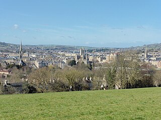
Somerset, archaically Somersetshire is a ceremonial county in South West England. It is bordered by the Bristol Channel, Gloucestershire, and Bristol to the north, Wiltshire to the east, Dorset to the south-east, and Devon to the south-west. The largest settlement is the city of Bath, and the county town is Taunton.

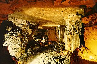
Cheddar Gorge is a limestone gorge in the Mendip Hills, near the village of Cheddar, Somerset, England. The gorge is the site of the Cheddar show caves, where Britain's oldest complete human skeleton, Cheddar Man, estimated to be 9,000 years old, was found in 1903. Older remains from the Upper Late Palaeolithic era have been found. The caves, produced by the activity of an underground river, contain stalactites and stalagmites. The gorge is part of a Site of Special Scientific Interest called Cheddar Complex.
Bath and North East Somerset (B&NES) is a unitary authority district in Somerset, South West England. Bath and North East Somerset Council was created on 1 April 1996 following the abolition of the county of Avon. It is part of the ceremonial county of Somerset.

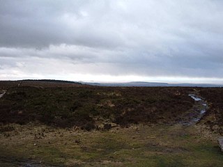
The Mendip Hills is a range of limestone hills to the south of Bristol and Bath in Somerset, England. Running from Weston-super-Mare and the Bristol Channel in the west to the Frome valley in the east, the hills overlook the Somerset Levels to the south and the Chew Valley and other tributaries of the Avon to the north. The highest point, at 325 metres (1,066 ft) above sea level, is Beacon Batch which is the summit area atop Black Down. The hills gave their name to the former local government district of Mendip, which administered most of the local area until April 2023. The higher, western part of the hills, covering 198 km2 (76 sq mi) has been designated an Area of Outstanding Natural Beauty (AONB), which gives it a level of protection comparable to a national park.
Little Solsbury Hill is a small flat-topped hill and the site of an Iron Age hill fort, above the village of Batheaston in Somerset, England. The hill rises to 625 feet (191 m) above the River Avon, which is just over 1 mile (2 km) to the south, and gives views of the city of Bath and the surrounding area. It is within the Cotswolds Area of Outstanding Natural Beauty.
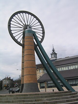
Radstock is a town and civil parish on the northern slope of the Mendip Hills in Somerset, England, about 9 miles (14 km) south-west of Bath and 8 miles (13 km) north-west of Frome. It is within the area of the unitary authority of Bath and North East Somerset. The Radstock built-up area had a population of 9,419 at the 2011 Census.
William Lonsdale, English geologist and palaeontologist, won the Wollaston medal in 1846 for his research on the various kinds of fossil corals.

Brean Down is a promontory off the coast of Somerset, England, standing 318 feet (97 m) high and extending 1+1⁄2 miles into the Bristol Channel at the eastern end of Bridgwater Bay between Weston-super-Mare and Burnham-on-Sea.

Burrington Combe is a Carboniferous Limestone gorge near the village of Burrington, on the north side of the Mendip Hills Area of Outstanding Natural Beauty, in North Somerset, England.

The Polden Hills in Somerset, England are a long, low ridge, extending for 10 miles (16 km), and separated from the Mendip Hills, to which they are nearly parallel, by a marshy tract, known as the Somerset Levels. They are now bisected at their western end by the M5 motorway and a railway, the Bristol and Exeter Railway, part of the Great Western Main Line.
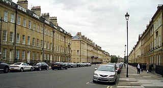
Bath stone is an oolitic limestone comprising granular fragments of calcium carbonate originally obtained from the Middle Jurassic aged Great Oolite Group of the Combe Down and Bathampton Down Mines under Combe Down, Somerset, England. Its honey colouring gives the World Heritage City of Bath, England, its distinctive appearance. An important feature of Bath Stone is that it is a 'freestone', so-called because it can be sawn or 'squared up' in any direction, unlike other rocks such as slate, which form distinct layers.

Somerset is a rural county in the southwest of England, covering 4,171 square kilometres (1,610 sq mi). It is bounded on the north-west by the Bristol Channel, on the north by Bristol and Gloucestershire, on the north-east by Wiltshire, on the south-east by Dorset, and on the south west and west by Devon. It has broad central plains with several ranges of low hills. The landscape divides into four main geological sections from the Silurian through the Devonian and Carboniferous to the Permian which influence the landscape, together with water-related features.
Black Down is the highest hill in the Mendip Hills, Somerset, in south-western England. Black Down lies just a few miles eastward of the Bristol Channel at Weston-super-Mare, and provides a view over the Chew Valley. The summit is marked with an Ordnance Survey trig point, the base of which has been rebuilt by the Mendip Hills AONB authority.
Horace Bolingbroke Woodward, was a British geologist who participated in the Geological Survey of England and Wales from 1867 until his retirement in 1908. He was vice-president of the Geological Society, where he was elected a Fellow in 1868; elected a Fellow of the Royal Society in 1896, awarded the Murchison Medal in 1897, and the Wollaston Medal in 1909.
Browne's Folly, or Brown's Folly, is a folly tower sitting within a 39.9 hectare biological and geological Site of Special Scientific Interest (SSSI) near the English village of Bathford in Somerset, notified in 1974: the site itself is known as the Farleigh Down Stone Quarry and is managed as a nature reserve by the Avon Wildlife Trust (AWT). The tower was built in 1848 and is a Grade II listed building.

Dolebury Warren is a 90.6-hectare (224-acre) biological Site of Special Scientific Interest (SSSI) and ancient monument near the villages of Churchill and Rowberrow in North Somerset, part of South West England. It is owned by the National Trust, who acquired the freehold in 1983, and managed by the Avon Wildlife Trust.

Bathampton Down is a flat limestone plateau in Bathampton, Somerset, England, overlooking the River Avon and the city of Bath. There is evidence of man's activity at the site since the Mesolithic period including Bathampton Camp, an Iron Age hillfort or stock enclosure. It has also been used for quarrying, and part of it is now a golf course.
The Somerset Coalfield in northern Somerset, England is an area where coal was mined from the 15th century until 1973. It is part of a larger coalfield which stretched into southern Gloucestershire. The Somerset coalfield stretched from Cromhall in the north to the Mendip Hills in the south, and from Bath in the east to Nailsea in the west, a total area of about 240 square miles (622 km2). Most of the pits on the coalfield were concentrated in the Cam Brook, Wellow Brook and Nettlebridge Valleys and around Radstock and Farrington Gurney. The pits were grouped geographically, with clusters of pits close together working the same coal seams often under the same ownership. Many pits shared the trackways and tramways which connected them to the Somerset Coal Canal or railways for distribution.

The county of Somerset is in South West England, bordered by the Bristol Channel and the counties of Bristol and Gloucestershire to the north, and Wiltshire to the east, Dorset to the south, and Devon to the west. The climate, influenced by its proximity to the Atlantic Ocean and the prevailing westerly winds, tends to be mild, damp and windy.

