Thiruneermalai is a neighborhood of Tambaram located within the Chennai Metropolitan Area, India. Originally a town panchayat in Chengalpattu district, Thiruneermalai is now a part of Pammal Zone under Tambaram Municipal Corporation.
Chandlodia is an area under Ahmedabad Municipal Corporation in Ahmedabad district in the state of Gujarat, India.
Chinnasekkadu is a neighbourhood of Chennai in Chennai district in the state of Tamil Nadu, India. Chinnasekkadu used to be a town panchayat in Thiruvallur district. In 2011, Chinnasekkadu town panchayat was merged with Chennai Corporation. Chinnasekkadu comes under ward 29 in Zone 3(Madhavaram) of Chennai Corporation.
Hailymandi is a town and a municipal council in Gurgaon district in the Indian state of Haryana. It was the market town of the erstwhile Pataudi State before Indian independence. Nearby is the temple of 'Baba Hardeva'.
Jharia Khas is a neighbourhood in Dhanbad in Dhanbad Sadar subdivision of Dhanbad district in Jharkhand state, India.
Lakarka is a neighbourhood in Dhanbad in Dhanbad Sadar subdivision of Dhanbad district in Jharkhand state, India.
Lambha is a census town in Ahmadabad district in the Indian state of Gujarat. Parts of Vejalpur, Daskroi, Danilimda, Vatva, and Maninagar assembly constituencies jut into Lambha. Many parts of Kheda, Gandhinagar, Ahmedabad West, and Ahmedabad East Lok Sabha constituencies fall in Lambha.
Meerpet–Jillelguda is a satellite city of Hyderabad and a municipal corporation in Rangareddy district of the Indian state of Telangana. The municipal corporation was formed after merging municipality of Meerpet and Jillelguda.
Nadathara is a residential area situated in the City of Thrissur in Kerala state of India. Nadathara is Ward 22 of Thrissur Municipal Corporation. As of 2001 India census, Nadathara had a population of 12,593. Males constitute 49% of the population and females 51%. Nadathara has an average literacy rate of 84%, higher than the national average of 59.5%: male literacy is 86%, and female literacy is 82%.
Nagapur is a census town in Ahmadnagar district in the Indian state of Maharashtra.

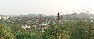
Olavanna is a census town in Kozhikode district in the Indian state of Kerala. Olavanna is the most populous panchayat in kerala. It is located 10 km from Kozhikode City. Olavanna panchayath shares the border with Kozhikode corporation and Perumanna panchayath. At first it was a large agricultural area. Today there are many small and large scale industries. There are also small marketplaces such as the Pantheerankavu, Olavanna Chungam, Kodinattumukku, Mathara, Palazhi, Kunnathupalam, Iringallor. The railway station is around 10 kilometres away and the nearest airport is Calicut international Airport. HiLite Mall is located in Palazhi junction.
Peerkankaranai is a neighborhood of Tambaram and part of the Chennai Metropolitan Area in the Indian state of Tamil Nadu. Originally a town panchayat,it was merged with the Tambaram Municipal Corporation in 2021.
Pooluvapatti is a panchayat town in Coimbatore district in the Indian state of Tamil Nadu. It is a western suburb of Coimbatore and lies close to Kerala border. Pooluvapatti comes under Coimbatore Municipal Corporation.
Rohraband is a neighbourhood in Dhanbad in Dhanbad Sadar subdivision of Dhanbad district in Jharkhand state, India.
Sukhrali is a census town in Gurgaon district in the Indian state of Haryana.
Thaltej is a census town and a suburb in Ahmedabad district in the Indian state of Gujarat. The town comes under Ward No:8, North West Zone of Ahmedabad Municipal Corporation, the civic body that governs the City of Ahmedabad.
Thirunagar is a neighborhood within the Madurai district in the Indian state of Tamil Nadu.

Uppal is a suburb in Eastern Hyderabad, Telangana, India. It is the mandal headquarters of Uppal mandal in Keesara revenue division in Medchal-Malkajgiri district. It forms Circle No.2 in the L. B. Nagar Zone of Greater Hyderabad Municipal Corporation. There are four wards i.e., Chilukanagar (7), Habsiguda (8), Ramanthapur (9) and Uppal (10) in this circle.
Upper Tadong is a census town in Gangtok District in the Indian state of Sikkim. It falls under Gangtok Municipal Corporation.
Vejalpur is a Census Town in the New West Zone of the metropolitan city of Ahmedabad in the Indian state of Gujarat.


