
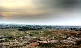
Gurgaon, officially named Gurugram, is a city located in the northern Indian state of Haryana. It is situated near the Delhi–Haryana border, about 30 kilometres (19 mi) southwest of the national capital New Delhi and 268 km (167 mi) south of Chandigarh, the state capital. It is one of the major satellite cities of Delhi and is part of the National Capital Region of India. As of 2011, Gurgaon had a population of 1,153,000.

The National Capital Region (NCR) is a planning region centred upon the National Capital Territory (NCT) of Delhi in India. It encompasses Delhi and several districts surrounding it from the states of Haryana, Uttar Pradesh and Rajasthan. The NCR and the associated National Capital Region Planning Board were created in 1985 to plan the development of the region and to evolve harmonized policies for the control of land-uses and development of infrastructure in the region. Prominent cities of NCR include Delhi, Faridabad, Ghaziabad, Gurugram, and Noida.
Mahendragarh is a city and a municipal committee in Mahendragarh district in the Indian state of Haryana. It is 100 kilometres (62 mi) from Gurgaon and comes under National Capital Region (India).

Panipat districtpronunciation (help·info) is one of the 22 districts of Haryana in north India. The historical town of Panipat is the administrative headquarters of the district. The district occupies an area of 1,268 km2 (490 sq mi), making it the nineteenth largest in the state with Gurugram and Panchkula following it.

Nuh district is one of the 22 districts in the Indian state of Haryana. There are four sub-divisions in this district: Nuh, Ferozepur Jhirka, Punahana, and Taoru. It has an area of 1,860 square kilometres (720 sq mi) and had a population of 1.09 million in 2011. It is bounded by Gurugram District to the north, Palwal District of Haryana to the east and Alwar District of Rajasthan to the south and west. Its boundaries also touch Bharatpur District of Rajasthan and Mathura District of Uttar Pradesh near Bichhor Village and Nai Village of Punhana Tehsil. It is predominantly populated by farmers of Meo ethnicity.
Dharuhera is a census town in the state of Haryana, India. Dharuhera comes under Delhi NCR region and it is a big Industrial hub in Rewari District. Dharuhera is the new growth corridor of Gurgaon and New Delhi. It is only an hour drive from the Indira Gandhi International Airport and 40 km from Gurgaon. It connects Rajasthan to the capital, New Delhi, through the National Highway 48. It is a prime choice for industrialists, investors, and real estate developers due to its location. Dharuhera is located in what is colloquially referred as most prosperous region of Haryana.
Dundahera is a census town in Gurgaon district in the state of Haryana, India. It lies near to Udhyog vihar the industrial area adjacent to Delhi border and is dominated by [Yadav}</ref> It has a population of about 122016 persons living in around 2739 households.
Ferozepur Jhirka, also known as Ferojpur Jhirka, is a town in Nuh district in the state of Haryana, India.
Jona Pur is a census town in South district in the Indian state of Delhi.
Narnaul is a city, a municipal council, and location of headquarters of the Mahendragarh district in the Indian state of Haryana. It is located in the National Capital Region of India.
Punhana is a town in Punhana sub-division in the Mewat district in the Indian state of Haryana.
Sohna is a town and a municipal committee in the Gurgaon district of Haryana, India. A popular tourist weekend and conference retreat, it is on the highway from Gurgaon to Alwar near a vertical rock. Sohna is known for its hot springs and Shiva temple. Sohna tehsil is part of Ahirwal Region. Major communities in Sohna are Rajputs, Ahirs, Gujars, Jats, and Muslims. Gurgaon district is divided into 4 sub-divisions each headed by a Sub-Divisional Magistrate (SDM): Gurgaon, Sohna, Pataudi and Badshahpur.
Sukhrali is a census town in Gurgaon district in the Indian state of Haryana.
Taoru or Tauru is a town in Nuh district in the Indian state of Haryana.
Julana is a municipal committee town in the Jind district in the Haryana state of India. It is positioned in the Interior of Haryana and is usually known as the Heart of Haryana. It is the administrative headquarters of Julana Tehsil, located in the middle of Rohtak and Jind on NH 71.
Manesar is a town and municipal corporation in the Gurgaon district of the state of Haryana, India. It is an industrial hub and is a part of the National Capital Region (NCR) of Delhi.

Palwal district was created on 15 August 2008. It is the 21st district of Haryana state in northern India. Palwal City is the headquarters of the district. It is part of the Braj region.
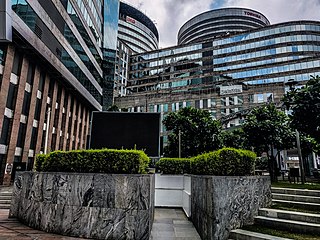
GSDP of Haryana state was US$85 billion in 2016-17, which had grown at 12.96% CAGR between 2012–17, boosted by the fact that this state on DMIC in NCR contributes 7% of India's agricultural exports and 60% of India's Basmati rice export, with 7 operational SEZs and additional 23 formally approved SEZs also produces India's 67% of passenger cars, 60% of motorcycles, 50% of tractors and 50% of the refrigerators, which places Haryana on 14th place on the list of Indian states and union territories by GDP behind only much bigger states that are significantly larger in both area and population. As per Nov 2016 data, Gurugram ranks number 1 in India in IT growth rate and existing technology infrastructure, and number 2 in startup ecosystem, innovation and livability.
Bisahan is a village in the Beri tehsil of Jhajjar district of Haryana, India. The village lies roughly 5 kilometres (3.1 mi) from the town of Beri.


