Dunhong

Last updated

The Dunhong (Chinese :敦薨) mountain, according to the Shanhaijing , is a mountain of the Tian Shan range.

Chinese language family of languages

Chinese is a group of related, but in many cases not mutually intelligible, language varieties, forming the Sinitic branch of the Sino-Tibetan language family. Chinese is spoken by the Han majority and many minority ethnic groups in China. About 1.2 billion people speak some form of Chinese as their first language.

Tian Shan system of mountain ranges located in Central Asia

The Tian Shan, also known as the Tengri Tagh, meaning the Mountains of Heaven or the Heavenly Mountain, is a large system of mountain ranges located in Central Asia. The highest peak in the Tian Shan is Jengish Chokusu, at 7,439 metres (24,406 ft) high. Its lowest point is the Turpan Depression, which sits at 154 m (505 ft) below sea level.

This mountain has been proposed to be the homeland of the Yuezhi. According to archaeologist Lin Meicun (林梅村), this is the Dunhuang (Chinese :燉煌) mentioned in the Shiji by Sima Qian, which states that:

Yuezhi ethnic group

The Yuezhi were an ancient Indo-European people first described in Chinese histories as nomadic pastoralists living in an arid grassland area in the western part of the modern Chinese province of Gansu, during the 1st millennium BC. After a major defeat by the Xiongnu in 176 BC, the Yuezhi split into two groups migrating in different directions: the Greater Yuezhi and Lesser Yuezhi.

Sima Qian Chinese historian and writer

Sima Qian was a Chinese historian of the early Han dynasty. He is considered the father of Chinese historiography for his Records of the Grand Historian, a Jizhuanti-style general history of China, covering more than two thousand years from the Yellow Emperor to his time, during the reign of Emperor Wu of Han, a work that had much influence for centuries afterwards on history-writing not only in China, but in Korea, Japan and Vietnam as well. Although he worked as the Court Astrologer, later generations refer to him as the Grand Historian for his monumental work; a work which in later generations would often only be somewhat tacitly or glancingly acknowledged as an achievement only made possible by his acceptance and endurance of punitive actions against him, including imprisonment, castration, and subjection to servility.

The Yuezhi originally lived in the area between the Qilian Shan and Dunhuang, but after they were defeated by the Xiongnu they moved far away to the west, beyond Dayuan [the Ferghana Valley], where they attacked and conquered the people of Daxia [Bactria] ... [1]

Lin Meicun argued that the present Dunhuang (Chinese :敦煌, 燉煌), a Gansu oasis town, was founded around 111 BC, that is, later than the report of Zhang Qian on the Yuezhi (126 BC). Therefore the Dunhuan referred to in the Shiji cannot be the city currently bearing that name, and is most likely an oasis near Turpan.

Dunhuang County-level city in Gansu, Peoples Republic of China

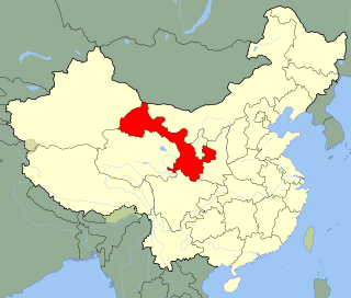
Dunhuang is a county-level city in northwestern Gansu Province, Western China. The 2000 Chinese census reported a population of 187,578 in this city. Dunhuang was a major stop on the ancient Silk Road and is best known for the nearby Mogao Caves. It has also been known at times as Shazhou and, in Uyghur, Dukhan.

Gansu Province

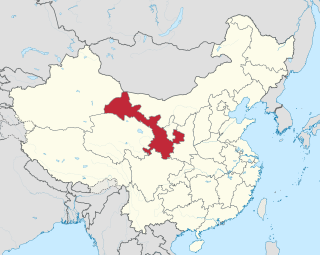
Gansu is a province of the People's Republic of China, located in the northwest of the country.

Zhang Qian imperial envoy to the world outside of China in the 2nd century BC

Zhang Qian was a Chinese official and diplomat who served as an imperial envoy to the world outside of China in the late 2nd century BC during the Han dynasty. He was the first official diplomat to bring back reliable information about Central Asia to the Chinese imperial court, then under Emperor Wu of Han, and played an important pioneering role in the Chinese colonization and conquest of the region now known as Xinjiang.

Place names such Dunhong and Qilian may have had Indo-European etymologies, from at two possible sources. For example:

Tocharian languages extinct branch of the Indo-European language family

Tocharian, also spelled Tokharian, is an extinct branch of the Indo-European language family. It is known from manuscripts dating from the 6th to the 8th century AD, which were found in oasis cities on the northern edge of the Tarim Basin. The discovery of these languages in the early 20th century contradicted the formerly prevalent idea of an east–west division of the Indo-European language family on the centum–satem isogloss, and prompted reinvigorated study of the family. Identifying the authors with the Tokharoi people of ancient Bactria (Tokharistan), early authors called these languages "Tocharian". Although this identification is now generally considered mistaken, the name has remained.

According to a Tang Dynasty commentator on the Shiji, qilian was a Xiongnu word for "sky" – although Xiongnu may also have borrowed the word from an Indo-European language.

Related Research Articles

Bactria Historical region in Central Asia

Bactria ; or Bactriana was a historical region in Central Asia. Bactria proper was north of the Hindu Kush mountain range and south of the Amu Darya river, covering the flat region that straddles modern-day Afghanistan, Tajikistan, Uzbekistan, and parts of Northern Pakistan. More broadly Bactria was the area north of the Hindu Kush, west of the Pamirs and south of the Tian Shan with the Amu Darya flowing west through the center.

Wusun A Nomadic steppe people who between the 2nd century BC and the 9th century AD according to Chinese historians lived in the Tarim basin the li Valley and the Pamir Mountains respectively.

The Wusun were an Indo-European semi-nomadic steppe people mentioned in Chinese records from the 2nd century BCE to the 5th century CE.

Saka historic ethnic group

Saka, Śaka, Shaka or Saca(Persian: oldSakā,mod. ساکا; Sanskrit: Śaka; Ancient Greek: Σάκαι, Sákai; Latin: Sacae; Chinese: 塞, old *Sək, mod. Sāi) were a group of nomadic Iranian peoples who historically inhabited the northern and eastern Eurasian Steppe and the Tarim Basin.

Tarim Basin geographical area in asia, in the west of current China

The Tarim Basin is an endorheic basin in northwest China occupying an area of about 1,020,000 km2 (390,000 sq mi). Located in China's Xinjiang region, it is sometimes used synonymously to refer the southern half of the province, or Nanjiang, as opposed to the northern half of the province known as Dzungaria or Beijiang. Its northern boundary is the Tian Shan mountain range and its southern boundary is the Kunlun Mountains on the edge of the Tibetan Plateau. The Taklamakan Desert dominates much of the basin. The historical Uyghur name for the Tarim Basin is Altishahr (六域), which means "six cities" in Uyghur.

Hexi Corridor

Hexi Corridor (Chinese: 河西走廊; pinyin: Héxī Zǒuláng; Wade–Giles: Ho2-hsi1 Tsou3-lang2, Xiao'erjing: حْسِ ظِوْلاْ, IPA: /xɤ˧˥ɕi˥ tsoʊ˨˩˦lɑŋ˧˥/) or Gansu Corridor refers to the historical route in Gansu province of China. As part of the Northern Silk Road running northwest from the bank of the Yellow River, it was the most important route from North China to the Tarim Basin and Central Asia for traders and the military. The corridor is a string of oases along the northern edge of the Tibetan Plateau. To the south is the high and desolate Tibetan Plateau and to the north, the Gobi Desert and the grasslands of Outer Mongolia. At the west end the route splits in three, going either north of the Tian Shan or south on either side of the Tarim Basin. At the east end are mountains around Lanzhou before one reaches the Wei River valley and China proper.

Dayuan

Dayuan (Ta-yuan; Old Chinese reconstructed pronunciation: /dhaːts ʔwan/; Middle Chinese reconstructed pronunciation according to Edwin G. Pulleyblank: /daj ʔuan/; Chinese: 大宛; pinyin: Dàyuān; Wade–Giles: Ta4-yuan1; literally: 'Great Ionians') was a country in Ferghana valley in Central Asia, described in the Chinese historical works of Records of the Grand Historian and the Book of Han. It is mentioned in the accounts of the famous Chinese explorer Zhang Qian in 130 BCE and the numerous embassies that followed him into Central Asia. The country of Dayuan is generally accepted as relating to the Ferghana Valley, controlled by the Greek polis Alexandria Eschate (modern Khujand, Tajikistan).

Fergana Place in Fergana Region, Uzbekistan

Fergana, or Ferghana, is the capital of Fergana Region in eastern Uzbekistan. Fergana is about 420 km east of Tashkent, about 75 km west of Andijan, and less than 20 km from the Kyrgyzstan border.

Daxia

Daxia, Ta-Hsia, or Ta-Hia was apparently the name given in antiquity by the Han Chinese to Tukhara or Tokhara: the main part of Bactria, in what is now northern Afghanistan, and parts of southern Tajikistan and Uzbekistan.

Qilian Mountains mountain range

The Qilian Mountains, together with the Altyn-Tagh also known as Nan Shan, as it is to the south of Hexi Corridor, is a northern outlier of the Kunlun Mountains, forming the border between Qinghai and the Gansu provinces of northern China.

Kangju Ethnic group mentioned in Chinese history; probably the Sogdians

Kangju was the Chinese name of an ancient kingdom in Central Asia which became for a couple of centuries the second greatest power in Transoxiana after the Yuezhi. Its people, the Kāng were an Indo-European semi-nomadic people probably identical to the Iranian Sogdians or other Iranian groups closely related to them, such as the Asii.

Yancai

Yancai was the Chinese name of an ancient nomadic state centered near the Aral Sea during the Han dynasty period. They are generally considered to have been an Iranian people of the Sarmatian group. After becoming vassals of the Kangju in the 1st century BC, Yancai became known as Alanliao. Yancai is often connected to the Aorsi of Roman records, while Alanliao has been connected to the later Alans.

The Xunyu is the name of an ancient nomadic tribe which invaded China during legendary times. They are often identified as the Xiongnu.

Guifang was an ancient ethnonym for a northern people that fought against the Shang Dynasty. Chinese historical tradition identified the Guifang with the Rong, Xunyu, or Xiongnu peoples. This Chinese exonym combines gui and fang, a suffix referring to "non-Shang or enemy countries that existed in and beyond the borders of the Shang polity." The sinologist Herrlee Glessner Creel translated Guifang as "Demon Territory".

Greco-Bactrian Kingdom realm

The Greco-Bactrian Kingdom was – along with the Indo-Greek Kingdom – the easternmost part of the Hellenistic world, covering Bactria and Sogdiana in Central Asia from 250 to 125 BC. It was centered on the north of present-day Afghanistan. The expansion of the Greco-Bactrians into present-day eastern Afghanistan and Pakistan from 180 BC established the Indo-Greek Kingdom, which was to last until around 10 AD.

War of the Heavenly Horses

The War of the Heavenly Horses was a military conflict fought in 104 BC and 102 BC between the Han dynasty and Dayuan. Emperor Wu of Han had received reports of tall and powerful horses in the possession of Dayuan which could aid the Han army in their fight against the nomadic Xiongnu. Dayuan - probably ethnic Greeks - refused to offer them enough horses along with a series of conflicts and mutual disrespect resulted in the death of the Han ambassador and the confiscation of the gold sent as payment for the horses.

Dunhuang or Dun-Huang is a city in Gansu, China.

References

  1. Watson, Burton. Trans. 1993. Records of the Grand Historian of China: Han Dynasty II. Translated from the Shiji of Sima Qian. Chapter 123: "The Account of Dayuan," Columbia University Press. Revised Edition. ISBN   0-231-08166-9; ISBN   0-231-08167-7 (pbk.), p. 234.