
The Super Continental was a transcontinental Canadian passenger train operated by the Canadian National Railway from 1955 until 1977, when Via Rail took over the train and ran it until it was cancelled in 1981. Service was restored in 1985 but was again eliminated in 1990. The original CN train had a Montreal–Ottawa–Toronto-Winnipeg–Saskatoon–Edmonton–Jasper–Vancouver routing with daily service.
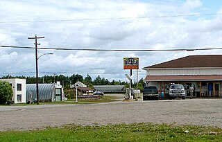
Foleyet is an unincorporated community in the Unorganized North Part of Sudbury District in Northeastern Ontario, Canada, midway between Chapleau and Timmins on Highway 101. The town was created during the construction of the Canadian Northern Railway (CNR) through the area in the early years of the 20th century.

The Kapuskasing River is a river in the James Bay drainage basin in Cochrane District and Algoma District in northeastern Ontario, Canada. The river is a left tributary of the Mattagami River.
Gibson Lake is a lake in geographic Hutton Township in Greater Sudbury in Northeastern Ontario, Canada. It is in the Great Lakes Basin and is on the Vermilion River, which flows via the Spanish River to Lake Huron. The Canadian National Railway transcontinental main line, used by freight traffic and the Canadian passenger train, travels along the eastern shore of the lake.
Elsas is an unincorporated place and railway point in geographic Kapuskasing Township, in the Unorganized North part of Algoma District in northeastern Ontario, Canada. It is on the Canadian National Railway transcontinental railway main line between the railway points of Agate to the west and Oatland to the east, and is the location of Elsas railway station, a stop for Via Rail transcontinental Canadian trains. The station and settlement are on the northern shore of Kapuskasing Lake, the source of the Kapuskasing River.
Kapuskasing Lake is a lake in Algoma District and Sudbury District in northeastern Ontario, Canada. It is in the James Bay drainage basin and is the source of the Kapuskasing River. The majority of the lake is in geographic Kapuskasing Township, Algoma District, with just the southern tip in geographic Sherlock Township, Sudbury District.
Agate is an unincorporated place and railway point in geographic Kapuskasing Township, in the Unorganized North part of Algoma District in northeastern Ontario, Canada. It is on the Canadian National Railway transcontinental railway main line between the railway points of Dunrankin to the west and Elsas to the east, has a passing track, and is passed but not served by Via Rail transcontinental Canadian trains. The place is just northwest of Kapuskasing Lake, the source of the Kapuskasing River.
Peterbell is an unincorporated place and dispersed rural community in geographic Coderre Township, in the Unorganized North part of Algoma District in northeastern Ontario, Canada. It is on the Canadian National Railway transcontinental railway main line between the railway points of Argolis to the west and Dunrankin to the east, has a passing track, and is passed but not served by Via Rail transcontinental Canadian trains. The place is on the Missinaibi River, a tributary of the Moose River. It is named for Peter Bell, who was in charge of the Hudson's Bay Company Superior District from 1866 to 1895.
The Dunrankin River is a river in Algoma District and Sudbury District in northeastern Ontario, Canada. It is in the James Bay drainage basin, begins at Upper Dunrankin Lake and is a left tributary of the Kapuskasing River.
The East Dunrankin River is a river in Algoma District and Sudbury District in northeastern Ontario, Canada. It is in the James Bay drainage basin, and is a right tributary of the Dunrankin River.
The Kirkwall River is a river in Algoma District and Sudbury District in northeastern Ontario, Canada. It is in the James Bay drainage basin, and is a right tributary of the Dunrankin River.
The Nemegosenda River is a river in Algoma District and Sudbury District in northeastern Ontario, Canada. It is in the James Bay drainage basin, and is a right tributary of the Kapuskasing River.
Oatland is an unincorporated place and railway point in geographic Lougheed Township, in the Unorganized North part of Algoma District in northeastern Ontario, Canada. It is on the Canadian National Railway transcontinental railway main line between the railway points of Elsas to the west and Missonga to the east, has a passing track, and is passed but not served by Via Rail transcontinental Canadian trains. Oatland is on Shiners Creek, a right tributary of the Nemegosenda River.
Missonga is an unincorporated place and railway point in geographic Shenango Township, in the Unorganized North part of Sudbury District in northeastern Ontario, Canada. It is on the Canadian National Railway transcontinental railway main line between the railway point of Oatland to the west and the dispersed rural community of Shawmere to the east, has a railway siding, and is passed but not served by Via Rail transcontinental Canadian trains. Missonga is on Shenango Lake, at a point where Mishionga Creek leaves the lake; Mishionga Creek is a left tributary of the Shawmere River.
Argolis is an unincorporated place and railway point in geographic Hayward Township, in the Unorganized North part of Algoma District in northeastern Ontario, Canada. It is on the Canadian National Railway transcontinental railway main line between the railway points of Fire River to the west and Peterbell to the east, has a passing track, and is passed but not served by Via Rail transcontinental Canadian trains. Argolis is on an unnamed right tributary of the Greenhill River, itself a tributary of the Missinaibi River, and is named for the Greek region of Argolis.
The Greenhill River is a river in Algoma District in northeastern Ontario, Canada. It is in the James Bay drainage basin, and is a left tributary of the Missinaibi River.
The Fire River is a river in Algoma District in northeastern Ontario, Canada. It is in the James Bay drainage basin, and is a left tributary of the Missinaibi River.
Dishnish is an unincorporated place and railway point in geographic Legge Township, in the Unorganized North part of Algoma District in northeastern Ontario, Canada. It is on the Canadian National Railway transcontinental railway main line between the Dispersed Rural Community of Minnipuka to the west and the railway point of Fire River to the east, has a passing track, and is passed but not served by Via Rail transcontinental Canadian passenger trains. The place is on Dishnish Creek, a left tributary of the Fire River.
Minnipuka is an unincorporated place and Dispersed Rural Community in geographic Marjorie Township, in the Unorganized North part of Algoma District in northeastern Ontario, Canada. It is on the Canadian National Railway transcontinental railway main line between the railway points of Neswabin to the west and Dishnish to the east, has a passing track, and is passed but not served by Via Rail transcontinental Canadian passenger trains. The place is on the east side of Minnipuka Lake, part of the Goat River system.
The Canadian National Railway Alderdale Subdivision was a railway line in Northeastern Ontario, Canada. It originally opened in 1915 as a part of the Canadian Northern Railway's transcontinental mainline. It connected Brent in the east with Capreol in the west. At Capreol it formed the eastern component of an east-west-south wye junction. The line's divisional point was at Alderdale.
