
Elbasan County is one of the 12 counties of Albania. The population at the 2011 census was 295,827, in an area of 3199 km². Its capital is the city Elbasan.
Gülüç is a town in Zonguldak province, Turkey, on the shore of the Black Sea.

Diyarbakır Province is a province in southeastern Turkey. The province covers an area of 15,355 km2 and its population is 1,528,958. The provincial capital is the city of Diyarbakır.

The Thracian Sea is a sea that is part of the Aegean Sea and forms the northernmost point of the sea. Regions surrounding the sea are Macedonia and Thrace as well as northwestern Turkey. The entire stretch of the sea lies north of the 40th parallel. The length from east to west is from 23°E to about 25.8°E or from the Strymonian Gulf east to the northernmost part of the Gallipoli peninsula and the width from north to south is about 40.25°N to 41°N or from the Dardanelles north to the boundary between the Xanthi and the Rhodope regional units. Islands includes Thasos and Samothrace in Greece and Gökçeada and Bozcaada in Turkey. The bays and gulfs includes the Ierissian Gulf to the southwest, the Strymonian Gulf where the Strymon River empties, the Kavala Gulf and the Saros Gulf in Turkey. Rivers emptying into this portion of the gulf include the Nestos and the Evros/Meriç. The famous thermal springs are Loutra Eleftheron in Kavala.

Dalıqaya is a village in the Quba Rayon of Azerbaijan. The village forms part of the municipality of Zıxır.

Chaoyang County is a county of northwestern Liaoning province, China. It is under the administration of Chaoyang city.
Kavrakirovo is a village in Petrich Municipality, in Blagoevgrad Province, Bulgaria.

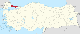
Kozlu is a ilçe (district) in the central part of Zonguldak Province, Turkey. It is situated at the coast of Black Sea. At 41°26′N31°45′E it is west of Zonguldak. But it is almost merged to Zonguldak. The population of Kozlu is 34739. as of 2010. It is a relatively a new town founded after coal mines around Zonguldak were discovered. In 1926 the coal company of Kozlu was founded and Kozlu flourished. In 1936 together with the other mines around Kozlu company was bought by the government. At the present Kozlu is a typical mining town.
İspatlı, Alanya is a village in the District of Alanya, Antalya Province, Turkey.
Teberük is a village in the district of Vezirköprü, Samsun Province, Turkey.
Öğürlü is a village in the Vezirköprü, Samsun Province, Turkey.
Yağınözü is a village in the Vezirköprü, Samsun Province, Turkey.
Sırbaşmak is a village in the Vezirköprü, Samsun Province, Turkey.
Dolayüz is a village in the District of Mudurnu, Bolu Province, Turkey. As of 2010 it had a population of 231 people.
İstanbul is a Turkish province divided into three electoral districts of the Grand National Assembly of Turkey. It elects eighty-five members of parliament (deputies) to represent the province of the same name for a four-year term by the D'Hondt method, a party-list proportional representation system.
Büyüktekke is a village in Alaplı District, Zonguldak Province, Turkey.
Gökhasan is a village in Alaplı District, Zonguldak Province, Turkey.
Güdüllü is a village in Çaycuma District, Zonguldak Province, Turkey.
Örenyeri is a village in the District of Kastamonu, Kastamonu Province, Turkey.


