Dutch architecture in Semarang

Last updated
Watchtower (customs house?) and bandstand on the river in Semarang COLLECTIE TROPENMUSEUM Gezicht op de rivier muziektent en uitkijktoren van Semarang TMnr 10014752.jpg
Watchtower (customs house?) and bandstand on the river in Semarang
NIS Headquarters (now Lawang Sewu) COLLECTIE TROPENMUSEUM Het hoofdkantoor van de Nederlandsch-Indische Spoorweg Maatschappij (NIS) in Semarang TMnr 10032316.jpg
NIS Headquarters (now Lawang Sewu)
Nillmij Office Building Kantoorgebouw Nillmij - Nillmij Office Building (4751585814).jpg
Nillmij Office Building

During the colonial period many significant examples of Dutch architecture were built in Semarang, Indonesia.

Contents

Control of Semarang was given to the Dutch East India Company (VOC) as a part of a debt payment by Sunan Amangkurat II in 1678 and established as area in 1682 Dutch. On 5 October 1705, Semarang officially became a VOC city when Susuhunan Pakubuwono I made a deal to give extensive trade rights to the VOC in exchange for wiping out Mataram's debt. The VOC, and later, the Dutch East Indies government, established tobacco plantations in the region and built roads and railroads, making Semarang an important colonial trading centre. [ citation needed ]

The presence of a Dutch based creole in the area is due to the fact that creole mix language called Javindo that developed. [1]

The Japanese military occupied the city, along with the rest of Java, in 1942, during the Pacific War of World War II. After Indonesian independence in 1945, Semarang became the capital of Central Java province.

City planning of Semarang during Dutch colonial era


The era of Classical Indische Town (1678–1870)


The city included a Muslim area called Kauman, a Chinese quarter, and a Dutch fortress. The fortress had a pentagonal form with only one gate in the south and five monitoring towers to protect the Dutch settlement from rebellion actions, segregating the spaces between Dutch settlement and other areas. [2] The Dutch quarter was considered the city of Semarang by the Dutch while the other ethnic settlements were considered as villages outside the city boundary.

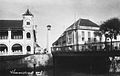
Known as de Europeeshe Buurt, Semarang was built in classical European style with a church located in the centre, wide boulevards and streets skirted by beautiful villas. [3] According to Purwanto (2005), [4] the urban and architectural form of this settlement is very similar to the design principles applied in many Dutch cities and consideration of urban beautification.

Due to the long and costly Java War, there was not much of funding from the Dutch East Indies government for the development of Semarang. The majority of land was used for rice fields and the only small improvements were made around the fortress.

Although less populous than Jakarta and Surabaya, Semarang is a planned city with urban activities concentrated along the river. The settlement was linked to a market where different ethnic groups met to trade. The existence of the market, in the later years, become a primary element and a generator of urban economic growth. [5]

An important influence on urban growth was the Great Mail Road project in 1847, which connected all the cities in northern coast of Central and East Java and made Semarang the trade centre of agricultural production. [6] The project was soon followed by the development of the Netherlands Indies Railway and the connecting roads into the inner city of Semarang at the end of 19th century. [5] Colombijn (2002) [6] This marked the development as the shift of urban functions, from the former river orientation to facing the roads.

The growth of the modern city (1870–1922)

Aerial picture of Old Semarang (1920s) COLLECTIE TROPENMUSEUM Luchtfoto van Semarang rechtsboven N.I.S. station TMnr 10014760.jpg
Aerial picture of Old Semarang (1920s)

The Dutch East Indies' mail and railway projects improved communication and transportation, bringing an economic boom to the city in the 1870s. Hospitals, churches, hotels, and mansions were built along the new main roads of Mataram Street, Bojongscheweg, and Pontjolscheweg. [3] The Javanese quarters of town known as kampongs grew increasingly densely populated, reaching as many as 1000 inhabitants per hectare and degrading living conditions. [7] Mortality remained high into the early 20th century, with newcomers, overcrowding, and poor hygiene triggering cholera and tuberculous outbreaks. [8] Dysentery, typhoid, and malaria were also rife. [9] The city doctor Willem T. de Vogel advocated strenuously for reducing overcrowding and improving living conditions by extending Semarang into the less malarial hill country to its south; [10] his fellow councilman Hendrik Tillema had campaigned on a platform of combatting malaria and joined De Vogel's scheme, broadening it into a "village improvement" (Dutch : kampongverbetering) movement. [7] Purchasing land in the heights with their own money, the two men and some friends passed it on to the city with an initial zoning plan by KPC de Bazel in 1907 but could never convince a majority of the council to support its development. [9] [10] Changing tack, Tillema then worked to improve the existing kampongs in the city's malarial districts by improving drainage and providing more sanitary public toilets and public housing. [7]

A decade later, the town approved Thomas Karsten's revised plan for the area, using it to build larger villas for the Dutch and wealthy Chinese and Javanese rather than allowing its use by the poor. [9] [10] [11] This area became known as Candi Baru (Dutch : Nieuw Tjandi) and forms the core of the present-day Candisari District. Although it remained highly stratified by class, [3] Candi Baru had less ethnic segregation than the older area of town and incorporated public squares, athletic facilities, and places for public bathing and washing that could be used communally. [12] With most work remaining in the lower city and transportation slow or expensive, few of the lower classes were interested in moving to the district [10] but it set a pattern that was followed with three more successful housing plans between 1916–1919. The population grew by 55%, adding 45,000 Javanese, 8500 Chinese, and 7000 Europeans. Karsten's approach to town planning emphasized its aesthetic, practical, and social requirements articulated in economic terms rather than purely racial ones. [12]

Driven by economic growth and spatial city planning, the city had doubled in size and expanded to the south by the 1920s, creating a nucleus of a metropolis where multi-ethnic groups lived and traded in the city. The villages in the suburbs such as Jomblang and Jatingaleh steadily became the satellite towns of Semarang, more populated with a bigger market area. Before the invasion of Japan in 1942, Semarang had already become the capital of Central Java Province, as the result of trade and industrial success and spatial planning. [3]

Buildings

Significant buildings include:

Related Research Articles

<span class="mw-page-title-main">Central Java</span> Province of Indonesia

Central Java is a province of Indonesia, located in the middle of the island of Java. Its administrative capital is Semarang. It is bordered by West Java in the west, the Indian Ocean and the Special Region of Yogyakarta in the south, East Java in the east, and the Java Sea in the north. It has a total area of 32,800.69 km2, with a population of 36,516,035 at the 2020 Census making it the third-most populous province in both Java and Indonesia after West Java and East Java. The official estimate as at mid 2021 was 36,742,501. The province also includes the island of Nusakambangan in the south, and the Karimun Jawa Islands in the Java Sea.

<span class="mw-page-title-main">Semarang</span> Capital of Central Java, Indonesia

Semarang is the capital and largest city of Central Java province in Indonesia. It was a major port during the Dutch colonial era, and is still an important regional center and port today. The city has been named as the cleanest tourist destination in Southeast Asia by the ASEAN Clean Tourist City Standard (ACTCS) for 2020–2022.

<span class="mw-page-title-main">Mataram Sultanate</span> Kingdom on the island of Java (1586–1755)

The Sultanate of Mataram was the last major independent Javanese kingdom on the island of Java before it was colonised by the Dutch. It was the dominant political force radiating from the interior of Central Java from the late 16th century until the beginning of the 18th century.

<span class="mw-page-title-main">Catholic Church in Indonesia</span> Overview of the role of the Catholic Church in Indonesia

The Catholic Church in Indonesia is part of the worldwide Catholic Church, under the spiritual leadership of the pope in Rome. Catholicism is one of the six approved religions in Indonesia, the others being Islam, Protestantism, Hinduism, Buddhism, and Confucianism. According to official figures, Catholics made up 3.12 percent of the population in 2018. The number of Catholics is, therefore, more than 8.3 million. Indonesia is primarily Muslim, but Catholicism is the dominant faith in certain areas of the country.

<span class="mw-page-title-main">Architecture of Indonesia</span> Overview of the architecture in Indonesia

The architecture of Indonesia reflects the diversity of cultural, historical and geographic influences that have shaped Indonesia as a whole. Invaders, colonizers, missionaries, merchants and traders brought cultural changes that had a profound effect on building styles and techniques.

Javindo, also known by the pejorative name Krontjong, was a Dutch-based creole language spoken on Java, Indonesia. The name Javindo is a portmanteau of Java and Indo, the Dutch word for a person of mixed Indonesian and Dutch descent. This contact language developed from communication between Javanese-speaking mothers and Dutch-speaking fathers in Indo families. Its main speakers were Indo-Eurasian people. Its grammar was based on Javanese, and its vocabulary was based on the Dutch lexicon but pronounced in a Javanese manner.

Herman Thomas Karsten was a Dutch engineer who gave major contributions to architecture and town planning in Indonesia during Dutch colonial rule. Most significantly he integrated the practice of colonial urban environment with native elements; a radical approach to spatial planning for Indonesia at the time. He introduced a neighborhood plan for all ethnic groups in Semarang, built public markets in Yogyakarta and Surakarta, and a city square in the capital Batavia. Between 1915 and 1941 he was given responsibility for planning 12 out of 19 municipalities in Java, 3 out of 9 towns in Sumatra and a town in Kalimantan. He received official recognition from both the government through his appointment to the colony's major Town Planning Committee and by the academic community with his appointment to the position of Lecturer for Town Planning at the School of Engineering at Bandung. He died in an internment camp near Bandung in 1945 during the Japanese occupation of Indonesia.

<span class="mw-page-title-main">Demak Regency</span> Regency of Indonesia

Demak is a regency located in the Indonesian province of Central Java, on northern coast of the island. It is bordered by Jepara regency and the Java Sea to the north, Kudus and Grobogan regencies to the east, Grobogan and Semarang regencies to the south, while to the west are Semarang Regency and the city of Semarang, to which the districts of Mranggen and Sayung are essentially suburban. The regency covers an area of 897.43 km2 (346.50 sq mi) and had a population of 1,055,579 at the 2010 Census and 1,203,956 at the 2020 Census. It was originally the centre of the Demak Sultanate, once a dominant power in the region. Due to its strong relation with the spread of Islam in Java and the Wali Sanga, it is sometimes referred to with the nickname Kota Wali.

<span class="mw-page-title-main">Company rule in the Dutch East Indies</span> Early Dutch colonization in the East Indies.

Company rule in the Dutch East Indies began when the Dutch East India Company appointed the first governor-general of the Dutch East Indies in 1610, and ended in 1800 when the bankrupt company was dissolved and its possessions were nationalized as the Dutch East Indies. By then it exerted territorial control over much of the archipelago, most notably on Java.

<span class="mw-page-title-main">Cipto Mangunkusumo</span>

Cipto Mangunkusumo or Tjipto Mangoenkoesoemo was a prominent Indonesian independence leader and Sukarno's political mentor. Together with Ernest Douwes Dekker and Soewardi Soerjaningrat he was one of the three founders of the influential Indische Party, a political party disseminating the idea of self-government of the Dutch East Indies. After the party was labeled subversive by colonial court of law in 1913, he and his fellow IP leaders were exiled to the Netherlands.

<span class="mw-page-title-main">Colonial architecture of Indonesia</span>

The colonial architecture of Indonesia refers to the buildings that were created across Indonesia during the Dutch colonial period, during that time, this region was known as the Dutch East Indies. These types of colonial era structures are more prevalent in Java and Sumatra, as those islands were considered more economically significant during the Dutch imperial period. As a result of this, there is a large number of well preserved colonial era buildings that are still densely concentrated within Indonesian cities in Java and Sumatra to this day.

<span class="mw-page-title-main">Siege of Batavia</span>

The siege of Batavia was a military campaign led by Sultan Agung of Mataram to capture the Dutch port-settlement of Batavia in Java. The first attempt was launched in 1628, and the second in 1629; both were unsuccessful.

<span class="mw-page-title-main">French and British interregnum in the Dutch East Indies</span> French and British colonial administration in the Dutch East Indies

The French and British interregnum in the Dutch East Indies were a relatively short period of French and then British interregnum in the Dutch East Indies that took place between 1806 and 1816. The French ruled between 1806 and 1811, while the British took over for 1811 to 1816 and transferred its control back to the Dutch in 1816.

<span class="mw-page-title-main">New Indies architecture</span> Architectural style in Dutch East Indies

New Indies Style is a modern architectural style used in the Dutch East Indies between the late 19th century through pre-World War II 20th century. New Indies Style is basically early modern (western) architecture, which applies local architectural elements such as wide eaves or prominent roof as an attempt to conform with the tropical climate of Indonesia.

<span class="mw-page-title-main">Kologdam Building</span>

The Kologdam Building is a historic building in Bandung, Indonesia. In the 1920s, Kologdam Building was the main building for the Bandung Jaarbeurs, a complex of buildings and pavilions where annual trade was held. The building is currently a military complex for the Education and Training Command Headquarters of the Siliwangi Division.

<span class="mw-page-title-main">Indies Empire architecture</span> Architectural style in Dutch East Indies

Indies Empire style is an architectural style that flourished in the colonial Dutch East Indies between the middle of the 18th century and the end of the 19th century. The style is an imitation of neoclassical Empire Style which was popular in mid-19th-century France. Conformed to the tropical setting of Indonesia, the style became known in the Dutch East Indies as Indies Empire style.

<span class="mw-page-title-main">Fort Vastenburg</span>

Fort Vastenburg, also Fort Surakarta, is an 18th-century Dutch fort located in Gladak, Surakarta, Central Java, Indonesia. A landmark of Surakarta, the fort faces polemics related with multiple owners claiming different parts of the fort. As a result, the fort remains abandoned and threatened to be demolished by various private parties claiming the fort's ownership.

<span class="mw-page-title-main">Semarang Residency</span>

Semarang Residency was an administrative subdivision (Residency) of the Dutch East Indies located on the northern coast of Central Java and named after its capital city Semarang. It existed from 1818 to 1942, although its borders were changed many times during that period.

<span class="mw-page-title-main">Willem Thomas de Vogel</span> Dutch East Indies public health official

Willem Thomas de Vogel was a colonial Dutch doctor and official who established the Department of Public Health in the Dutch East Indies.

<span class="mw-page-title-main">Hendrik Tillema</span>

Hendrik Freerk Tillema was a colonial Dutch official, writer, and hygienist in the Dutch East Indies.

References

  1. De Gruiter, Miel. "Javindo, a contact language in pre-war Semarang". (Peter Bakker & Maarten Mous. Mixed Languages: 15 Case Studies in Language Intertwining. Amsterdam: IFOTT. 1994.) pp. 151–159.
  2. Purwanto, L. M. F. (2005). Kota Kolonial Lama Semarang. Dimensi Teknik Arsitektur, 33(1), 27-33
  3. 1 2 3 4 Pratiwo. (2005). The City Planning of Semarang 1900–1970. In F. Colombijn, M. Barwegen, P. Basundoro & J. A. Khusyairi (Eds.), Old City, New City: The History of the Indonesian City Before and After Independence. Yogyakarta: Penerbit Ombak.
  4. Purwanto, L. M. F. (2005). Kota Kolonial Lama Semarang. Dimensi Teknik Arsitektur, 33(1), 27-33.
  5. 1 2 Nas, P. J. M., & Pratiwo. (2002). Java and De Groote Postweg, La Grande Route, the Great Mail Road, Jalan Raya Pos’. Bijdragen tot de Taal-, Land-en Volkenkunde, 158(4), 707–725.
  6. 1 2 Colombijn, F. (2002). Introduction; On the road. Bijdragen tot de Taal-, Land-en Volkenkunde, 158(4), 595-617.
  7. 1 2 3 Cobban, J.L. (1993), "Public Housing in Colonial Indonesia, 1900–1940", Modern Asian Studies, vol. 27, no. 4, pp. 871–896.
  8. Silver, C. (2008), Planning the Megacity: Jakarta in the Twentieth Century, Psychology Press.
  9. 1 2 3 Snijders, Emilius Paulus (10 March 1953), "Hoofdartikelen: Dr. W. Th. de Vogel 90 Jaar Terugblik op een Rijk Leven" (PDF), Nederlands Tijdschrift voor Geneeskunde, vol. 97, no. 12, pp. 714–717. (Dutch)
  10. 1 2 3 4 Van Roosmalen, Pauline Katherina Maria (2017), "Modern Indisch Town Planning", The Life and Work of Thomas Karsten, Amsterdam: Architectura & Natura Press, pp. 265–303.
  11. Winckel, Charles Willem Frederik (19 March 1955), "Personalia: In Memoriam Dr. W. Th. de Vogel" (PDF), Nederlands Tijdschrift voor Geneeskunde, vol. 99, no. 12, pp. 899–900. (Dutch)
  12. 1 2 Cote, J. (2004). Colonial designs: Thomas Karsten and the planning of urban Indonesia. Imprint, 2004, 01-01.