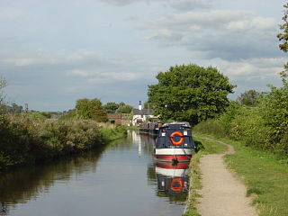
The Trent and Mersey Canal is a 93+1⁄2-mile (150 km) canal in Derbyshire, Staffordshire and Cheshire in north-central England. It is a "narrow canal" for the vast majority of its length, but at the extremities to the east of Burton upon Trent and north of Middlewich, it is a wide canal.
The River Dane is a tributary of the River Weaver that originates in the Peak District area of England. The name of the river is probably from the Old Welsh dafn, meaning a "drop or trickle", implying a slow-moving river.

The River Weaver is a river, navigable in its lower reaches, running in a curving route anti-clockwise across west Cheshire, northern England. Improvements to the river to make it navigable were authorised in 1720 and the work, which included eleven locks, was completed in 1732. An unusual clause in the enabling Act of Parliament stipulated that profits should be given to the County of Cheshire for the improvement of roads and bridges, but the navigation was not initially profitable, and it was 1775 before the first payments were made. Trade continued to rise, and by 1845, over £500,000 had been given to the county.

The National Waterways Museum (NWM) is in Ellesmere Port, Cheshire, England, at the northern end of the Shropshire Union Canal where it meets the Manchester Ship Canal. The museum's collections and archives focus on the Britain's navigable inland waterways, including its rivers and canals, and include canal boats, traditional clothing, painted canal decorative ware and tools. It is one of several museums and attractions operated by the Canal & River Trust, the successor to The Waterways Trust.

The Louth Navigation was a canalisation of the River Lud. It ran for 11 miles (18 km) from Louth in Lincolnshire, England, to Tetney Haven, at the mouth of the Humber. It was authorised by Act of Parliament in 1763 and completed in 1770, under the supervision of the engineer John Grundy Jr. and then by James Hogard. Eight locks were required to overcome the difference in altitude, six of which were constructed with sides consisting of four elliptical bays.

Snakeholme Lock is a brick chamber canal lock on the Driffield Navigation, in the East Riding of Yorkshire, England. It is notable in being a staircase lock, but only the upper lock is still used. It was designated Grade II in 1986.
Stamford Canal, now disused, is one of the earliest post-Roman canals in England. It opened in 1670, around 100 years before the start of the Industrial Revolution which brought about the "golden age" for canals in Britain. Parts of the route can be traced on the ground, though only one lock survives intact. It was part of the Welland Navigation in Lincolnshire. First authorised in 1571, during the reign of Elizabeth I, construction did not start until 1664, under powers granted in 1620 and ratified by James I. It ran for 9.5 miles (15.3 km) from Stamford to Market Deeping and had 12 locks, two of which were on the river section at Deeping St James. No plans of its construction survive, although one of the locks was documented by a visiting water engineer in 1699. It contributed to the wealth of Stamford, allowing barley to be transported to the town for malting.

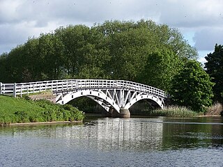
Twemlow is a civil parish, containing the village of Twemlow Green in the unitary authority of Cheshire East and the ceremonial county of Cheshire, England. According to the 2011 Official UK Census, the population of the entire civil parish was 192. Twemlow lies on the A535 road and the West Coast Mainline, which crosses the River Dane via the Grade-II-listed Twemlow Viaduct, built in brick by G. W. Buck, Engineer to Manchester and Birmingham Railway Company, in 1841.

The River Don Navigation was the result of early efforts to make the River Don in South Yorkshire, England, navigable between Fishlake and Sheffield. The Dutch engineer Cornelius Vermuyden had re-routed the mouth of the river in 1626, to improve drainage, and the new works included provision for navigation, but the scheme did not solve the problem of flooding, and the Dutch River was cut in 1635 to link the new channel to Goole. The first Act of Parliament to improve navigation on the river was obtained in 1726, by a group of Cutlers based in Sheffield; the Corporation of Doncaster obtained an Act in the following year for improvements to the lower river. Locks and lock cuts were built, and, by 1751, the river was navigable to Tinsley.
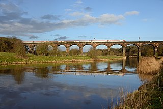
Dutton Viaduct is on the West Coast Main Line where it crosses the River Weaver and the Weaver Navigation between the villages of Dutton and Acton Bridge in Cheshire, England, not far from Dutton Horse Bridge. It is recorded in the National Heritage List for England as a Grade II* listed building.

The Sleaford Navigation was a 12.5 mile (20.1 km) canalisation of the River Slea in Lincolnshire, England, which opened in 1794. It ran from a junction with the River Witham, near Chapel Hill to the town of Sleaford through seven locks, most of which were adjacent to mills. Lack of finance meant that it stopped short of its intended terminus, but it gradually grew to be successful financially. The coming of the railways in 1857 led to a rapid decline, and it was officially abandoned by an act of Parliament in 1878, but remained open for a further three years. The lower part of it remained navigable until the 1940s, when it was blocked by a sluice.
The River Weaver Navigation Society is a waterway society concerned with the River Weaver, from Winsford to its confluence with the Manchester Ship Canal.
Holy Trinity Church, Northwich, is in the Castle district of Northwich, Cheshire, England. It is an active Anglican parish church in the deanery of Middlewich, the archdeaconry of Chester, and the diocese of Chester. Its benefice is united with that of St Luke, Winnington, Northwich. The church is recorded in the National Heritage List for England as a designated Grade II listed building.
Dutton Horse Bridge is a timber twin-span footbridge across part of the Weaver navigation, near the villages of Acton Bridge and Dutton in Cheshire, England. The bridge is located at SJ 583 767, between the Dutton Locks and Dutton Viaduct. It carries the towpath across a subsidiary channel used to regulate the water level, at the point where it rejoins the main river.
Acton Bridge is a civil parish in Cheshire West and Chester, England. It is mainly rural and contains the village of Acton Bridge. The parish is traversed by the River Weaver and Weaver Navigation in an east–west direction, the West Coast Main Line in a north–south direction, and the A49 road runs from northwest to southeast. It contains nine buildings that are recorded in the National Heritage List for England as designated listed buildings. Two of these are listed at Grade II*, and the other seven at Grade II. Most of the buildings are houses or farm buildings, but the list also includes a railway viaduct, a lock on the Weaver Navigation, and a guidepost.
Dutton is a civil parish in Cheshire West and Chester, England. It contains the village of Dutton, but is otherwise rural. Important transport links pass through the parish. The West Coast Main Line runs through in a north–south direction. Dutton Viaduct and the Weaver Junction are in the parish. The Trent and Mersey Canal runs through it in a northwest–southeast direction, and enters the south portal of the Preston Brook Tunnel. The A533 road traverses the parish in a similar direction. In the southern part of the parish, running east–west, is the River Weaver and the Weaver Navigation. Included in the parish are 22 buildings that are recorded in the National Heritage List for England as designated listed buildings. Some of the buildings are houses, and others are associated with the Trent and Mersey Canal and the Weaver Navigation.
Northwich is a civil parish and a town in Cheshire West and Chester, England. It contains 35 buildings that are recorded in the National Heritage List for England as designated listed buildings. Two of these are listed at Grade I, the highest grade, and the rest at the lowest grade, Grade II; none are listed at the middle grade, Grade II*. The River Dane joins the River Weaver and the Weaver Navigation within the parish. Also passing through the parish are the A533 road, the Trent and Mersey Canal, and a railway built by the Cheshire Lines Committee. Many of the listed buildings are associated with these features.
Barnton is a village and a civil parish in Cheshire West and Chester, England. It contains 11 buildings that are recorded in the National Heritage List for England as designated listed buildings, all of which are at Grade II. This grade is the lowest of the three gradings given to listed buildings and is applied to "buildings of national importance and special interest". Running through the parish are the Trent and Mersey Canal, which passes through two tunnels, and the River Weaver together with the Weaver Navigation. The majority of the listed buildings in the parish are associated with these transport links. Associated with the canal are four tunnel entrances, an airshaft, two mileposts, and a terrace of cottages. The Weaver Navigation contains Saltersford Locks, and its toll house. The other listed building is the village church, Christ Church.
Davenham is a civil parish in Cheshire West and Chester, England. It contains 28 buildings that are recorded in the National Heritage List for England as designated listed buildings. Other than the village of Davenham, the parish is rural, and most of the buildings in the list are domestic or related to farming. Running through the parish are the Trent and Mersey Canal, the River Weaver and the Weaver Navigation, and the West Coast Main Line; there are structures relating to all these in the list. The other listed buildings are the village church and associated structures, two public houses, and a memorial drinking fountain.
Daresbury was a Mersey flat that is now in a ruinous condition. It lies, partly submerged, in Sutton Lock on River Weaver in Cheshire, England. The lock and its contents are designated as a Scheduled Ancient Monument.


