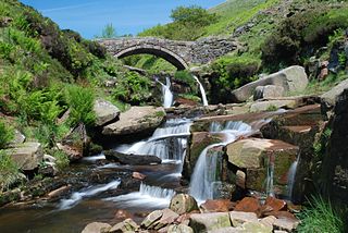
The River Dane is a tributary of the River Weaver that originates in the Peak District area of England. The name of the river is probably from the Old Welsh dafn, meaning a "drop or trickle", implying a slow-moving river.

The River Weaver is a river, navigable in its lower reaches, running in a curving route anti-clockwise across west Cheshire, northern England. Improvements to the river to make it navigable were authorised in 1720 and the work, which included eleven locks, was completed in 1732. An unusual clause in the enabling Act of Parliament stipulated that profits should be given to the County of Cheshire for the improvement of roads and bridges, but the navigation was not initially profitable, and it was 1775 before the first payments were made. Trade continued to rise, and by 1845, over £500,000 had been given to the county.

Teddington Lock is a complex of three locks and a weir on the River Thames between Ham and Teddington in the London Borough of Richmond upon Thames, England. Historically in Middlesex, it was first built in 1810.

Acton Bridge is a village and civil parish in Cheshire, England. Located within the unitary authority of Cheshire West and Chester on the River Weaver, it is near the Trent and Mersey Canal at approximately 53˚ 16′ N, 2˚ 36′ W. It has a population of 602, increasing to 631 at the 2011 Census. Acton Bridge is served by its own railway station, operated by London Northwestern.

The Runcorn Railway Bridge, Ethelfleda Bridge or Britannia Bridge crosses the River Mersey at Runcorn Gap between Runcorn and Widnes in Cheshire, England. It is alongside the Silver Jubilee Bridge. The bridge is recorded in the National Heritage List for England as a Grade II* Listed building.

Baddiley is a scattered settlement and civil parish in the unitary authority of Cheshire East and the ceremonial county of Cheshire, England. The civil parish also includes the north-western part of the village of Ravensmoor, as well as the small settlements of Baddiley Hulse, Batterley Hill, and parts of Gradeley Green and Swanley. According to the 2001 Census the parish had a total population of 226, increasing at the 2011 Census to 249.
Andrew Handyside and Company was an iron founder in Derby, England, in the nineteenth century.

The River Wey Navigation and Godalming Navigation together provide a 20-mile (32 km) continuous navigable route from the River Thames near Weybridge via Guildford to Godalming. Both waterways are in Surrey and are owned by the National Trust. The River Wey Navigation connects to the Basingstoke Canal at West Byfleet, and the Godalming Navigation to the Wey and Arun Canal near Shalford. The Navigations consist of both man-made canal cuts and adapted parts of the River Wey.

Dutton is a civil parish and village within the unitary authority of Cheshire West and Chester, in the ceremonial county of Cheshire, England, about two miles (3 km) east of Runcorn. Dutton is on the River Weaver and was home to Dutton Hall, built in 1513 and moved to Sussex in the 1930s. Dutton Viaduct, a viaduct of 20 arches, each 63 feet in span, and 60 feet high, carries the Grand Junction railway over Dutton Bottom, across the valley of the Weaver.

Smethwick Junction is the name of the canal junctions where the Birmingham Canal Navigations Main Line Canal from Birmingham splits into the BCN Old Main Line and the BCN New Main Line near to Smethwick, West Midlands, England.

The River Don Navigation was the result of early efforts to make the River Don in South Yorkshire, England, navigable between Fishlake and Sheffield. The Dutch engineer Cornelius Vermuyden had re-routed the mouth of the river in 1626, to improve drainage, and the new works included provision for navigation, but the scheme did not solve the problem of flooding, and the Dutch River was cut in 1635 to link the new channel to Goole. The first Act of Parliament to improve navigation on the river was obtained in 1726, by a group of Cutlers based in Sheffield; the Corporation of Doncaster obtained an Act in the following year for improvements to the lower river. Locks and lock cuts were built and by 1751 the river was navigable to Tinsley.
Rushall Junction is the southern limit of the Rushall Canal where it meets the Tame Valley Canal in the West Midlands, England. It opened in 1847, when the Rushall Canal was built to create connections between the Birmingham Canal Navigations system and the Wyrley and Essington Canal, following the amalgamation of the two companies in 1840.

Tame Valley Junction, also known as Doe Bank Junction, is a canal junction at the western limit of the Tame Valley Canal where it meets the Walsall Canal, south of Walsall, in the West Midlands, England.
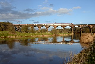
Dutton Viaduct is on the West Coast Main Line where it crosses the River Weaver and the Weaver Navigation between the villages of Dutton and Acton Bridge in Cheshire, England, not far from Dutton Horse Bridge. It is recorded in the National Heritage List for England as a Grade II* listed building.

Swanley is a hamlet at SJ618523 in the unitary authority of Cheshire East and the ceremonial county of Cheshire, England. It mainly falls within the civil parish of Burland, with a part in Baddiley. Swanley lies around 2+1⁄2 miles (4.0 km) to the west of Nantwich and immediately north of the hamlet of Stoneley Green. Nearby villages include Burland, Acton and Ravensmoor. A dry moated site is located near the 16th-century Swanley Hall, and there are two 17th-century buildings. The Llangollen Canal runs through the hamlet, with two locks, two bridges and a marina.
Acton Bridge is a civil parish in Cheshire West and Chester, England. It is mainly rural and contains the village of Acton Bridge. The parish is traversed by the River Weaver and Weaver Navigation in an east–west direction, the West Coast Main Line in a north–south direction, and the A49 road runs from northwest to southeast. It contains nine buildings that are recorded in the National Heritage List for England as designated listed buildings. Two of these are listed at Grade II*, and the other seven at Grade II. Most of the buildings are houses or farm buildings, but the list also includes a railway viaduct, a lock on the Weaver Navigation, and a guidepost.
Dutton is a civil parish in Cheshire West and Chester, England. It contains the village of Dutton, but is otherwise rural. Important transport links pass through the parish. The West Coast Main Line runs through in a north–south direction. Dutton Viaduct and the Weaver Junction are in the parish. The Trent and Mersey Canal runs through it in a northwest–southeast direction, and enters the south portal of the Preston Brook Tunnel. The A533 road traverses the parish in a similar direction. In the southern part of the parish, running east–west, is the River Weaver and the Weaver Navigation. Included in the parish are 22 buildings that are recorded in the National Heritage List for England as designated listed buildings. Some of the buildings are houses, and others are associated with the Trent and Mersey Canal and the Weaver Navigation.
Northwich is a civil parish and a town in Cheshire West and Chester, England. It contains 35 buildings that are recorded in the National Heritage List for England as designated listed buildings. Two of these are listed at Grade I, the highest grade, and the rest at the lowest grade, Grade II; none are listed at the middle grade, Grade II*. The River Dane joins the River Weaver and the Weaver Navigation within the parish. Also passing through the parish are the A533 road, the Trent and Mersey Canal, and a railway built by the Cheshire Lines Committee. Many of the listed buildings are associated with these features.
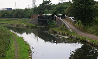
The Acton swing bridge is a swing bridge spanning the River Weaver in the village of Acton Bridge in north Cheshire, England. First operated in 1933, it carries the A49 trunk road.

Dutton Locks is a historic lock on the River Weaver in Cheshire, England. The locks are Grade II listed with Historic England. The locks are still in use and form a destination for walkers and cyclists. Dutton Locks is also the name of a hamlet of approximately six residences adjacent to the locks.


