Duty (village)

Last updated

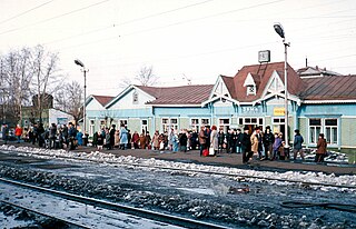
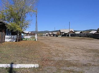
Duty (Russian : Ду́тый, also known as "Дуты" or "Дутово") is a village ( selo ) in the southern part of Khiloksky District of Zabaykalsky Krai, Russia, located at the confluence of the Duty and Arey Rivers, 65 kilometers (40 mi) away from Khilok.

Russian language East Slavic language

Russian is an East Slavic language, which is official in the Russian Federation, Belarus, Kazakhstan and Kyrgyzstan, as well as being widely used throughout Eastern Europe, the Baltic states, the Caucasus and Central Asia. It was the de facto language of the Soviet Union until its dissolution on 25 December 1991. Although, nowadays, nearly three decades after the breakup of the Soviet Union, Russian is used in official capacity or in public life in all the post-Soviet nation-states, as well as in Israel and Mongolia, the rise of state-specific varieties of this language tends to be strongly denied in Russia, in line with the Russian World ideology.

The classification system of the types of inhabited localities in Russia, the former Soviet Union, and some other post-Soviet states has certain peculiarities compared with the classification systems in other countries.

Khiloksky District District in Zabaykalsky Krai, Russia

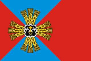
Khiloksky District is an administrative and municipal district (raion), one of the thirty-one in Zabaykalsky Krai, Russia. It is located in the southwest of the krai, and borders with Ulyotovsky District in the east, Krasnochikoysky District in the south, and with Petrovsk-Zabaykalsky District in the west. The area of the district is 14,800 square kilometers (5,700 sq mi). Its administrative center is the town of Khilok. Population: 31,760 (2010 Census); 33,434 ; 40,758 (1989 Census). The population of Khilok accounts for 36.3% of the district's total population.

In the 1950s, a logging post of Areysky Logging-Lumbering Enterprise was located here. During the 1970s and 1980s, Duty was home to a Soviet Army engineering battalion building the road between Ulan-Ude and Chita. Duty was abandoned in 2002 because of the devastating wildfire,[ citation needed ] but, as of 2004, it was not officially abolished. [1]

Soviet Army name given to the main part of the Armed Forces of the Soviet Union between 1946 and 1992

The Soviet Army is the name given to the main land-based branch of the Soviet Armed Forces between February 1946 and December 1991, when it was replaced with the Russian Ground Forces, although it was not fully abolished until 25 December 1993. Until 25 February 1946, it was known as the Red Army, established by decree on 15 (28) January 1918 "to protect the population, territorial integrity and civil liberties in the territory of the Soviet state." The Strategic Missile Troops, Air Defense Forces and Air Forces were part of the Soviet Army in addition to the Ground Forces.

Ulan-Ude City in Buryatia, Russia

Ulan-Ude is the capital city of the Republic of Buryatia, Russia; it is located about 100 kilometers (62 mi) southeast of Lake Baikal on the Uda River at its confluence with the Selenga. According to the 2010 Census, 404,426 people lived in Ulan-Ude; up from 359,391 recorded in the 2002 Census, making the city the third largest in the Russian Far East by population.

Chita, Zabaykalsky Krai City in Zabaykalsky Krai, Russia

Chita is a city and the administrative center of Zabaykalsky Krai, Russia, located at the confluence of the Chita and Ingoda Rivers and on the Trans-Siberian Railway, 900 kilometers (560 mi) east of Irkutsk. Population: 324,444 (2010 Census); 316,643 (2002 Census); 365,754 (1989 Census).

The archeological complex of Shaman-Gora is located in the vicinity of the village.

Shaman-Gora

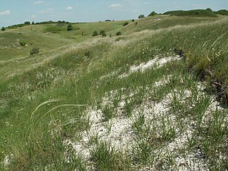
Shaman-Gora is an archeological site on the outskirts of the village of Duty in Khiloksky District of Zabaykalsky Krai. It is famous for its about 100 petroglyphs dating from 4000–1000 BCE. It is thought to be a ritual site for the local tribes. There are two main strata and their artifacts show that there was a highly developed society in the region at the confluence of the Duty River and Arey Rivers.

Related Research Articles

Chita Oblast oblast of Russia

Chita Oblast was a federal subject of Russia in southeast Siberia, Russia. Its administrative center was the city of Chita. It had extensive international borders with China (998 km) and Mongolia (868 km) and internal borders with Irkutsk and Amur Oblasts, as well as with the republics of Buryatia and Yakutia. Its area was 431,500 square kilometers (166,600 sq mi). Population: 1,155,346 (2002 Census); 1,377,975 (1989 Census).

Agin-Buryat Okrug

Agin-Buryat Okrug, or Aga Buryatia, is an administrative division of Zabaykalsky Krai, Russia. It was a federal subject of Russia until it merged with Chita Oblast to form Zabaykalsky Krai on March 1, 2008. Prior to the merger, it was called Agin-Buryat Autonomous Okrug. Its administrative center is the urban-type settlement of Aginskoye.

Khimki City in Moscow Oblast, Russia

Khimki is a city in Moscow Oblast, Russia, 30 kilometres northwest of central Moscow.

Malakhovka, Moscow Oblast Work settlement in Moscow Oblast, Russia

Malakhovka, a Moscow suburb renowned for its historic dachas, is an urban locality in Lyuberetsky District of Moscow Oblast, Russia. Population: 24,004 (2010 Census); 18,552 (2002 Census); 26,454 (1989 Census).

Zima (town) Town in Irkutsk Oblast, Russia

Zima is a town in Irkutsk Oblast, Russia, located at the point where the Trans-Siberian Railway crosses the Oka River. Population: 32,508 (2010 Census); 34,899 (2002 Census); 41,814 (1989 Census).

Lytkarino Town in Moscow Oblast, Russia

Lytkarino is a town in Moscow Oblast, Russia, located on the left bank of the Moskva River 6 kilometers (3.7 mi) southeast of Moscow(from MKAD). Population: 55,237 (2010 Census); 50,798 (2002 Census); 50,968 (1989 Census).

Zabaykalsky Krai First-level administrative division of Russia

Zabaykalsky Krai is a federal subject of Russia that was created on March 1, 2008 as a result of a merger of Chita Oblast and Agin-Buryat Autonomous Okrug, after a referendum held on the issue on March 11, 2007. Formerly part of the Siberian Federal District, the Krai is now part of the Russian Far East as of November 2018 in accordance with a decree issued by Russian President Vladimir Putin. The administrative center of the krai is located in the city of Chita. As of the 2010 Census, the population was 1,107,107.

Yedineniye can refer to:

Prokopyevsky District District in Kemerovo Oblast, Russia

Prokopyevsky District is an administrative district (raion), one of the nineteen in Kemerovo Oblast, Russia. As a municipal division, it is incorporated as Prokopyevsky Municipal District. It is located in the center of the oblast. The area of the district is 3,450 square kilometers (1,330 sq mi). Its administrative center is the city of Prokopyevsk. Population: 31,442 (2010 Census); 33,705 ; 35,657 (1989 Census).

Promyshlennovsky District District in Kemerovo Oblast, Russia

Promyshlennovsky District is an administrative district (raion), one of the nineteen in Kemerovo Oblast, Russia. As a municipal division, it is incorporated as Promyshlennovsky Municipal District. It is located in the west of the oblast. The area of the district is 3,083 square kilometers (1,190 sq mi). Its administrative center is the urban locality of Promyshlennaya. Population: 50,106 (2010 Census); 50,125 ; 47,150 (1989 Census). The population of Promyshlennaya accounts for 36.0% of the district's total population.

Yaysky District District in Kemerovo Oblast, Russia

Yaysky District is an administrative district (raion), one of the nineteen in Kemerovo Oblast, Russia. As a municipal division, it is incorporated as Yaysky Municipal District. It is located in the north of the oblast. The area of the district is 2,669 square kilometers (1,031 sq mi). Its administrative center is the urban locality of Yaya. Population: 20,383 (2010 Census); 24,982 ; 26,759 (1989 Census). The population of Yaya accounts for 57.3% of the district's total population.

Makaryevsky District District in Kostroma Oblast, Russia

Makaryevsky District is an administrative and municipal district (raion), one of the twenty-four in Kostroma Oblast, Russia. It is located in the south of the oblast. The area of the district is 4,850 square kilometers (1,870 sq mi). Its administrative center is the town of Makaryev. Population: 15,968 (2010 Census); 19,523 ; 24,900 (1989 Census). The population of Makaryev accounts for 45.6% of the district's total population.

Gorshechensky District District in Kursk Oblast, Russia

Gorshechensky District is an administrative and municipal district (raion), one of the twenty-eight in Kursk Oblast, Russia. It is located in the east of the oblast. The area of the district is 1,400 square kilometers (540 sq mi). Its administrative center is the urban locality of Gorshechnoye. Population: 18,591 (2010 Census); 22,835 ; 26,372 (1989 Census). The population of Gorshechnoye accounts for 33.0% of the district's total population.

Kastorensky District is an administrative and municipal district (raion), one of the twenty-eight in Kursk Oblast, Russia. It is located in the east of the oblast. The area of the district is 1,225 square kilometers (473 sq mi). Its administrative center is the urban locality of Kastornoye. Population: 18,195 (2010 Census); 24,237 ; 29,127 (1989 Census). The population of Kastornoye accounts for 21.1% of the district's total population.

Khomutovsky District District in Kursk Oblast, Russia

Khomutovsky District is an administrative and municipal district (raion), one of the twenty-eight in Kursk Oblast, Russia. It is located in the west of the oblast. The area of the district is 1,194 square kilometers (461 sq mi). Its administrative center is the urban locality of Khomutovka. Population: 11,429 (2010 Census); 16,432 ; 21,110 (1989 Census). The population of Khomutovka accounts for 37.0% of the district's total population.

Sukholozhsky District is an administrative district (raion), one of the thirty in Sverdlovsk Oblast, Russia. As a municipal division, it is incorporated as Sukhoy Log Urban Okrug. Its administrative center is the town of Sukhoy Log. Population : 14,451 ; 13,901 (2002 Census); 14,049 (1989 Census).

Shchyokinsky District District in Tula Oblast, Russia

Shchyokinsky District is an administrative district (raion), one of the twenty-three in Tula Oblast, Russia. Within the framework of municipal divisions, it is incorporated as Shchyokinsky Municipal District. It is located in the center of the oblast. The area of the district is 1,393.4 square kilometers (538.0 sq mi). Its administrative center is the town of Shchyokino. Population: 106,595 ; 43,064 (2002 Census); 48,434 (1989 Census). The population of the administrative center accounts for 54.5% of the district's total population.

Budogoshch Urban-type settlement in Leningrad Oblast, Russia

Budogoshch is an urban locality in Kirishsky District of Leningrad Oblast, Russia, located on the banks of the Pchyovzha River. Municipally, it serves as the administrative center of Budogoshskoye Urban Settlement, one of the two urban settlements in the district. Population: 3,871 (2010 Census); 3,885 (2002 Census); 4,673 (1989 Census).

Urazovo is an urban-type settlement in Valuysky District of Belgorod Oblast, Russia. Population: 6,982 (2010 Census); 6,878 (2002 Census); 6,345 (1989 Census).

Pyatnitskoye is an urban-type settlement in Volokonovsky District of Belgorod Oblast, Russia. Population: 4,536 (2010 Census); 4,793 (2002 Census); 4,528 (1989 Census).

References

  1. Закон Читинской области №552-ЗЧО от 19 мая 2004 г. "Об установлении границ, наименований вновь образованных муниципальных образований и наделении их статусом сельского, городского поселения в Читинской области". Статья 1, 24-з (Law of Chita Oblast #552-ZChO of May 19, 2004 On Establishing the Borders, Names of Newly Formed Municipal Formations and On Granting Them the Status of Rural, Urban Settlement of Chita Oblast. Article 1, #24-z)

Coordinates: 50°59′31″N110°47′11″E / 50.99194°N 110.78639°E / 50.99194; 110.78639

Geographic coordinate system Coordinate system

A geographic coordinate system is a coordinate system that enables every location on Earth to be specified by a set of numbers, letters or symbols. The coordinates are often chosen such that one of the numbers represents a vertical position and two or three of the numbers represent a horizontal position; alternatively, a geographic position may be expressed in a combined three-dimensional Cartesian vector. A common choice of coordinates is latitude, longitude and elevation. To specify a location on a plane requires a map projection.