Africa is a continent comprising 63 political territories, representing the largest of the great southward projections from the main mass of Earth's surface. Within its regular outline, it comprises an area of 30,368,609 km2 (11,725,385 sq mi), excluding adjacent islands. Its highest mountain is Kilimanjaro; its largest lake is Lake Victoria.

Tanzania comprises many lakes, national parks, and Africa's highest point, Mount Kilimanjaro. Northeast Tanzania is mountainous, while the central area is part of a large plateau covered in grasslands. The country also contains the southern portion of Lake Victoria on its northern border with Uganda and Kenya.

Malawi is a landlocked country in southeast Africa. It is wholly within the tropics; from about 9°30S at its northernmost point to about 17°S at the southernmost tip. The country occupies a thin strip of land between Zambia and Mozambique, extending southwards into Mozambique along the valley of the Shire River. In the north and north east it also shares a border with Tanzania. Malawi is connected by rail to the Mozambican ports of Nacala and Beira. It lies between latitudes 9° and 18°S, and longitudes 32° and 36°E.

The Zambezi is the fourth-longest river in Africa, the longest east-flowing river in Africa and the largest flowing into the Indian Ocean from Africa. Its drainage basin covers 1,390,000 km2 (540,000 sq mi), slightly less than half of the Nile's. The 2,574 km (1,599 mi) river rises in Zambia and flows through eastern Angola, along the north-eastern border of Namibia and the northern border of Botswana, then along the border between Zambia and Zimbabwe to Mozambique, where it crosses the country to empty into the Indian Ocean.

The Central Region of Malawi, population 7,523,340 (2018), covers an area of 35,592 km². Its capital city is Lilongwe, which is also the national capital. The region has an outlet on Lake Malawi and borders neighbouring countries Zambia and Mozambique. The Chewa people make up the majority of the population today.

The Luangwa River is one of the major tributaries of the Zambezi River, and one of the four biggest rivers of Zambia. The river generally floods in the rainy season and then falls considerably in the dry season. It is one of the biggest unaltered rivers in Southern Africa and the 52,000 square kilometres (20,000 sq mi) that make up the surrounding valley are home to abundant wildlife.
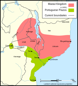
Maravi was a kingdom which straddled the current borders of Malawi, Mozambique, and Zambia, in the 16th century. The present-day name "Maláŵi" is said to derive from the Chewa word malaŵí, which means "flames". "Maravi" is a general name of the peoples of Malawi, eastern Zambia, and northeastern Mozambique. The Chewa language, which is also referred to as Nyanja, Chinyanja or Chichewa, and is spoken in southern and central Malawi, in Zambia and to some extent in Mozambique, is the main language that emerged from this empire.

Ruvuma River, formerly also known as the Rovuma River, is a river in the African Great Lakes region. During the greater part of its course, it forms the border between Tanzania and Mozambique. The river is 998 km (620 mi) long, with a drainage basin of ~155,000 km2 (60,000 sq mi) in size. Its mean annual discharge is 475 m3/s (16,800 cu ft/s) to 2,286 m3/s (80,700 cu ft/s) at its mouth.

Woronora Heights is a suburb in southern Sydney, in the state of New South Wales, Australia. Woronora Heights is located 29 kilometres south of the Sydney central business district, in the local government area of the Sutherland Shire. Woronora is a separate suburb, to the north. Most streets in Woronora Heights are named after birds.
Dedza is a district in the Central Region of Malawi. It covers an area of 3,624 km.² to the south of the Malawi capital, Lilongwe, between Mozambique and Lake Malawi. The capital is Dedza.
The Viphya Mountains, also known as the Viphya Plateau or Viphya Highlands, are a mountain range in Malawi's Northern Region.
The Kipengere Range, also known as the Livingstone Mountains, lies entirely in Njombe Region in southwest Tanzania at the northern end of Lake Nyasa. Near Lake Nyasa they are known as the Kinga Mountains. It is a plateau-like ridge of mountains running southeastwards from the basin of the Great Ruaha River in the north to that of the Ruhuhu River in the south, and forms part of the eastern escarpment of the East African Rift. The range is mostly clad in montane grasslands, renowned for their botanical diversity and displays of flowers, with montane evergreen forests mostly in stream valleys.

Kasungu National Park is a national park in Malawi. It is located west of Kasungu, about 175 km north of Lilongwe, extending along the Zambian border.

The wildlife of Malawi is composed of the flora and fauna of the country. Malawi is a landlocked country in southeastern Africa, with Lake Malawi taking up about a third of the country's area. It has around 187 species of mammal, some 648 species of birds have been recorded in the country and around 500 species of fish, many of them endemic, are found in its lakes and rivers. About 20% of the country has been set aside as national parks and game and forest reserves.

The Grose River, a perennial river that is part of the Hawkesbury-Nepean catchment, is located in the Blue Mountains region of New South Wales, Australia.

The South Rukuru River is a river of northern Malawi.

The Adams River is a tributary to the Thompson and Fraser Rivers in British Columbia, Canada. Beginning in the Monashee Mountains to the north, the Upper Adams River flows mainly southward and eventually reaches Adams Lake. The Lower Adams River begins at the southern end of the lake and flows into the extreme western end of Shuswap Lake. The river is one of the most important sockeye salmon breeding areas in North America. The run occurs in mid-October and can bring millions of fish to a concentrated area near the river mouth. Excavations of Secwepemc villages on the river have shown a long tradition of habitation and salmon fishing in the area. The river also served as an important transportation route for early logging operations in the watershed.

Lilongwe River is a river in Malawi; it flows through Lilongwe, the capital of the country.
The Southern Highlands is a highland region in southwestern Tanzania, at the northern end of Lake Malawi. The highlands include portions of Mbeya, Njombe, Rukwa, Ruvuma, and Songwe regions, bordering Malawi, Mozambique, and Zambia. Mbeya is the largest city in the highlands.

The Ruhuhu River is a river in Ruvuma Region, Tanzania.
