
Zambia is a landlocked country located in Southern Africa, to the east of Angola. It has a total area of 752,618 square kilometres, of which 9 220 km2 is water.

Malawi is a landlocked country in southeast Africa. It is wholly within the tropics; from about 9°30S at its northernmost point to about 17°S at the southernmost tip. The country occupies a thin strip of land between Zambia and Mozambique, extending southwards into Mozambique along the valley of the Shire River. In the north and north east it also shares a border with Tanzania. Malawi is connected by rail to the Mozambican ports of Nacala and Beira. It lies between latitudes 9° and 18°S, and longitudes 32° and 36°E.

The Zambezi is the fourth-longest river in Africa, the longest east-flowing river in Africa and the largest flowing into the Indian Ocean from Africa. Its drainage basin covers 1,390,000 km2 (540,000 sq mi), slightly less than half of the Nile's. The 2,574 km (1,599 mi) river rises in Zambia and flows through eastern Angola, along the north-eastern border of Namibia and the northern border of Botswana, then along the border between Zambia and Zimbabwe to Mozambique, where it crosses the country to empty into the Indian Ocean.

The Tumbuka is a Bantu ethnic group found in Malawi, Zambia and Tanzania. Tumbuka is classified as a part of the Bantu language family, and with origins in a geographic region between the Dwangwa River to the south, the North Rukuru River to the north, Lake Malawi to the east, and the Luangwa River. They are found in the valleys near the rivers, lake as well as the highlands of Nyika Plateau, where they are frequently referred to as Henga although this is strictly speaking the name of a subdivision.

Mzuzu is the capital of Malawi's Northern Region and is the third largest city by population in Malawi. The city has 221,272 residents and 20,000 commuters with about 1.7 million people in its metropolitan area. It is situated in Mzimba District. Mzuzu lies in a gap in the Viphya Mountains, and the agricultural region surrounding the city specializes in tea, rubber and coffee cultivation. The Viphya Plantation south of the city is the largest man-made forest in Africa, and the Lunyangwa and Kaning'ina forest preserves are east of the city. The town is located inside Mzimba District.
Mzimba is a town in the Mzimba District of Malawi. The district is inhabited by descendants of Tumbuka and few Ngoni people.

Rumphi is the capital of the Rumphi District in the Northern Region of Malawi. It is a lively town with a market which serves the widespread farming community. Rumphi is noted for the kindness of the people. It is directly on the way to Nyika National Park Nyika Plateau and Vwaza Marsh Game Reserve. Unlike its larger neighbour, Mzuzu, which has mild sunny weather almost all year, Rumphi has a differing climate. The town, being surrounded by hills, always has a nice wind. The town is bounded by the Rumphi river in the east and the South Rukuru River in the south.

The Northern Region is a region of Malawi. It had a population of 2,289,780 in 2018, and covers an area of 26,931 km2, making it the smallest region both by population and area. Its capital city is Mzuzu. Starting in the north and going clockwise, the Northern Region borders on Tanzania, Lake Malawi, Malawi's Central Region, and Zambia.
Mzimba is a district in the Northern Region of Malawi. The capital is Mzimba. The district covers an area of 10,473 km2 and has a population of 940,184. It is the largest district in Malawi.
Nkhata Bay is a district in the Northern Region of Malawi. The capital is Nkhata Bay. The district covers an area of 4,071 km.² and has a population of 164,761.
Rumphi is a district in the Northern Region of Malawi. The capital is Rumphi. The district covers an area of 4,769 km.² and has a population of 128,360.
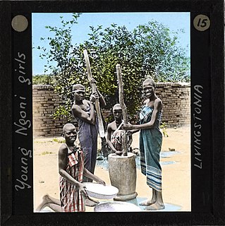
The Ngoni people are an ethnic group living in the present-day Southern African countries of Malawi, Mozambique, Tanzania, Zimbabwe, and Zambia. The Ngoni trace their origins to the Nguni and Zulu people of kwaZulu-Natal in South Africa. The displacement of the Ngoni people in the great scattering following the Zulu wars had repercussions in social reorganization as far north as Malawi and Zambia.

The Great East Road is a major road in Zambia and the main route linking its Eastern Province with the rest of the country. It is also the major link between Zambia and Malawi and between Zambia and northern Mozambique. However, the route does not carry as much traffic as many of the other regional arterial roads and between the main cities it serves, Lusaka and Chipata, it passes through rural and wilderness areas. In Lusaka the road forms the main arterial road for the eastern suburbs. The entire route from Lusaka to Chipata and the border with Malawi is designated the T4 road on Zambia's road network.
The Viphya Mountains, also known as the Viphya Plateau or Viphya Highlands, are a mountain range in located in Chikangawa in Malawi's Northern Region.

Eastern Province is one of Zambia's ten provinces. The province lies between the Luangwa River and borders with Malawi to the east and Mozambique to the south, from Isoka in the northeast to the north of Luangwa in the south. The provincial capital is Chipata. Eastern province has an area of 51,476 km2 (19,875 sq mi), locally shares border with three other provinces of the country and is divided into fifteen districts.

Vwaza Marsh Game Reserve is a national game reserve in Malawi.

Ikelenge District is a district of North-Western Province, Zambia. It was separated from Mwinilunga District in 2011.
Zwangendaba Gwaza kaZiguda Jele Gumbi, commonly known as Zwangendaba (1785–1848) was the first king of the Ngoni and Tumbuka people of Malawi, Zambia and Tanzania of the Jere Ngoni Clan from 1815 to 1857. He passed away in July 1848 and his son, Gwaza Jele, inherited his position soon after his death. He was the older brother of Somkhanda kaZiguda Jele who was also known as Gumbi and founded the Gumbi clan in Kwazulu-Natal in areas of Pongola.

The Chikangawa Forest Reserve, also known as the Viphya Plantation, is a man-made forest in the South Viphya Forest Reserve in Chikangawa, Malawi. It was established in 1948 and covers 1147.8 square kilometers. The forest is mainly composed of exotic pine trees. It is home to the Viphya Plantation, which was established in 1964 in a failed attempt to grow construction timber. The forest reserve is home to several native evergreen montane forests. The reserve was established to conserve the natural forests of the Viphya Mountains in Malawi. The forest provides a habitat for various plant and animal species, and supports sustainable forest management practices.
