
The geography of Canada describes the geographic features of Canada, the world's second largest country in total area.

Whitehorse is the capital and only city of Yukon, and the largest city in northern Canada. It was incorporated in 1950 and is located at kilometre 1426 on the Alaska Highway in southern Yukon. Whitehorse's downtown and Riverdale areas occupy both shores of the Yukon River, which originates in British Columbia and meets the Bering Sea in Alaska. The city was named after the White Horse Rapids for their resemblance to the mane of a white horse, near Miles Canyon, before the river was dammed.
Tutchone is a Athabaskan language spoken by the Northern and Southern Tutchone First Nations in central and southern regions of Yukon Territory, Canada. Tutchone belongs to the Northern Athabaskan linguistic subfamily and has two primary varieties, Southern and Northern. Although they are sometimes considered separate languages, Northern and Southern Tutchone speakers are generally able to understand each other in conversation, albeit with moderate difficulty.
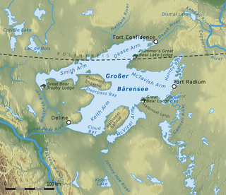
The Great Bear Lake is the largest lake entirely in Canada, the fourth-largest in North America, and the eighth-largest in the world. The lake is in the Northwest Territories, on the Arctic Circle between 65 and 67 degrees of northern latitude and between 118 and 123 degrees western longitude, 156 m (512 ft) above sea level.

The flag of Yukon, is a green, white, and blue tricolour with the coat of arms of Yukon at the centre above a wreath of fireweed, the territorial flower. An official flag for Yukon was created during the 1960s, a decade in which the national flag of Canada was chosen as well as several other provincial flags were created. The flag of Yukon was officially selected from a territory-wide design competition in 1967, with the winning design adopted on March 1, 1968.

The English River is a river in Kenora District and Thunder Bay District in Northwestern Ontario, Canada. It flows through Lac Seul to join the Winnipeg River as a right tributary. The river is in the Hudson Bay drainage basin, is 615 kilometres (382 mi) long and has a drainage basin of 52,300 square kilometres (20,200 sq mi). There are several hydroelectric plants on this river.

Carmacks is a village in Yukon on the Yukon River along the Klondike Highway, and at the west end of the Robert Campbell Highway from Watson Lake. The population is 493. It is the home of the Little Salmon/Carmacks First Nation, a Northern Tutchone-speaking people.

Mount Saskatchewan is a mountain located in the North Saskatchewan River valley of Banff National Park, in the Canadian Rockies of Alberta, Canada.

English River is an unincorporated place on the border of geographic Corman Township, Kenora District and the Unorganized Part of Thunder Bay District in Northwestern Ontario, Canada. It was a Hudson's Bay Company trading post between 1894 and 1911, and is located where Ontario Highway 17 crosses the English River at its confluence with the Scotch River.
The Little Salmon/Carmacks First Nation is a First Nation in the central Yukon Territory in Canada. Its original population centre was Little Salmon, Yukon, but most of its citizens live in Carmacks, Yukon. The language originally spoken by the Little Salmon/Carmacks First Nation people was Northern Tutchone. They call themselves Tagé Cho Hudän.

The Peel River is a tributary of the Mackenzie River in the Yukon and Northwest Territories in Canada. Its source is in the Ogilvie Mountains in the central Yukon at the confluence of the Ogilvie River and Blackstone River. Its main tributaries are:
The history of post-colonial Canada began on July 1, 1867, when the British colonies of Canada, New Brunswick, and Nova Scotia were united to form a single Dominion within the British Empire. Upon Confederation, the United Province of Canada was immediately split into the provinces of Ontario and Quebec. The colonies of Prince Edward Island and British Columbia joined shortly after, and Canada acquired the vast expanse of the continent controlled by the Hudson's Bay Company, which was eventually divided into new territories and provinces. Canada evolved into a fully sovereign state by 1982.

Heart Peaks, originally known as the Heart Mountains, is a mountain massif in the Northern Interior of British Columbia, Canada. It is 90 km (56 mi) northwest of the small community of Telegraph Creek and just southwest of Callison Ranch. With a maximum elevation of 2,012 m (6,601 ft), it rises above the surrounding landscape on the Nahlin Plateau, which is part of the western Stikine Plateau. Heart Peaks has been an area of prospecting since the 1980s with the discovery of precious metals.

The Indian River is a river in Yukon, Canada. It is in the Bering Sea drainage basin and is a right tributary of the Yukon River.

Lake George is a lake in Chippewa County, Michigan, United States, and Algoma District, Northwestern Ontario, Canada, that lies between Sugar Island in Michigan on the west and the Ontario mainland on the east.
Dan Curtis is a Canadian politician, who was elected mayor of Whitehorse, Yukon in the 2012 municipal election.

