The Arctic Archipelago, also known as the Canadian Arctic Archipelago, is a group of islands north of the Canadian mainland.

Segrià is a comarca (county) in the west of Catalonia, Spain, bordering Aragon. As of 2001, over two thirds of its population live in the capital city of Lleida, which is also Catalonia's largest municipality, and remains the most populated comarca in the Lleida province. It takes its name from the river Segre.

The Queen Elizabeth Range is a rugged mountain range of the Transantarctic Mountains System, located in the Ross Dependency region of Antarctica.
Lima Kedai is an area in Iskandar Puteri, Johor Bahru District, Johor, Malaysia. It is located between Skudai and Gelang Patah. Lima Kedai is an important transit town for travelers on the Second Link Expressway.
Opodepe is the municipal seat of Opodepe Municipality in the north of the Mexican state of Sonora.

Antsakoamanondro is a municipality in Madagascar. It belongs to the district of Ambanja, which is a part of Diana Region. According to 2001 census the population of Antsakoamanondro was 5,622.
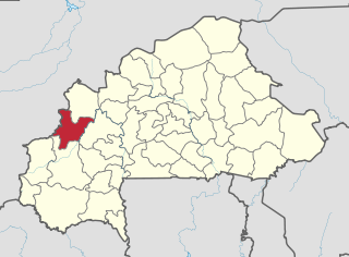
Douma is a town in the Tansila Department of Banwa Province in western Burkina Faso. As of 2005 it had a population of 1,154.
Cella is a town in the Tenkodogo Department of Boulgou Province in south-eastern Burkina Faso. As of 2005, the town has a population of 1,731.

Silnowo is a village in the administrative district of Gmina Borne Sulinowo, within Szczecinek County, West Pomeranian Voivodeship, in north-western Poland. It lies approximately 5 kilometres (3 mi) north-west of Borne Sulinowo, 17 km (11 mi) south-west of Szczecinek, and 129 km (80 mi) east of the regional capital Szczecin.
Ipupiara is a municipality in the state of Bahia in the North-East region of Brazil.
Maiquinique is a municipality in the state of Bahia in the North-East region of Brazil.
Itamari is a municipality in the state of Bahia in the North-East region of Brazil.

Pindaré-Mirim is a municipality in the state of Maranhão in the Northeast region of Brazil.
Pocrane is a municipality in the state of Minas Gerais in the Southeast region of Brazil.
Entre Folhas is a municipality in the state of Minas Gerais in the Southeast region of Brazil.
Ivatuba is a municipality in the state of Paraná in the Southern Region of Brazil.
Pato Bragado is a municipality in the state of Paraná in the Southern Region of Brazil.
Shedegali is a village in Belgaum district of Karnataka, India.

Campo de Cartagena is a natural region (comarca) located in the Region of Murcia, in Spain. For administrative purposes, it is also known, as Comarca del Campo de Cartagena or Comarca de Cartagena. It is located in the southeast of the Iberian Peninsula, forming a plain which extends from the Sierra de Carrascoy to the Mediterranean. The capital city is Cartagena, the most important Naval Base of the Spanish Navy in the Mediterranean Sea.
German submarine U-286 was a Type VIIC U-boat of Nazi Germany's Kriegsmarine during World War II.