Swiss German is any of the Alemannic dialects spoken in the German-speaking part of Switzerland and in some Alpine communities in Northern Italy bordering Switzerland. Occasionally, the Alemannic dialects spoken in other countries are grouped together with Swiss German as well, especially the dialects of Liechtenstein and Austrian Vorarlberg, which are closely associated to Switzerland's.

The canton of Valais is one of the 26 cantons of Switzerland, situated in the southwestern part of the country, around the valley of the Rhône from its headwaters to Lake Geneva, separating the Pennine Alps from the Bernese Alps. The canton is simultaneously one of the driest regions of Switzerland in its central Rhône valley and among the wettest, having large amounts of snow and rain up on the highest peaks found in Switzerland. The canton of Valais is widely known for the Matterhorn and resort towns such as Crans-Montana, Saas Fee, Verbier and Zermatt. It is composed of 13 districts and its capital is Sion.

The Bernese Mountain Dog is a large-sized breed of dog, one of the four breeds of Sennenhund-type dogs from the Swiss Alps. The name Sennenhund is derived from the German Senne and Hund (hound/dog), as they accompanied the alpine herders and dairymen called Senn. Berner refers to the area of the breed’s origin, in the canton of Bern. This mountain dog was originally kept as a general farm dog. Large Sennenhunde in the past were also used as draft animals, pulling carts. The breed was officially established in 1907. In 1937, the American Kennel Club recognized it; today, the club classifies it as a member of the Working Group.

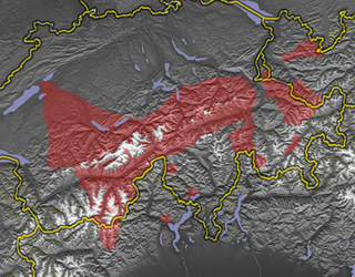
The canton of Bern or Berne is the second largest of the 26 Swiss cantons by both surface area and population. Located in west-central Switzerland, it borders the canton of Jura and the canton of Solothurn to the north. To the west lie the canton of Neuchâtel, the canton of Fribourg and canton of Vaud. To the south lies the canton of Valais. East of the canton of Bern lie the cantons of Uri, Nidwalden, Obwalden, Lucerne and Aargau.
The Walser are the speakers of the Walser German dialects, a variety of Highest Alemannic. They inhabit the Alps of Switzerland and Liechtenstein, as well as the fringes of Italy and Austria. The Walser people are named after the Wallis (Valais), the uppermost Rhône valley, where they settled from roughly the 10th century in the late phase of the migration of the Alamanni, crossing from the Bernese Oberland; because of linguistic differences among the Walser dialects, it is supposed that there were two independent immigration routes.

Romandy is the French-speaking part of western Switzerland. In 2018, about 2.1 million people, or 25.1% of the Swiss population, lived in Romandy. The bulk of the romand population lives in the Arc Lémanique region along Lake Geneva, connecting Geneva, Vaud and the Lower Valais.

The Berner Oberland, is the higher part of the canton of Bern, Switzerland, in the southern end of the canton, and one of the canton's five administrative regions.
This article is about the phonology of Bernese German. It deals with current phonology and phonetics, including geographical variants. Like other High Alemannic varieties, it has a two-way contrast in plosives and fricatives that is not based on voicing, but on length. The absence of voice in plosives and fricatives is typical for all High German varieties, but many of them have no two-way contrast due to general lenition.
Bernese Jura is the name for the French-speaking area of the Swiss canton of Bern, and from 2010 one of ten administrative divisions of the canton.

The Schreckhorn is a mountain in the Bernese Alps. It is the highest peak located entirely in the canton of Berne. The Schreckhorn is the northernmost Alpine four-thousander and the northernmost summit rising above 4,000 metres in Europe.

The Blüemlisalp is a massif of the Bernese Alps, in the territory of the municipalities of Kandersteg and Reichenbach im Kandertal.

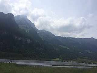
The Schynige Platte is a small mountain ridge and a viewpoint in the Bernese Highlands and belongs to the Schwarzhorn group. The mountain range consists of three peaks: Gumihorn, Tuba, and the closest summit next to the viewpoint, Geiss. The viewpoint lies at an altitude of about 2,000 metres (7,000 ft), at the western end of a prominent ridge of the Schwarzhorn group, which separates the valley of the Schwarze Lütschine from Lake Brienz.
The Chablais Alps are a mountain range in the western Alps. They are situated between Lake Geneva and the Mont Blanc Massif. The Col des Montets separates them from the Mont Blanc Massif in the south, and the Rhône valley separates them from the Bernese Alps in the east.

The Grand Muveran is a mountain of the Bernese Alps, located on the border between the cantons of Vaud and Valais. At 3,051 metres, it is the highest summit of the group lying between the Rhone knee and the Pas de Cheville and the westernmost three-thousander of the Bernese Alps. The closest localities are Les Plans-sur-Bex and Ovronnaz (Valais). It is accompanied by the smaller peak of Petit Muveran.

The Bärglistock is a mountain of the Bernese Alps, located east of Grindelwald in the Bernese Oberland. The mountain is the tripoint between the valleys of the Upper Grindelwald Glacier, the Unteraar Glacier and the Gauli Glacier.
The Ärmighorn is a mountain of the Bernese Alps, located east of Kandergrund in the Bernese Oberland. It lies north of the Dündenhorn, on the range between the Kandertal and the Kiental.
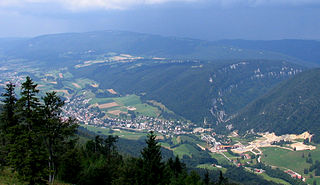
Blue cake is a flaky pastry that is a specialty of the Frutig valley in the Bernese Oberland, Switzerland. It consists only of puff pastry with no filling or other ingredients. Despite its name, it is not blue.

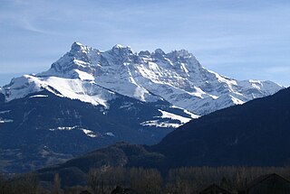
The Jungfrau-Aletsch protected area is located in south-western Switzerland between the cantons of Berne and Valais. It is a mountainous region in the easternmost side of the Bernese Alps, containing the northern wall of Jungfrau and Eiger, and the largest glaciated area in western Eurasia, comprising the Aletsch Glacier. The Jungfrau-Aletsch protected area is the first World Natural Heritage site in the Alps, it was inscribed in 2001.

Lucens Castle is a castle in the municipality of Lucens in the canton of Vaud in Switzerland. It is a Swiss heritage site of national significance.


