Ostrowsko is a village in Poland, in Lesser Poland Voivodeship, Nowy Targ County. In the years 1975-1998 it was in the Nowy Sącz Voivodeship. Ostrowsko is on the road from Nowy Targ to Czorsztyn and is located by the Dunajec River.

Kopaliny is a village in the administrative district of Gmina Nowy Wiśnicz, within Bochnia County, Lesser Poland Voivodeship, in southern Poland. It lies approximately 2 kilometres (1 mi) north of Nowy Wiśnicz, 6 km (4 mi) south of Bochnia, and 40 km (25 mi) east of the regional capital Kraków.
Krzyżówka is a village in the administrative district of Gmina Łabowa, within Nowy Sącz County, Lesser Poland Voivodeship, in southern Poland. It lies approximately 9 kilometres (6 mi) south-east of Łabowa, 25 km (16 mi) south-east of Nowy Sącz, and 97 km (60 mi) south-east of the regional capital Kraków.
Czarny Potok is a village in the administrative district of Gmina Łącko, within Nowy Sącz County, Lesser Poland Voivodeship, in southern Poland. It lies approximately 5 kilometres (3 mi) north-east of Łącko, 17 km (11 mi) west of Nowy Sącz, and 66 km (41 mi) south-east of the regional capital Kraków.
Maszkowice is a village in the administrative district of Gmina Łącko, within Nowy Sącz County, Lesser Poland Voivodeship, in southern Poland. It lies approximately 4 kilometres (2 mi) east of Łącko, 17 km (11 mi) west of Nowy Sącz, and 68 km (42 mi) south-east of the regional capital Kraków.

Leluchów is a village in the administrative district of Gmina Muszyna, within Nowy Sącz County, Lesser Poland Voivodeship, in southern Poland, close to the border with Slovakia. It lies approximately 7 kilometres (4 mi) south of Muszyna, 40 km (25 mi) south-east of Nowy Sącz, and 111 km (69 mi) south-east of the regional capital Kraków.
Ciche is a village in the administrative district of Gmina Czarny Dunajec, within Nowy Targ County, Lesser Poland Voivodeship, in southern Poland, close to the border with Slovakia. It lies approximately 16 kilometres (10 mi) south-west of Nowy Targ and 76 km (47 mi) south of the regional capital Kraków.
Dział is a village in the administrative district of Gmina Czarny Dunajec, within Nowy Targ County, Lesser Poland Voivodeship, in southern Poland, close to the border with Slovakia. It lies approximately 9 kilometres (6 mi) north-east of Czarny Dunajec, 9 km (6 mi) north-west of Nowy Targ, and 63 km (39 mi) south of the regional capital Kraków.
Wróblówka is a village in the administrative district of Gmina Czarny Dunajec, within Nowy Targ County, Lesser Poland Voivodeship, in southern Poland, close to the border with Slovakia. It lies approximately 10 kilometres (6 mi) west of Nowy Targ and 67 km (42 mi) south of the regional capital Kraków.
Mizerna is a village in the administrative district of Gmina Czorsztyn, within Nowy Targ County, Lesser Poland Voivodeship, in southern Poland, close to the border with Slovakia. It lies approximately 3 kilometres (2 mi) east of Maniowy, 21 km (13 mi) east of Nowy Targ, and 71 km (44 mi) south of the regional capital Kraków.

Harklowa is a village in the administrative district of Gmina Nowy Targ, within Nowy Targ County, Lesser Poland Voivodeship, in southern Poland. It lies approximately 11 kilometres (7 mi) east of Nowy Targ and 68 km (42 mi) south of the regional capital Kraków.

Klikuszowa is a village in the administrative district of Gmina Nowy Targ, within Nowy Targ County, Lesser Poland Voivodeship, in southern Poland. It lies approximately 7 kilometres (4 mi) north-west of Nowy Targ and 61 km (38 mi) south of the regional capital Kraków.
Krauszów is a village in the administrative district of Gmina Nowy Targ, within Nowy Targ County, Lesser Poland Voivodeship, in southern Poland. It lies approximately 5 kilometres (3 mi) north-west of Nowy Targ and 65 km (40 mi) south of the regional capital Kraków.

Lasek is a village in the administrative district of Gmina Nowy Targ, within Nowy Targ County, Lesser Poland Voivodeship, in southern Poland. It lies approximately 7 kilometres (4 mi) north-west of Nowy Targ and 61 km (38 mi) south of the regional capital Kraków.
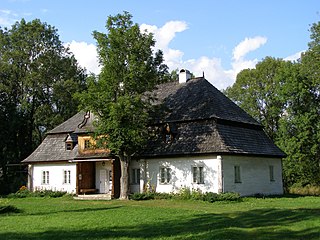
Łopuszna is a village in the administrative district of Gmina Nowy Targ, within Nowy Targ County, Lesser Poland Voivodeship, in southern Poland. It lies approximately 9 kilometres (6 mi) east of Nowy Targ and 66 km (41 mi) south of the regional capital Kraków. The village, with the population of about 1,300 lies on the Dunajec river, at the foot of the Gorce Mountains.
Morawczyna is a village in the administrative district of Gmina Nowy Targ, within Nowy Targ County, Lesser Poland Voivodeship, in southern Poland. It lies approximately 7 kilometres (4 mi) north-west of Nowy Targ and 63 km (39 mi) south of the regional capital Kraków.

Sieniawa is a village in the administrative district of Gmina Raba Wyżna, within Nowy Targ County, Lesser Poland Voivodeship, in southern Poland. It lies approximately 5 kilometres (3 mi) south-east of Raba Wyżna, 10 km (6 mi) north-west of Nowy Targ, and 59 km (37 mi) south of the regional capital Kraków.
Zaskale is a village in the administrative district of Gmina Szaflary, within Nowy Targ County, Lesser Poland Voivodeship, in southern Poland. It lies approximately 5 kilometres (3 mi) north-west of Szaflary, 4 km (2 mi) south-west of Nowy Targ, and 68 km (42 mi) south of the regional capital Kraków.
Miszewo Murowane is a village in the administrative district of Gmina Bodzanów, within Płock County, Masovian Voivodeship, in east-central Poland. It lies approximately 7 kilometres (4 mi) west of Bodzanów, 18 km (11 mi) south-east of Płock, and 79 km (49 mi) west of Warsaw.


