Ciche is a village in the administrative district of Gmina Czarny Dunajec, within Nowy Targ County, Lesser Poland Voivodeship, in southern Poland, close to the border with Slovakia. It lies approximately 16 kilometres (10 mi) south-west of Nowy Targ and 76 km (47 mi) south of the regional capital Kraków.
Czerwienne is a village in the administrative district of Gmina Czarny Dunajec, within Nowy Targ County, Lesser Poland Voivodeship, in southern Poland, close to the border with Slovakia. It lies approximately 13 kilometres (8 mi) south-west of Nowy Targ and 76 km (47 mi) south of the regional capital Kraków.
Dział is a village in the administrative district of Gmina Czarny Dunajec, within Nowy Targ County, Lesser Poland Voivodeship, in southern Poland, close to the border with Slovakia. It lies approximately 9 kilometres (6 mi) north-east of Czarny Dunajec, 9 km (6 mi) north-west of Nowy Targ, and 63 km (39 mi) south of the regional capital Kraków.

Koniówka is a village in the administrative district of Gmina Czarny Dunajec, within Nowy Targ County, Lesser Poland Voivodeship, in southern Poland, close to the border with Slovakia. It lies approximately 16 kilometres (10 mi) south-west of Nowy Targ and 74 km (46 mi) south of the regional capital Kraków.

Pieniążkowice is a village in the administrative district of Gmina Czarny Dunajec, within Nowy Targ County, Lesser Poland Voivodeship, in southern Poland, close to the border with Slovakia. It lies approximately 11 kilometres (7 mi) north-west of Nowy Targ and 61 km (38 mi) south of the regional capital Kraków.
Wróblówka is a village in the administrative district of Gmina Czarny Dunajec, within Nowy Targ County, Lesser Poland Voivodeship, in southern Poland, close to the border with Slovakia. It lies approximately 10 kilometres (6 mi) west of Nowy Targ and 67 km (42 mi) south of the regional capital Kraków.

Chyżne, is a village in the administrative district of Gmina Jabłonka, within Nowy Targ County, Lesser Poland Voivodeship, in southern Poland, close to the border with Slovakia. It lies approximately 6 kilometres (4 mi) south of Jabłonka, 26 km (16 mi) west of Nowy Targ, and 73 km (45 mi) south of the regional capital Kraków. The village has a population of 1,200.

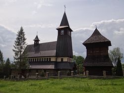
Dębno is a village in the administrative district of Gmina Nowy Targ, within Nowy Targ County, Lesser Poland Voivodeship, in southern Poland. It lies approximately 14 kilometres (9 mi) east of Nowy Targ and 69 km (43 mi) south of the regional capital Kraków.

Długopole is a village in the administrative district of Gmina Nowy Targ, within Nowy Targ County, Lesser Poland Voivodeship, in southern Poland. It lies approximately 7 kilometres (4 mi) west of Nowy Targ and 65 km (40 mi) south of the regional capital Kraków.
Gronków is a village in the administrative district of Gmina Nowy Targ, within Nowy Targ County, Lesser Poland Voivodeship, in southern Poland. It lies approximately 7 kilometres (4 mi) south-east of Nowy Targ and 71 km (44 mi) south of the regional capital Kraków.

Harklowa is a village in the administrative district of Gmina Nowy Targ, within Nowy Targ County, Lesser Poland Voivodeship, in southern Poland. It lies approximately 11 kilometres (7 mi) east of Nowy Targ and 68 km (42 mi) south of the regional capital Kraków.

Klikuszowa is a village in the administrative district of Gmina Nowy Targ, within Nowy Targ County, Lesser Poland Voivodeship, in southern Poland. It lies approximately 7 kilometres (4 mi) north-west of Nowy Targ and 61 km (38 mi) south of the regional capital Kraków.
Knurów is a village in the administrative district of Gmina Nowy Targ, within Nowy Targ County, Lesser Poland Voivodeship, in southern Poland. It lies approximately 13 kilometres (8 mi) east of Nowy Targ and 67 km (42 mi) south of the regional capital Kraków.
Krauszów is a village in the administrative district of Gmina Nowy Targ, within Nowy Targ County, Lesser Poland Voivodeship, in southern Poland. It lies approximately 5 kilometres (3 mi) north-west of Nowy Targ and 65 km (40 mi) south of the regional capital Kraków.

Lasek is a village in the administrative district of Gmina Nowy Targ, within Nowy Targ County, Lesser Poland Voivodeship, in southern Poland. It lies approximately 7 kilometres (4 mi) north-west of Nowy Targ and 61 km (38 mi) south of the regional capital Kraków.
Morawczyna is a village in the administrative district of Gmina Nowy Targ, within Nowy Targ County, Lesser Poland Voivodeship, in southern Poland. It lies approximately 7 kilometres (4 mi) north-west of Nowy Targ and 63 km (39 mi) south of the regional capital Kraków.
Trute is a village in the administrative district of Gmina Nowy Targ, within Nowy Targ County, Lesser Poland Voivodeship, in southern Poland.

Sieniawa is a village in the administrative district of Gmina Raba Wyżna, within Nowy Targ County, Lesser Poland Voivodeship, in southern Poland. It lies approximately 5 kilometres (3 mi) south-east of Raba Wyżna, 10 km (6 mi) north-west of Nowy Targ, and 59 km (37 mi) south of the regional capital Kraków.
Bańska Wyżna is a village in the administrative district of Gmina Szaflary, within Nowy Targ County, Lesser Poland Voivodeship, in southern Poland. It lies approximately 6 kilometres (4 mi) south-west of Szaflary, 8 km (5 mi) south of Nowy Targ, and 74 km (46 mi) south of the regional capital Kraków.