Waksmund

Last updated
Waksmund
Village

Waksmund from Gorce.jpg

Waksmund from Gorce
Poland adm location map.svg
Red pog.svg
Waksmund
Coordinates: 49°29′N20°5′E / 49.483°N 20.083°E / 49.483; 20.083
Country Flag of Poland.svg  Poland
Voivodeship Lesser Poland
County Nowy Targ
Gmina Gmina Nowy Targ
Highest elevation 670 m (2,200 ft)
Lowest elevation 545 m (1,788 ft)
Population 2,439

Waksmund [ˈvaksmunt] is a village in the administrative district of Gmina Nowy Targ, within Nowy Targ County, Lesser Poland Voivodeship, in southern Poland. It lies approximately 3 kilometres (2 mi) east of Nowy Targ and 80 km (50 mi) south of the regional capital Kraków. [1]

Village Small clustered human settlement smaller than a town

A village is a clustered human settlement or community, larger than a hamlet but smaller than a town, with a population ranging from a few hundred to a few thousand. Though villages are often located in rural areas, the term urban village is also applied to certain urban neighborhoods. Villages are normally permanent, with fixed dwellings; however, transient villages can occur. Further, the dwellings of a village are fairly close to one another, not scattered broadly over the landscape, as a dispersed settlement.

Gmina Nowy Targ is a rural gmina in Nowy Targ County, Lesser Poland Voivodeship, in southern Poland. Its seat is the town of Nowy Targ, although the town is not part of the territory of the gmina.

Nowy Targ County County in Lesser Poland, Poland

Nowy Targ County is a unit of territorial administration and local government (powiat) in Lesser Poland Voivodeship, southern Poland, on the Slovak border. It came into being on January 1, 1999, as a result of the Polish local government reforms passed in 1998. Its administrative seat and largest town is Nowy Targ, which lies 67 kilometres (42 mi) south of the regional capital Kraków. The county also contains the towns of Rabka-Zdrój, lying 18 km (11 mi) north of Nowy Targ, and Szczawnica, 35 km (22 mi) east of Nowy Targ.

Contents

The village has a population of 2,439.

History

The current village was settled by German immigrants under Magdeburg Law in the years 1334-1338. Previously, a village under the name Wilcze Pole or Wolf's Field existed. During the Battle of Grunwald in 1410 the village became famous for sending five armed men to fight on the side of King Władysław II Jagiełło for which the village received land in the nearby Tatra Mountains - Hala Waksmundzka (Meadow of Waksmund) and Dolina Waksmundzka (Valley of Waksmund) near Morskie Oko. During the Second World War, on June 29, 1943 the village was the site of one of the worst massacres carried out by the Nazi occupiers in the Podhale region, after the break-up of the Tatra Confederation revealed that many members of the resistance organization were from this village.

Battle of Grunwald battle of Teutonic Knights against Polish–Lithuanian union in 1410

The Battle of Grunwald, First Battle of Tannenberg or Battle of Žalgiris, was fought on 15 July 1410 during the Polish–Lithuanian–Teutonic War. The alliance of the Kingdom of Poland and the Grand Duchy of Lithuania, led respectively by King Władysław II Jagiełło (Jogaila) and Grand Duke Vytautas, decisively defeated the German–Prussian Teutonic Knights, led by Grand Master Ulrich von Jungingen. Most of the Teutonic Knights' leadership were killed or taken prisoner. Although defeated, the Teutonic Knights withstood the siege of their fortress in Marienburg (Malbork) and suffered minimal territorial losses at the Peace of Thorn (1411) (Toruń), with other territorial disputes continuing until the Peace of Melno in 1422. The knights, however, would never recover their former power, and the financial burden of war reparations caused internal conflicts and an economic downturn in the lands under their control. The battle shifted the balance of power in Central and Eastern Europe and marked the rise of the Polish–Lithuanian union as the dominant political and military force in the region.

Morskie Oko lake

Morskie Oko is the largest and fourth-deepest lake in the Tatra Mountains. It is located deep within the Tatra National Park, Poland, in the Rybi Potok Valley, of the High Tatras mountain range at the base of the Mięguszowiecki Summits, in Lesser Poland Voivodeship.

Podhale region of meadows

Podhale is Poland's southernmost region, sometimes referred to as the "Polish highlands". The Podhale is located in the foothills of the Tatra range of the Carpathian mountains.

Geography

Waksmund lies at an elevation of 565 metres primarily on the south bank of the river Dunajec in a hollow between two fossil sandar from the ice age. On the north bank of the Dunajec the land rises abruptly into the Gorce Mountains, on the south bank it slopes much gentler further south until it reaches the foothills of the Tatra Mountains some 6 to 8 kilometres further to the south near Białka Tatrzańska. The westernmost outlier of the Pieniny range, Gisowa Skała, lies a few kilometres to the southeast of the village near to Gronków. Within twenty kilometres of Waksmund, three national parks can be found: Gorczański, Tatrzański and Pieniński National Park.

Dunajec river

The Dunajec is a river running through northeastern Slovakia and southern Poland. It is a right tributary of the Vistula River. It begins in Nowy Targ at the junction of two short mountain rivers, Czarny Dunajec and Biały Dunajec. Dunajec forms the border between Poland and Slovakia for 17 kilometers in the Pieniny Środkowe range, east of the Czorsztyn reservoir.

Outwash plain Plain formed from glacier sediment that was transported by meltwater.

An outwash plain, also called a sandur, sandr or sandar, is a plain formed of glacial sediments deposited by meltwater outwash at the terminus of a glacier. As it flows, the glacier grinds the underlying rock surface and carries the debris along. The meltwater at the snout of the glacier deposits its load of sediment over the outwash plain, with larger boulders being deposited near the terminal moraine, and smaller particles travelling further before being deposited. Sandurs are common in Iceland where geothermal activity accelerates the melting of ice flows and the deposition of sediment by meltwater.

Gorce Mountains part of the Western Beskids mountain range spreading across southernmost Poland

The Gorce Mountains are part of the Western Beskids mountain range spreading across southernmost Poland. They are situated in Małopolska Province, at the western tip of the long Carpathian range extending east beyond the Dunajec River for some 1,500 kilometres (930 mi). The Gorce are characterized by numerous ridges reaching in all directions for up to 40 kilometres (25 mi) east–west with a series of higher elevations cut by deep river valleys.

Climate

On average, Waksmund has a fairly similar climate to other places in lower Podhale, although slightly colder - average annual temperature is around 5.6 °C, with the warmest month, July, averaging 16.5 °C, and the coldest month, January, averaging -6.2 °C, placing it firmly within the Dfb climate zone. Annual precipitation is around 850 millimetres, annual sunshine hours around 1500. Snow remains on the ground on average 111 days per year, and the average length of the growing season is 189 days. Spring sees large diurnal ranges - it can be up to 20 °C during mid day, while in the meanwhile at night it can still cool down to -10 °C. Winter temperatures however, are among the coldest in the whole of Poland due to the unique geography which causes the area to function quite like a cold sink; -35 °C is not unheard of on calm and clear nights above a fresh snow cover during a cold spell, and an unofficial all-time record low of -49 °C was reported in the winter of 1929. Whether this is valid or due to faulty equipment can never be known, fact is that Waksmund on such nights can be 5 to 7 °C colder than nearby Nowy Targ or Białka Tatrzańska. A similar effect, although far more pronounced, happens at Funtensee in Germany. The opposite has also known to happen, the area is especially susceptible to foehn winds, known locally as halny which can come from both the south as well as the north here, and rising air temperatures with as much as 15 °C in a matter of an hour, accompanied by low humidity and strong winds. Summers are mild, with average highs around 20 to 25 °C, and nighttime lows around 10 °C.

Funtensee lake in Germany

Funtensee is a lake in the Steinernes Meer plateau in the Nationalpark Berchtesgaden, Bavaria, Germany located on the larger of the two sinkholes of the uvala, known for record low temperatures up to 30 °C (54 °F) lower than the surrounding area. Its primary inflows are the Steingraben, Stuhlgraben and Rennergraben.

Germany Federal parliamentary republic in central-western Europe

Germany, officially the Federal Republic of Germany, is a country in Central and Western Europe, lying between the Baltic and North Seas to the north, and the Alps, Lake Constance and the High Rhine to the south. It borders Denmark to the north, Poland and the Czech Republic to the east, Austria and Switzerland to the south, France to the southwest, and Luxembourg, Belgium and the Netherlands to the west.

Notable residents

Józef Kuraś Lieutenant in the Polish Armed Forces

Józef Kuraś,, noms-de-guerre "Orzeł" (Eagle) and from June 1943 "Ogień" (Fire); was born in Waksmund near Nowy Targ. He served as lieutenant in the Polish Army during the invasion of Poland, and became the underground member of Armia Krajowa and Bataliony Chłopskie in the Podhale region. Soon after the end of World War II, he was one of the leaders of anticommunist resistance.

Andrzej Waksmundzki was a Polish chemist who became well known for his work in the field of chromatography.

Related Research Articles

Tatra Mountains mountain range in Europe

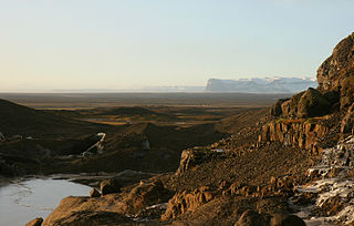
The Tatra Mountains, Tatras, or Tatra, is a mountain range that forms a natural border between Slovakia and Poland. This is the highest mountain range in the Carpathian Mountains. The Tatras should not be confused with the Low Tatras, which are located south of the Tatra Mountains in Slovakia.

Jurgów Place in Lesser Poland, Poland

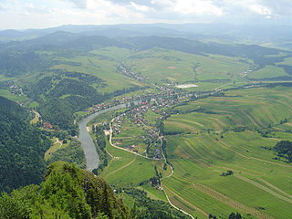
Jurgów is a small village in the Spisz region of southern Poland, near the border with Slovakia and the town of Bukowina Tatrzańska, on the Białka river. It lies approximately 2 kilometres (1 mi) east of Bukowina Tatrzańska, 15 km (9 mi) north-east of Zakopane, and 81 km (50 mi) south of the regional capital Kraków.

Zamagurie

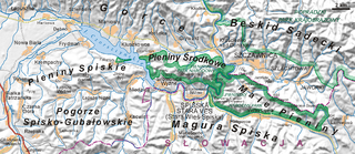
Zamagurie is an area in the north of the Spiš region, between the Spišská Magura in the south, the Dunajec river in the north and the Białka river in the west. It is divided between the Prešov Region of Slovakia and the Lesser Poland Voivodeship of Poland and is further divided between the Slovak districts of Stará Ľubovňa and Kežmarok and Polish gminas of Bukowina Tatrzańska, Nowy Targ and Łapsze Niżne. The centre of the region is the Slovak town Spišská Stará Ves, which is just near the border. The region also used to be one of the official tourist regions of Slovakia until 2004.

Kościelisko Village in Lesser Poland, Poland

Kościelisko is a village in Tatra County, Lesser Poland Voivodeship, in southern Poland, close to the border with Slovakia. It is the seat of the gmina called Gmina Kościelisko. It lies approximately 5 kilometres (3 mi) west of Zakopane and 86 km (53 mi) south of the regional capital Kraków.

Maniowy Place in Lesser Poland, Poland

Maniowy is a village in southern Poland situated in the Lesser Poland Voivodeship about 19 kilometres (12 mi) east of Nowy Targ and 71 km (44 mi) south of the regional capital Kraków. It has been the seat of the district of Gmina Czorsztyn since 1993.

Gmina Czarny Dunajec is a rural gmina in Nowy Targ County, Lesser Poland Voivodeship, in southern Poland, on the Slovak border. Its seat is the village of Czarny Dunajec, which lies approximately 13 kilometres (8 mi) west of Nowy Targ and 70 km (43 mi) south of the regional capital Kraków.

Gmina Szaflary is a rural gmina in Nowy Targ County, Lesser Poland Voivodeship, in southern Poland. Its seat is the village of Szaflary, which lies approximately 4 kilometres (2 mi) south of Nowy Targ and 71 km (44 mi) south of the regional capital Kraków.

Gmina Bukowina Tatrzańska Gmina in Lesser Poland, Poland

Gmina Bukowina Tatrzańska is a rural gmina in Tatra County, Lesser Poland Voivodeship, in southern Poland, on the Slovak border. Its seat is the village of Bukowina Tatrzańska, which lies approximately 14 kilometres (9 mi) north-east of Zakopane and 80 km (50 mi) south of the regional capital Kraków.

Dział, Nowy Targ County Village in Lesser Poland, Poland

Dział is a village in the administrative district of Gmina Czarny Dunajec, within Nowy Targ County, Lesser Poland Voivodeship, in southern Poland, close to the border with Slovakia. It lies approximately 9 kilometres (6 mi) north-east of Czarny Dunajec, 9 km (6 mi) north-west of Nowy Targ, and 63 km (39 mi) south of the regional capital Kraków.

Podczerwone Village in Lesser Poland, Poland

Podczerwone is a village in the administrative district of Gmina Czarny Dunajec, within Nowy Targ County, Lesser Poland Voivodeship, in southern Poland, close to the border with Slovakia. It lies approximately 17 kilometres (11 mi) southwest of Nowy Targ and 74 km (46 mi) south of the regional capital Kraków.

Łopuszna Village in Lesser Poland, Poland

Łopuszna is a village in the administrative district of Gmina Nowy Targ, within Nowy Targ County, Lesser Poland Voivodeship, in southern Poland. It lies approximately 9 kilometres (6 mi) east of Nowy Targ and 66 km (41 mi) south of the regional capital Kraków. The village, with the population of about 1,300 lies on the Dunajec river, at the foot of the Gorce Mountains.

Nowa Biała, Lesser Poland Voivodeship Village in Malopolska, Poland

Nowa Biała is a village in the administrative district of Gmina Nowy Targ, within Nowy Targ County, Lesser Poland Voivodeship, in southern Poland. It lies approximately 10 kilometres (6 mi) east of Nowy Targ and 70 km (43 mi) south of the regional capital Kraków.

Białka Tatrzańska Village in Lesser Poland, Poland 93.178.252.244:8080

Bialka Tatrzanska is a village in the administrative district of Gmina Bukowina Tatrzańska, within Tatra County, Lesser Poland Voivodeship, in southern Poland, close to the border with Slovakia. It lies approximately 6 kilometres (4 mi) north of Bukowina Tatrzańska, 16 km (10 mi) north-east of Zakopane, and 75 km (47 mi) south of the regional capital Kraków.

Leśnica, Tatra County Village in Lesser Poland, Poland

Leśnica, is a village in the administrative district of Gmina Bukowina Tatrzańska, within Tatra County, Lesser Poland Voivodeship, in southern Poland, close to the border with Slovakia. It lies approximately 7 kilometres (4 mi) north-west of Bukowina Tatrzańska, 14 km (9 mi) north-east of Zakopane, and 74 km (46 mi) south of the regional capital Kraków.

Tatra Confederation Polish resistance organization

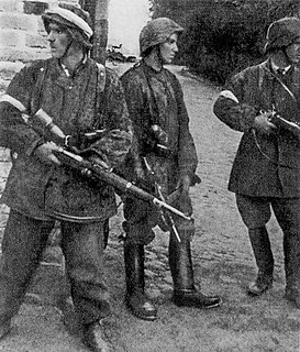
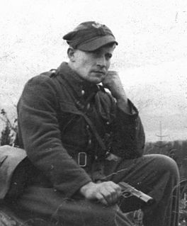
The Tatra Confederation, or Confederation of the Tatra Mountains, was a Polish resistance organization operating in the southernmost Podhale region during the Nazi German occupation of Poland. The Tatra Confederation was founded in May 1941 in Nowy Targ – the historical capital of Podhale, by the poet and partisan, Augustyn Suski ; with Tadeusz Popek as his deputy. The organization had its ideological roots in the peasant movement of the mountain region of interwar Poland.

Augustyn Suski Polish resistance fighter

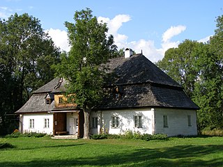
Augustyn Suski, was a Polish poet, pedagogue in the interwar period, and underground activist during World War II. Under the German occupation, Suski became a founder of the Polish resistance organization called Tatra Confederation, a.k.a. Confederation of the Tatra Mountains, operating in the Nowy Targ area of Podhale. He died at the Auschwitz concentration camp.

Jadwiga Apostoł Polish resistance fighter

Jadwiga Apostoł-Staniszewska was a Polish teacher in the interwar period, an underground activist during World War II, and a writer in postwar Poland.

References

Coordinates: 49°29′N20°5′E / 49.483°N 20.083°E / 49.483; 20.083

Geographic coordinate system Coordinate system

A geographic coordinate system is a coordinate system that enables every location on Earth to be specified by a set of numbers, letters or symbols. The coordinates are often chosen such that one of the numbers represents a vertical position and two or three of the numbers represent a horizontal position; alternatively, a geographic position may be expressed in a combined three-dimensional Cartesian vector. A common choice of coordinates is latitude, longitude and elevation. To specify a location on a plane requires a map projection.