If you can address this concern by improving, copyediting, sourcing, renaming, or merging the page, please edit this page and do so. You may remove this message if you improve the article or otherwise object to deletion for any reason. Although not required, you are encouraged to explain why you object to the deletion, either in your edit summary or on the talk page. If this template is removed, do not replace it.
The article may be deleted if this message remains in place for seven days, i.e., after 20:33, 15 August 2018 (UTC). If you created the article, please don't be offended. Instead, consider improving the article so that it is acceptable according to the deletion policy.PRODExpired+%5B%5BWP%3APROD%7CPROD%5D%5D%2C+concern+was%3A+not+notable%2C+third+class+road%2C+%5B%5BWP%3AHIGHWAYS%5D%5DExpired [[WP:PROD|prod]], concern was: not notable, third class road, WP:HIGHWAYS
Nominator: Please consider notifying the author/project: {{subst:proposed deletion notify|EN3-FG05|concern=not notable, third class road, [[WP:HIGHWAYS]]}} ~~~~
EN3-FG05, also known as EN3-FG5 and EN3-5, some signs posts as N3-5 or N3-FG05, the second part is of the Island of Fogo, highway name: Caminho de Fonte Aleixo e Achada Furna (Fonte Aleixo-Achada Furna Road), south of Achada Furna, remainder: Caminho de Pico e Caldeiras (Pico and Chã das Caldeiras) is one of the main roads of the island behind EN2-FG01 and EN3-FG02 (Lomba-Cova Figueira and runs primarily south-north). It does not just carry tourist and passenger traffic but carries primarily agricultural goods mainly to other parts of the island such as Chã das Caldeiras wine and other fruits. The northernmost portion was devastated by the recent eruption in November and December 2014, it was also partly devastated near Chã das Caldeiras during the April 1995 eruption. The national route is the highest in Cape Verde running at about 1,600 metres (5,200ft) elevation, other routes running at higher elevations in the nation are Porto Novo-Tarrafal de Monte Trigo Road and Estrada da Corda (Porto Novo-Corda-Ribeira Grande), both located on the island of Santo Antão. The route starts at Fonte Aleixo and finishes at Bangaeira in Chã das Caldeiras. Its total length is 25km, before the 2014–15 eruption, it was 19.8km long.
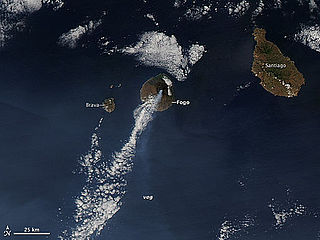
The 2014–15 eruption of Fogo, the eruption of the Pico do Fogo, was a minor eruption that began on 23 November 2014, it was less intensified on December 8, it became intensified on December 19 but decreased and would be finished on February 8. It was the next volcanic activity in 19 years and was the longest since the 1857 eruption, longer than the last previous two eruptions. According to the Volcanic Explosivity Index, it was measured 3, the first since records began.
Porto Novo is a city in the island of Santo Antão, in Cape Verde. It is the seat of the Porto Novo municipality. At the 2010 census, the town had 9,310 inhabitants, which makes it the most populous settlement of the island.
Tarrafal de Monte Trigo is a settlement in the southwestern part of the island of Santo Antão, Cape Verde. In 2010 its population was 841. It is situated on the coast, 27 km west of the island capital Porto Novo. The settlement was mentioned as Terrafal in the 1747 map by Jacques-Nicolas Bellin.
Route
The highway starts at the junction with Fogo Circular Road (EN1-ST01) in Fonte Aleixo at about 500 meters above sea level, a stretch that remains to be paved with cobblestone and its lanes are narrow. For a few hundred meters, it forms a joint with the road (EN3-FG01) connecting Cova Figueira and Lomba and runs into the center of Achada Furna at 850 meters above sea level. From that portion up to Cabeça Fundão at Bordeira, the road are paved with asphalt, first paved in the early 2000s and being the fewest on the island, the Circular Road and parts of the Cova Figueira-Lomba road are also paved with asphalt.
EN1-ST01 is a first class national road on the island of Santiago, Cape Verde. It runs from the capital Praia in the south to Tarrafal in the north, through the mountainous interior of the island. It is 61 km long. The main intersections are:
Fonte Aleixo is a settlement in the southern part of the island of Fogo, Cape Verde. It is situated 3 km south of Achada Furna and 16 km southeast of the island capital São Filipe. In 2010 its population was 401.
Cova Figueira is a city in the southeastern part of the island of Fogo, Cape Verde. In 2010 its population was 1,230, making it the most populated place in the municipality. It is situated 22 km east of the island capital São Filipe. Since 2005, it serves as the seat of Santa Catarina do Fogo Municipality. Its elevation is 480 meters above sea level. The volcano Pico do Fogo is 7.7 km to the northwest. Nearby places include Figueira Pavão in the southwest, Mãe Joana and Estância Roque in the west and Tinteira in the north. Cova Figueira was elevated to a city in 2010.
The route before lava flows covered it in late November 2014A stretch of highway heading uphill to Bordeira
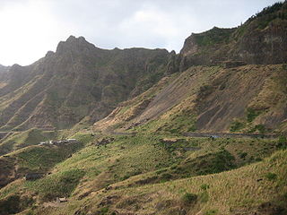
A stretch of highway has zig-zag and winding curves heading uphill and into 1,000 meters above sea level. It runs within several hills of volcanic origin along with a forested one that features a caldera. At that location, it offers panoramic views of Monte Fogo and also the southern portion of the island and rarely offers views of the nearby island of Brava. It slightly runs east before it runs north in Cabeça Fundão, also at that location, the paved section ends and the remainder are paved in local basalt. At 1,600 meters elevation, it runs in the eastern rim of Bordeira and curves to the west then north then west which encircles the west of the caldera and Pico da Caldeira for about 10–15km and enters the country's largest caldera (Portuguese: Caldeira do Fogo). A part of the road runs near the old stretch of the road.
A caldera is a large cauldron-like hollow that forms following the evacuation of a magma chamber/reservoir. When large volumes of magma are erupted over a short time, structural support for the crust above the magma chamber is lost. The ground surface then collapses downward into the partially emptied magma chamber, leaving a massive depression at the surface. Although sometimes described as a crater, the feature is actually a type of sinkhole, as it is formed through subsidence and collapse rather than an explosion or impact. Only seven known caldera-forming collapses have occurred since the start of the 20th century, most recently at Bárðarbunga volcano in Iceland.
Pico do Fogopronounced [ˈpiku du ˈfoɡu] is the highest peak of Cape Verde and West Africa, rising to 2,829 metres (9,281 ft) above sea level. It is an active stratovolcano lying on the island of Fogo. The main cone last erupted in 1680, causing mass emigration from the island. A subsidiary vent erupted in 1995. The only deadly eruption was in 1847 when earthquakes killed several people.
After entering the caldera it curves to the west and then north, it enters several hills made out of previous eruptions on the mountain. Just north of the crater rim known as Bordeira, the entry sign into Fogo Natural Park is posted. Until 2014, a stretch of highway was cobblestoned. After the last lava flow in December 2015, only the south portion remains. The highway is once again unpaved with dirt and runs on the rim of Bordeira for the rest of the length up to Portela and Bangaeira where much of the buildings were destroyed and some of its plants. 0 Before the 2014 eruption, the lava flow covered the road up to over 1km southeast of Monte Beco totalling over 4km, the highway once curved left then right just next to Pico Pequeno and a slight small curves were followed for the rest of the length, in between are a few earlier small volcanic craters where lava once flowed. The highway once entered Chã das Caldeiras and the subdivision of Portela, the village center and curved right. The highway forms a terminus, once at that different location.
Chã das Caldeiras is a small community of approximately 700 inhabitants in the crater of the volcano Pico do Fogo on the island of Fogo, Cape Verde. The village consists of two main parts: Portela and Bangaeira, founded in 1920 and 1917, respectively. At an elevation of about 1,700 meters, it is the highest village in Cape Verde. It is part of the municipality of Santa Catarina do Fogo. The main organizing body in the village is the Associação dos Agricultores de Chã, which holds considerable sway over the local economy. Chã is the only area in Cape Verde that grows significant quantities of grapes and produces export-quality wines.
History
About the mid to late 16th century, a small road was founded. Uncertain that the road was largely abandoned during the 1680 eruption. Recorded history had after Chã das Caldeiras was founded in 1870 by the Count of Montrond to grow wine grapes, the foundation date of Cabeça Fundão is unknown. The remaining stretch of the dirt road was completed just north of Achada Furna. The eruption of June 1951 nearly reached the road at the terminus in Bangaeira and by Bordeira near Cabeça Fundão.
The route that is today southwest of Monte Beco in Pico do Fogo, on the right, the road is now covered in lava flow and are buried underneath the lava bed.
Its road was first paved around the 1960s, in the early 2000s, the stretch from Achada Furna to Cabeça Fundão became paved with asphalt. A stretch of roads in the upper portion was devastated by two recent eruptions. The first lava flow was in April 1995 which ruined a stretch south of Portela for 1km and another was from November 2014 to December 2015.
In the first days of eruption on November 29,[1] lava reached the road near Pico Pequeno, lava flow was 15 meters an hour (320 meters a day) for a few days.[2] A day later, most of the southern stretch of highway was covered in lava except for a portion due west of Pico Pequeno. On December 4, it reached a stretch near the village center at Portela, on December 8, it reached the terminus at Bangaeira. On December 12, the remaining stretch south of Portela was covered in lava. During the eruption, the highway into the caldera was closed and remained for several months after the last lava flow until the route marking was relocated on the foot of Bordeira. In mid-December, the road would not be harmed by more lava flows. Further lava flows buried more of the road in areas of previous lava flows as it went west of Pico Pequeno for a few days in December 19. Lava flows later decreased and became less active and on February 8, it was finished.[3] Lava covered up to around 10 meters within Pico Pequeno, 4 meters in Portela and 1–2 meters at Bangaeira. Also, it covered around 5km of the road.
Minibus line
On the section inside Achada Furna, Aluguer buses connect Achada Furna but not on a fixed schedule during 6 days of the week but not on holidays, it once had a line that connected with Chã das Caldeiras, after the 2014–15 eruption, that line became eliminated.
Landmarks and features
In Chã das Caldeiras before the 2014 eruption, the road ran alongside the village school and the vineyard factory and offices. Notable architecture such as neoclassical and some funco hut-style houses were alongside the road in Portela and Bangaeira.
This page is based on this Wikipedia article Text is available under the CC BY-SA 4.0 license; additional terms may apply. Images, videos and audio are available under their respective licenses.