
The recorded history of Cape Verde begins with Portuguese discovery in 1456. Possible early references go back around 2000 years.

Pico Island, is an island in the Central Group of the Portuguese Azores. The landscape features an eponymous volcano, Ponta do Pico, which is the highest mountain in Portugal, the Azores, and the highest elevation of the Mid-Atlantic Ridge. In the tradition of the Portuguese poet, Raul Brandão, Pico is referred to as the Ilha Preta, for its black volcanic earth, responsible for its UNESCO-designated historical vineyards that allowed the development of the island.

São Miguel Island, nicknamed "The Green Island", is the largest and most populous island in the Portuguese archipelago of the Azores. The island covers 760 km2 (290 sq mi) and has around 140,000 inhabitants, with 45,000 people resident in Ponta Delgada, the archipelago's largest city.

Chã das Caldeiras is a small community of approximately 700 inhabitants in the crater of the volcano Pico do Fogo on the island of Fogo, Cape Verde. The village consists of two main parts: Portela and Bangaeira, founded in 1920 and 1917, respectively. At an elevation of about 1,700 meters, it is the highest village in Cape Verde. It is part of the municipality of Santa Catarina do Fogo. The main organizing body in the village is the Associação dos Agricultores de Chã, which holds considerable sway over the local economy. Chã is the only area in Cape Verde that grows significant quantities of grapes and produces export-quality wines.

Santiago is the largest island of Cape Verde, its most important agricultural centre and home to half the nation’s population. Part of the Sotavento Islands, it lies between the islands of Maio and Fogo. It was the first of the islands to be settled: the town of Ribeira Grande was founded in 1462. Santiago is home to the nation's capital city of Praia.

A somma volcano is a volcanic caldera that has been partially filled by a new central cone. The name comes from Mount Somma, a stratovolcano in southern Italy with a summit caldera in which the upper cone of Mount Vesuvius has grown.

Mosteiros is a concelho (municipality) of Cape Verde. Situated in the northeastern part of the island of Fogo, it covers 19% of the island area, and is home to 26% of its population. Its seat is the city Mosteiros (Igreja). Its population was 9,524 at the 2010 census, and its area is 89.45 km2.

Mount Pico is a stratovolcano located on Pico Island, in the mid-Atlantic archipelago of the Azores. It is the highest mountain of Portugal, at 2,351 metres (7,713 ft) above sea level, and is one of the highest Atlantic mountains; it is more than twice the elevation of any other peak in the Azores.

Cova Figueira is a city in the southeastern part of the island of Fogo, Cape Verde. In 2010 its population was 1,230, making it the most populated place in the municipality. It is situated 22 km east of the island capital São Filipe. Since 2005, it serves as the seat of Santa Catarina do Fogo Municipality. Its elevation is 480 meters above sea level. The volcano Pico do Fogo is 7.7 km to the northwest. Nearby places include Figueira Pavão in the southwest, Mãe Joana and Estância Roque in the west and Tinteira in the north. Cova Figueira was elevated to a city in 2010.

Cabeça Fundão is a settlement in the southern part of the island of Fogo, Cape Verde and sits on the foot of the mountain rim of Bordeira. It is situated 16 km east of the island capital São Filipe. In 2010 its population was 177. The village is located on the road from Achada Furna to Chã das Caldeiras (EN3-FG05). Its elevation is about 1,570 meters. Cabeça Fundão lies directly south of the Fogo Natural Park.

Cape Verde was a colony of the Portuguese Empire from the initial settlement of the Cape Verde Islands in 1462 until the independence of Cape Verde in 1975.
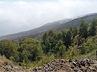
Monte Velha is a peak in the northeastern part of the island of Fogo in Cape Verde. Its elevation is 1,482 m. It is a subpeak of the Pico do Fogo volcano, located at the northeastern end of the crater rim. It lies within the municipality of Mosteiros, 4 km southwest of the city centre. Its forest is a protected area, part of the larger Fogo Natural Park.
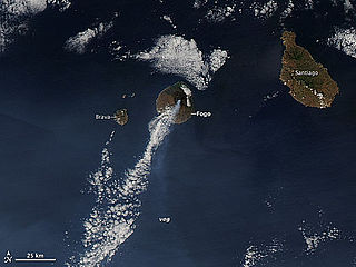
The 2014–15 eruption of Fogo, the eruption of the Pico do Fogo, was a minor eruption that began on 23 November 2014, it was less intensified on December 8, it became intensified on December 19 but decreased and would be finished on February 8. It was the next volcanic activity in 19 years and was the longest since the 1857 eruption, longer than the last previous two eruptions. According to the Volcanic Explosivity Index, it was measured 3, the first since records began.
The following lists events that happened during 1995 in Cape Verde.
The Fogo Island Cup is a regional cup competition and is played during the season in the island of Fogo, Cape Verde, it consists of all the clubs from all the two regional divisions and are divided into about four to five rounds, for some seasons, a group stage was featured. The cup competition is organized by the Fogo Regional Football Association .The cup winner competes in the regional super cup final in the following season when a cup winner also wins the championship, a runner-up competes. For several seasons, the winner qualified into Cape Verdean Cup which has been cancelled due to financial and scheduling reasons.
The 2017 Santiago South Super Cup was the annual and a single knockout match in the island of Fogo featuring the champion of the 2016-17 Premier Division Vulcânicos and the winner of the cup competition Académica do Fogo. The match also formed a part of the Vulcânicos–Académica do Fogo rivalry.


