Mindelo is a port city in the northern part of the island of São Vicente in Cape Verde. Mindelo is also the seat of the parish of Nossa Senhora da Luz, and the municipality of São Vicente. The city is home to 93% of the entire island's population. Mindelo is known for its colourful and animated carnival celebrations, with roots in Portuguese traditions.

Boa Vista, also written as Boavista, is a desert-like island that belongs to the Cape Verde Islands. At 631.1 km2 (243.7 sq mi), it is the third largest island of the Cape Verde archipelago.
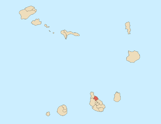
São Miguel is a concelho (municipality) of Cape Verde. It is situated in the northeastern part of the island of Santiago. Its seat is the city Calheta de São Miguel. Its population was 15,648 at the 2010 census, and its area is 77.4 km2. The municipality was created in 1996, when a parish of the older Municipality of Tarrafal was separated to become the Municipality of São Miguel.

Campo Baixo is a small settlement located in the southwestern part of the island of Brava, Cape Verde. In English, the name of the village means "low field". It is situated in the mountains, 1.5 km southwest of Nossa Senhora do Monte and 4 km southwest of the island capital Nova Sintra. From Nossa Senhora do Monte, Campo Baixo is accessible by "Aluguer" buses.

Achada Furna is a settlement in the southern part of the island of Fogo, Cape Verde. It is situated 15 km east of the island capital São Filipe. At the 2010 census its population was 495. Its elevation is about 870 meters. Nearby places include Cabeça Fundão to the north, Figueira Pavão to the east, Fonte Aleixo to the south and Monte Largo to the west.

Cova Figueira is a city in the southeastern part of the island of Fogo, Cape Verde. In 2010 its population was 1,230, making it the most populated place in the municipality. It is situated 22 km east of the island capital São Filipe. Since 2005, it serves as the seat of Santa Catarina do Fogo Municipality. Its elevation is 480 meters above sea level. The volcano Pico do Fogo is 7.7 km to the northwest. Nearby places include Figueira Pavão in the southwest, Mãe Joana and Estância Roque in the west and Tinteira in the north. Cova Figueira was elevated to a city in 2010.
Monte Grande is a settlement in the central part of the island of Fogo, Cape Verde. It is situated at about 900 m in elevation, 10 km east of the island capital São Filipe. In 2010 its population was 743. Nearby places include Monte Largo to the southeast, Patim to the southwest and Miguel Gonçalves to the northwest.
Trás os Montes is a settlement in the northern part of the island of Santiago, Cape Verde. In 2010 its population was 464. It is situated 4 km northeast of Tarrafal.
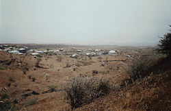
Achada Monte is a town in the northern part of the island of Santiago, Cape Verde and is part of the municipality of São Miguel. It is situated near the east coast, 8 km northwest of Calheta de São Miguel. In 2010 its population was 1,652. It is on the road connecting Praia and Tarrafal through Pedra Badejo, the EN1-ST02. The small bay Mangue de Sete Ribeiras is located east of the settlement. Ribeira Principal flows west of the village.
Monte Trigo is the westernmost settlement on the island of Santo Antão, Cape Verde. It is situated on the coast, at the foot of the Tope de Coroa, the highest mountain of the island. It is 28 km west of the island capital Porto Novo. In 2010 its population was 274. About 5 km to the northwest is Ponta do Chão de Mangrade, the westernmost point of all Africa.
Cabeçalinho is a settlement in the western part of the island of São Nicolau, Cape Verde. In 2010 its population was 155. It is situated 3 km southwest of Ribeira Brava and 6 km northeast of Tarrafal de São Nicolau. To its northwest is Monte Gordo.
Cachaço is a settlement in the northwestern part of the island of São Nicolau, Cape Verde. It is situated 3 km southwest of Fajã de Baixo and 5 km west of Ribeira Brava. It lies on the national road from Tarrafal de São Nicolau to Ribeira Brava (EN1-SN01). Cachaço lies at about 700 m elevation, at the northeastern foot of Monte Gordo, and partly within the Monte Gordo Natural Park. Several rivers have their source near Cachaço, including the north-flowing Ribeira Grande and the east-flowing Ribeira Brava.
Tarrafal de Monte Trigo is a settlement in the southwestern part of the island of Santo Antão, Cape Verde. In 2010 its population was 841. It is situated on the coast, 27 km west of the island capital Porto Novo. The settlement was mentioned as Terrafal in the 1747 map by Jacques-Nicolas Bellin.
Hortelã is a settlement in the western part of the island of São Nicolau, Cape Verde. In 2010 its population was 181. It is situated at the southern foot of Monte Gordo, 5 km north of Tarrafal de São Nicolau and 6 km west of Ribeira Brava.

Ribeira de Calhau is a settlement in the eastern part of the island of Sao Vicente, Cape Verde. It takes its name from the river Ribeira do Calhau, and comprises the villages of Madeiral, Ribeira de Calhau and Calhau. Madeiral and Ribeira de Calhau are located in the river valley, Calhau is on the east coast. In 2010 its population was 1,177. The valley is surrounded by the mountains Viana, Madeiral, Pico do Vento and Monte Verde.
Lagoa is a settlement in the central part of the island of Santo Antão, Cape Verde. In 2010 its population was 358. It is situated at about 1,200 m elevation on the eastern plateau of Santo Antão, 11 km northwest of the island capital Porto Novo. The Moroços Natural Park lies about 3 km west of Lagoa.
Ribeira dos Calhaus is a settlement in the western part of the island of São Nicolau, Cape Verde. It is part of the municipality of Tarrafal de São Nicolau. It is situated in a valley northwest of Monte Gordo, 3 km southeast of Praia Branca and 7 km north of Tarrafal de São Nicolau.
Luzia Nunes is a settlement in the southwestern part of the island of Fogo, Cape Verde. It is situated 1.5 km west of Patim, 2 km southeast of Vicente Dias and 7 km southeast of the island capital São Filipe. At the 2010 census its population was 438.
Monte Vermelho is a settlement in the southeastern part of the island of Fogo, Cape Verde. It is situated 3 km east of Fonte Aleixo, 3 km southwest of Figueira Pavão, 6 km southwest of Cova Figueira and 19 km southeast of the island capital São Filipe. At the 2010 census its population was 221. Its elevation is about 400 meters.