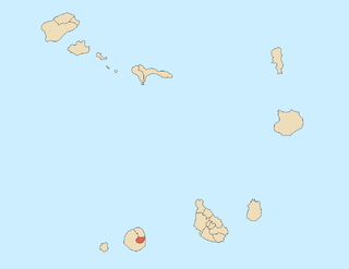
Santa Catarina do Fogo is a concelho (municipality) of Cape Verde. Situated in the southeastern part of the island of Fogo, it covers 32% of the island area, and is home to 14% of its population. Its seat is the city Cova Figueira. The Municipality of Santa Catarina do Fogo was created in 2005; before 2005, it was a parish of the Municipality of São Filipe.

Tantum or Lomba Tantum is a small settlement located in the southwest corner of the island Brava, Cape Verde. It is one of the southernmost settlements in Cape Verde, together with nearby Cachaço. Its 2010 population was 282. It sits at an elevation of 228 meters. It is situated in the mountains near the south coast, 6 km southwest of the island capital Nova Sintra.

Achada Furna is a settlement in the southern part of the island of Fogo, Cape Verde. It is situated 15 km east of the island capital São Filipe. At the 2010 census its population was 495. Its elevation is about 870 meters. Nearby places include Cabeça Fundão to the north, Figueira Pavão to the east, Fonte Aleixo to the south and Monte Largo to the west.
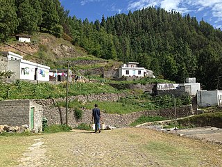
Cova Figueira is a city in the southeastern part of the island of Fogo, Cape Verde. In 2010 its population was 1,230, making it the most populated place in the municipality. It is situated 22 km east of the island capital São Filipe. Since 2005, it serves as the seat of Santa Catarina do Fogo Municipality. Its elevation is 480 meters above sea level. The volcano Pico do Fogo is 7.7 km to the northwest. Nearby places include Figueira Pavão in the southwest, Mãe Joana and Estância Roque in the west and Tinteira in the north. Cova Figueira was elevated to a city in 2010.
Figueira Pavão is a settlement in the southeastern part of the island of Fogo, Cape Verde. In 2010 its population was 320. It is situated 3 km southwest of Cova Figueira and 20 km east of the island capital São Filipe. Nearby settlements are Achada Furna to the west and Estância Roque to the north.
Estância Roque is a settlement in the eastern part of the island of Fogo, Cape Verde. In 2010 its population was 411. It is situated 3 km west of Cova Figueira and 19 km east of the island capital São Filipe. Nearby places include Figueira Pavão in the south and Cabeça Fundão in the northwest.
Galinheiro is a settlement in the northwestern part of the island of Fogo, Cape Verde. In 2010 its population was 877. It is situated 2 km northeast of Ponta Verde, 2.5 km southwest of São Jorge and 13 km northeast of the island capital São Filipe.
Figueira das Naus is a settlement in the western part of the island of Santiago, Cape Verde. It is part of the municipality of Santa Catarina. In 2010 its population was 1,157. It is situated 11 km south of Tarrafal and 12 km northwest of Assomada. It is situated on the secondary road connecting Fundura and Ribeira da Prata.
Eito is a village in the northeastern part of the island of Santo Antão, Cape Verde, part of the municipality of Paul. It is situated 1 km southwest of Pombas, 2 km northeast of Figueiral and 15 km northeast of the island capital Porto Novo. Its population was 979 in 2010.
Cabeçalinho is a settlement in the western part of the island of São Nicolau, Cape Verde. In 2010 its population was 155. It is situated 3 km southwest of Ribeira Brava and 6 km northeast of Tarrafal de São Nicolau. To its northwest is Monte Gordo.
Figueiras is a settlement in the northern part of the island of Santo Antão, Cape Verde. It is situated in a mountain valley, 20 km northwest of the island capital Porto Novo. The southernmost part lies in Moroços Natural Park.

Cabeça dos Tarrafes is a village in the eastern part of the island of Boa Vista, Cape Verde. The village is located about 2 km south of Fundo das Figueiras and 21 km southeast of the island capital of Sal Rei. It is one of the easternmost communities in Cape Verde.

Fundo das Figueiras is a village in the eastern part of the island of Boa Vista. The village is around 21 km east of the island capital of Sal Rei. It is the seat of the civil parish of São João Baptista. 2 km to the south is the village Cabeça dos Tarrafes and 8 km southeast is Ponta Meringuel, the easternmost point in Cape Verde.

João Galego is a village in the northeastern part of the island of Boa Vista, Cape Verde. Its population was 346 at the 2010 census. The village is around 2 km northwest of Fundo das Figueiras and 19 km east of the island capital of Sal Rei.
Figueira is a settlement in the southern part of the island of Maio. It consists of the villages Figueira da Horta and Figueira Seca. Figueira is 7 km east of the island capital Porto Inglês. As of the 2010 census, its population was 529. It sits at 40 meters above sea level.
Pico da Cruz is a settlement in the northeastern part of the island of Santo Antão, Cape Verde. In 2010 its population was 138. It is situated 6 km southwest of Pombas and 10 km northeast of the island capital Porto Novo. Its elevation is about 1,400 meters. The village is named after the nearby mountain Pico da Cruz. It lies in the Cova-Paul-Ribeira da Torre Natural Park.

Tinteira is a settlement in the eastern part of the island of Fogo, Cape Verde. It is situated 4 km north of Cova Figueira, 5 km south of Relva and 22 km east of the island capital São Filipe. At the 2010 census its population was 410. Its elevation is 300 meters. Tinteira consists of the localities Tinteira, Cova Matinho and Cutelo Capado.
Figueira Muita is a settlement in the northern part of the island of Santiago, Cape Verde. It is part of the municipality of Tarrafal. In 2010 its population was 160. It is located about 2 km south of Ribeira da Prata and 8 km south of Tarrafal.
Lombo de Figueira is a settlement in the eastcentral part of the island of Santo Antão, Cape Verde, part of the municipality of Porto Novo and the parish of São João Baptista. In 2010 its population was 281. It is situated about 9 km north of the island capital Porto Novo, on the national road from Porto Novo to Ribeira Grande (EN1-SA01). Subdivisions include Água das Caldeiras and Chã de Tampa. An endemic species of butterflies, Leptotes pirithous capverti, has been found in the area.
Figueiral is a settlement in the eastern part of the island of Santo Antão, Cape Verde. In 2010 its population was 591. It is part of the municipality of Paul. It is situated in the valley of the Ribeira do Figueiral, a tributary of the Ribeira do Paul, 2 km southwest of Eito and 3 km southwest of Pombas.


