Related Research Articles

The Cypress Hills are a geographical region of hills in southwestern Saskatchewan and southeastern Alberta, Canada. The hills are part of the Missouri Coteau upland.
Eagle Butte is an impact crater in Alberta, Canada, named for a rural area west of the Cypress Hills.

Seven Persons is a hamlet in Alberta, Canada within Cypress County. It is located approximately 20 kilometres (12 mi) southwest of Medicine Hat on Highway 3 and has an elevation of 755 metres (2,477 ft).
Elkwater is an unincorporated community at the western edge of the Cypress Hills in southeastern Alberta, Canada, 65 kilometres (40 mi) southeast of Medicine Hat. The main access route is via Alberta Highway 41, which leads south from the Trans-Canada Highway.
Redcliff is a town in southern Alberta, Canada. Adjacent to the City of Medicine Hat to the east and Cypress County to the west and north, the town is bisected by Highway 1 and is located on the north bank of the South Saskatchewan River.
Cypress-Medicine Hat is a provincial electoral district in the southeast corner of Alberta.

Picture Butte is a town in southern Alberta, Canada. It is located 27 km (17 mi) north of the city of Lethbridge. It claims the title of "Livestock Feeding Capital of Canada."
Irvine is a hamlet in Alberta, Canada within Cypress County. It is located approximately 35 kilometres (22 mi) east of Medicine Hat on Highway 1 and has an elevation of 763 metres (2,503 ft). The hamlet is located in census division No. 1 and in the federal riding of Medicine Hat.
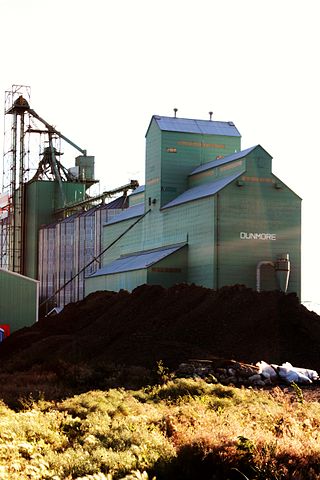
Dunmore is a hamlet in Alberta, Canada within Cypress County, located 2.6 kilometres (1.6 mi) southeast of Medicine Hat's city limits on Highway 1 and the Canadian Pacific Railway mainline. A portion of the hamlet is recognized as a designated place by Statistics Canada.
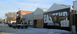
Eastend is a town in south-west part of the Canadian province of Saskatchewan, situated approximately 55 kilometres (34 mi) north of the Montana border and 85 kilometres (53 mi) east of the Alberta border.
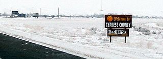
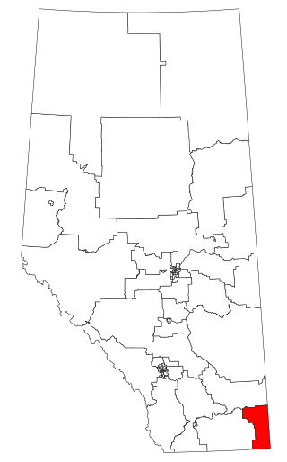
Cypress County is a municipal district in southeastern Alberta, Canada that surrounds the City of Medicine Hat and the Town of Redcliff. The municipality is part of Census Division 1, Alberta. The first farm in the area was settled in 1890.

Butte des Morts is an unincorporated census-designated place in the town of Winneconne, in Winnebago County, Wisconsin, United States.

Twin Butte is a hamlet in Southern Alberta, Canada within the Municipal District of Pincher Creek No. 9. It is located on Highway 6, approximately 88 kilometres (55 mi) southwest of Lethbridge. The hamlet of Twin Butte is historically known as a small ranching community located in the foothills of Alberta's Southwest region. The community has a general store, post office, Restaurant and a community hall along Highway 6 north of Township Road 40.
Wild Horse is an unincorporated community in southern Alberta within Cypress County, Canada on the Canada–United States border. It is located on Highway 41, approximately 120 km (75 mi) southeast of Medicine Hat.
The Ravenscrag Formation is a stratigraphic unit of early Paleocene age in the Western Canada Sedimentary Basin. It was named for the settlement of Ravenscrag, Saskatchewan, and was first described from outcrops at Ravenscrag Butte near the Frenchman River by N.B. Davis in 1918.
The Cypress Hills Formation is a stratigraphic unit of middle Eocene to early Miocene age in the Western Canada Sedimentary Basin. It is named for the Cypress Hills of southeastern Alberta and southwestern Saskatchewan and was first described from outcrops on the slopes of the Cypress Hills in 1930. It is known for preserving a wealth of vertebrate fossils.
The Whitemud Formation is a geologic formation of Late Cretaceous (Maastrichtian) age in the Western Canada Sedimentary Basin. it is present through the plains of southern Saskatchewan, southeastern Alberta and south-central Alberta. Named by N.B. Davis in 1918, the formation is characterized by white kaolinitic clay and is a source of high-quality refractory clay. The type locality has been designated as Dempster's clay pit northwest of Eastend, Saskatchewan.
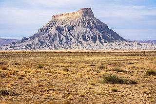
Factory Butte in Wayne County, Utah is a 6,302-foot (1,921 m) summit in the Upper Blue Hills in northern Wayne County, Utah, United States, about 12 miles (19 km) northwest of Hanksville and about 14 miles (23 km) east of Capitol Reef National Park boundary.
Prairie Creek is a stream in Crawford County in the U.S. state of Missouri. It is a tributary of Brush Creek.
References
- ↑ Cypress Hills (Alberta) Historical Society (1991). Cypress Hills country. Elkwater, Alberta: Cypress Hills (Alberta) Historical Society. p. 47. ISBN 0-88925-918-6.
- ↑ Place-names of Alberta. Ottawa: Geographic Board of Canada. 1928. p. 46.
Coordinates: 49°36′18″N110°26′02″W / 49.60500°N 110.43389°W
| | This Southern Alberta location article is a stub. You can help Wikipedia by expanding it. |