Nichols Field was a U.S. military airfield located south of Manila in Pasay and Parañaque, Metro Manila, Luzon, the Philippines. The complex is located at Andrews Avenue by the north, Domestic Road by the west, NAIA Road and Ninoy Aquino Avenue by the southwest, Multinational Avenue by the south, South Luzon Expressway and the Metro Manila Skyway by the east, and Sales Street by the northeast.
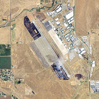
Chico Regional Airport, formerly known as Chico Municipal Airport, is four miles (6 km) north of Chico, in Butte County, California, United States. The airport covers 1,475 acres (6.0 km2), has two runways and one helipad. Its fixed-base operator, Northgate Aviation provides fuel, maintenance, flight training, and charter flights. Though an operational airport with that meets Federal Aviation Regulations Part 139 standards, the airport has not seen active commercial air service since SkyWest Airlines ended service to San Francisco at the end of 2014.

The 12th Reconnaissance Squadron was a United States Air Force squadron, assigned to the 319th Operations Group at Grand Forks Air Force Base, North Dakota, and operates from Beale Air Force Base, California.

Ellington Field Joint Reserve Base is a joint installation shared by various active component and reserve component military units, as well as aircraft flight operations of the National Aeronautics and Space Administration (NASA) under the aegis of the nearby Johnson Space Center. The host wing for the installation is the Texas Air National Guard's 147th Attack Wing. Opened in 1917, Ellington Field was one of thirty-two Air Service training camps established after the United States entry into World War I. It is named for First Lieutenant Eric Ellington, a U.S. Army aviator who was killed in a plane crash in San Diego, California in 1913.

Daniel Field is a public use airport located one nautical mile (2 km) west of the central business district of Augusta, a city in Richmond County, Georgia, United States. It is owned by the City of Augusta and operated by the General Aviation Commission. This airport is included in the National Plan of Integrated Airport Systems for 2021–2025, which categorized it as a general aviation facility.

Statesboro–Bulloch County Airport is a public airport located three miles (5 km) northeast of the central business district of Statesboro, a city in Bulloch County, Georgia, United States. It is owned by the City of Statesboro and Bulloch County. Currently, there is no commercial service to the airport.

The United States Air Force's 101st Intelligence Squadron, Massachusetts Air National Guard, is an intelligence unit assigned to the 102nd Intelligence Wing and located at Otis Air National Guard Base, Massachusetts. From its creation in 1921 to its mission change in 2008, the 101st was the mainstay of aerospace defence for the Northeastern United States. The 101st was deployed during the Berlin Crisis to France and was also deployed to Panama during Operation Coronet Nighthawk. It also participated in Operation Northern Watch. During the September 11 attacks, the 101st was the first Air Force unit to send aircraft toward New York City, but they arrived too late to help stop the attacks.

The 8th Special Operations Squadron is a squadron of the United States Air Force. It is assigned to the 1st Special Operations Wing, Air Force Special Operations Command, stationed at Hurlburt Field, Florida. The squadron is equipped with the Bell Boeing CV-22 Osprey in support of special operations.

The 90th Fighter Squadron is a squadron of the United States Air Force. It is assigned to the 3rd Operations Group, based out of Joint Base Elmendorf–Richardson in Alaska and part of the Pacific Air Forces. The squadron is equipped with the F-22 Raptor fighter aircraft.

Grand Central Airport is a former airport in Glendale, California. Also known as Grand Central Air Terminal (GCAT), the airport was an important facility for the growing Los Angeles suburb of Glendale in the 1920s and a key element in the development of United States aviation. The terminal, located at 1310 Air Way, was built in 1928 and still exists, owned since 1997 by The Walt Disney Company as a part of its Grand Central Creative Campus (GC3). Three hangars also remain standing. The location of the single concrete 3,800-foot (1,200 m) runway has been preserved, but is now a public street as the runway was dug up and converted into Grand Central Avenue.

Dalhart Army Air Base is a former World War II military airfield complex near the city of Dalhart, Texas. It operated three training sites for the United States Army Air Forces from 1943 until 1945.

Smith Field is a public airport north of downtown Fort Wayne, in Allen County, Indiana. It is owned and operated by the Fort Wayne Allen County Airport Authority. In the FAA's National Plan of Integrated Airport Systems for 2009–2013 it is a general aviation airport. The airport was listed on the National Register of Historic Places in 2002.

The 3rd Operations Group is the operational flying component of the United States Air Force 3rd Wing. It is stationed at Joint Base Elmendorf–Richardson, Alaska, and is assigned to Pacific Air Forces' Eleventh Air Force.

Val Verde County Airport is a former airport, located in Del Rio, Texas. Airport operations ended in 1959. Today the former airport is a residential site.

Eagle Pass Army Airfield is a former World War II military airfield complex. It is located 10.6 miles (17.1 km) north of Eagle Pass, Texas. It operated as a training base for the United States Army Air Forces from 1943 until 1945.

Columbus Municipal Airport is an abandoned airport in New Mexico. Its origins date to 1916 when it was used by the Aviation Section, U.S. Signal Corps as a military airfield during the Pancho Villa Expedition. It was apparently closed and abandoned in the late 1970s. Today, efforts are being made to restore it to a general aviation airport.

Sanderson Field is a former military airfield, located in Sanderson, Texas. It was used by the 90th Squadron (Surveillance) between 1919 and 1921.

Marfa Airport is a former airport, located 2 miles Northeast of Marfa, Texas. Airport operations ended in 1945.

With the end of World War I in 1918, the Air Service, United States Army was largely demobilized. During the demobilization period of 1919, the Regular Army and its air arm answered a call to defend the southern border against raids from Mexico, and to halt smuggling of illegal aliens and narcotics into the United States and weapons from the United States into Mexico.

Merced Army Air Field auxiliary fields were built to support pilot training at the Merced Army Air Field. In 1940 the US Army wanted to build near Merced, California a 30,000 per year basic pilot training base. The former city of Cuba, Merced County, California near the Atchison, Topeka and Santa Fe Railway rail line was chosen at 37°22′50″N120°34′05″W at an elevation of 181 feet (55 m) for the main base, in Atwater, California. United States Army Air Corps leased the land from the City of Merced on 16 June 1941. Building the airbase school started on 8 July 1941 and opened on 20 September 1941 as a sub-base of Army Air Forces Western Flying Training Command at Moffett Field. First called Air Corps Basic Flying School, Merced. The US Army moved part of the: 98th Bombardment Group, 539th School Squadrons, 540th School Squadrons, 541st School Squadrons, the 90th Air Base Squadron, and the 340th Material Squadron at Moffett Field to the new base in November 1941. The Air Corps Basic Flying School was renamed the Merced Army Flying School on 7 April 1942. To support the training auxiliary fields near the Merced Army Flying School were to be built for the flight training program. Merced Army Flying School was renamed the Merced Army Air Field in May 1943 and became part of the Western Flying Training Command.