
Mount Whitney is the tallest mountain in California, as well as the highest summit in the contiguous United States and the Sierra Nevada—with an elevation of 14,505 feet (4,421 m). It is in Central California, on the boundary between California's Inyo and Tulare counties, 84.6 miles (136.2 km) west-northwest of the lowest point in North America at Badwater Basin in Death Valley National Park at 282 ft (86 m) below sea level. The west slope of the mountain is in Sequoia National Park and the summit is the southern terminus of the John Muir Trail which runs 211.9 mi (341.0 km) from Happy Isles in Yosemite Valley. The east slope is in the Inyo National Forest in Inyo County.

Mount Ritter is the highest mountain in Madera County, California, in the Western United States, at an elevation of 13,149 feet (4,008 m). It is also the highest and most prominent peak of its namesake, the Ritter Range, a subrange of the Sierra Nevada in the Ansel Adams Wilderness of the Inyo and Sierra National Forests. Mount Ritter is the 15th highest mountain peak in California with at least 500 meters of topographic prominence.

Junipero Serra Peak is the highest mountain in the Santa Lucia Mountains of California. It is also the highest peak in Monterey County. It is named after Franciscan Friar Junípero Serra, founder of the California Missions.
Castle Peak is the ninth highest summit of the Rocky Mountains of North America and the U.S. state of Colorado. The prominent 14,279-foot (4352.2 m) fourteener is the highest summit of the Elk Mountains and the Maroon Bells-Snowmass Wilderness. The peak is located 11.6 miles (18.7 km) northeast by north of the Town of Crested Butte, Colorado, United States, on the drainage divide separating Gunnison National Forest and Gunnison County from White River National Forest and Pitkin County. The summit of Castle Peak is the highest point of both counties.

Cedarville is a census-designated place located 20 miles (32 km) east of Alturas, at an elevation of 4,652 feet (1,418 m), in Modoc County, California.

Eagle Mountain is the highest natural point in Minnesota, United States, at 2,301 feet (701 m). It is in northern Cook County, in the Boundary Waters Canoe Area Wilderness and Superior National Forest in the Misquah Hills, northwest of Grand Marais. It is a Minnesota State Historic Site.

The Modoc National Forest is a 1,654,392-acre (6,695 km2) national forest in northeastern California.

Black Mountain is a summit in the Cleveland National Forest of the Peninsular Ranges in eastern San Diego County, California, north of Ramona. The peak is measured at 4,048 feet (1,234 m), and is sometimes referenced as Big Black Mountain to distinguish it from the smaller Rancho Peñasquitos Black Mountain Open Space Park in the city of San Diego. Black Mountain offers a WX channel for people who wish to tune in on radios to hear the weather; channel is located on VHF frequency 162.4000 MHz.

The King Range is a mountain range of the Outer Northern California Coast Ranges System, located entirely within Humboldt County on the North Coast of California.

Frazier Mountain is a broad, pine-forested peak in the Transverse Ranges System, within the Los Padres National Forest in northeastern Ventura County, California. At 8,017 feet (2,444 m), Frazier Mnt. is the sixteenth-highest mountain in the Transverse Ranges of Southern California.
Eagle Peak is the name of 44 mountain peaks of the United States including:

Mount Eddy is the highest peak of the Trinity Mountains, a mountain range of the Klamath Mountains System, located in Siskiyou County, and Trinity County in northern California.

Hat Mountain is a mountain located in the Warner Mountains south of Eagle Peak in California. The peak, which rises to an elevation of 8,741 feet (2,664 m), is the highest point in Lassen County. Lost Lake is located to the northwest of the summit. Most of the precipitation that falls on Hat Mountain is snow due to the high elevation.
Mount Ingalls is a mountain located in the Northern Sierra Nevada in California. The peak rises to an elevation of 8,376 feet (2,553 m), and is the highest point in Plumas County and Plumas National Forest. Most of the precipitation that falls on the mountain is snow due to the high elevation.
Hot Springs Mountain is a peak located in the Peninsular Ranges in California. The mountain rises to an elevation of 6,535 feet (1,992 m) and is the highest point in San Diego County. Some snow falls on the mountain peak during winter. It is located in a remote region of the county, 4 miles from the community of Warner Springs, 12 miles from Borrego Springs, and 50 miles from San Diego. The mountain and its immediate surroundings belong to the Los Coyotes Band of Cahuilla and Cupeno Indians. As of 2011, the mountain can be accessed via a gated dirt road, and prospective hikers are admitted to the reservation subject to a nominal entry fee.

Freel Peak is a mountain located in the Carson Range, a spur of the Sierra Nevada, near Lake Tahoe in California.

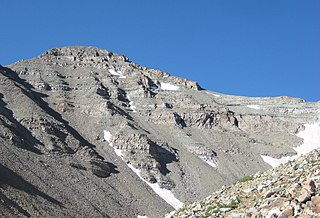
The South Warner Wilderness is a federally designated wilderness area 12 miles (19 km) east of Alturas, California, USA. It encompasses more than 70,000 acres (283 km2) of the Warner Mountains. It is within the Modoc National Forest and managed by the US Forest Service. Elevations range from 5,000 feet (1,500 m) to 9,895 feet at Eagle Peak.
The Cucamonga Wilderness is a federally designated wilderness area located in the eastern San Gabriel Mountains, in San Bernardino County, Southern California.


