M-26 is a 96.355-mile-long (155.068 km) state trunkline highway in the U.S. state of Michigan, running from two miles (3.2 km) east of Rockland to its junction with US Highway 41 (US 41) in Copper Harbor. It generally runs southwest-to-northeast in the western half or Michigan's Upper Peninsula. The northernmost segment, which closely parallels the shore of Lake Superior on the west side of the Keweenaw Peninsula, is highly scenic.

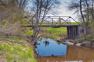
A truss bridge is a bridge whose load-bearing superstructure is composed of a truss, a structure of connected elements, usually forming triangular units. The connected elements, typically straight, may be stressed from tension, compression, or sometimes both in response to dynamic loads. There are several types of truss bridges, including some with simple designs that were among the first bridges designed in the 19th and early 20th centuries. A truss bridge is economical to construct primarily because it uses materials efficiently.

Eagle River is an unincorporated community and census-designated place (CDP) in the U.S. state of Michigan. It is the county seat of Keweenaw County. Its population was 65 at the 2020 census, which makes it by far the least-populated county seat in the state of Michigan. As an unincorporated community, Eagle River has no legal autonomy and is part of Allouez Township and Houghton Township.

The Port Deposit Bridge was the earliest bridge crossing of the Susquehanna River below Columbia, Pennsylvania, providing the first reliable link between the northern and southern United States. The bridge was also the fifth and last of Theodore Burr's Susquehanna crossings. The wooden covered bridge was constructed just north of Port Deposit, Maryland, between 1817 and 1818 and lasted until 1857. It was built and operated by the Susquehanna Bridge and Bank Company.

The Hampden County Memorial Bridge is a reinforced-concrete arch bridge that spans the Connecticut River between Springfield, Massachusetts and West Springfield, Massachusetts, constructed in 1922. The bridge is owned by Massachusetts Highway Department. It spans 209 feet (64 m) and rises 29.71 feet (9.06 m) above the river.

The Fairfax Bridge is a steel-lattice three-hinged arch bridge spanning the Carbon River on State Route 165 in Pierce County, Washington. Previous to the construction of the bridge in 1921, the only route south to the area around Fairfax was by train. At a total cost of $80,000, the bridge's deck sits 250 feet (76 m) above the river. Being a single-lane bridge, vehicles must yield to oncoming traffic already on the bridge.

US Highway 41 (US 41) is a part of the United States Numbered Highway System that runs from Miami, Florida, to the Upper Peninsula of the US state of Michigan. In Michigan, it is a state trunkline highway that enters the state via the Interstate Bridge between Marinette, Wisconsin, and Menominee, Michigan. The 278.769 miles (448.635 km) of US 41 that lie within Michigan serve as a major conduit. Most of the highway is listed on the National Highway System. Various sections are rural two-lane highway, urbanized four-lane divided expressway and the Copper Country Trail National Scenic Byway. The northernmost community along the highway is Copper Harbor at the tip of the Keweenaw Peninsula. The trunkline ends at a cul-de-sac east of Fort Wilkins State Park after serving the Central Upper Peninsula and Copper Country regions of Michigan.

The 19th Street Bridge is a two-span through Pratt truss road bridge in Denver, Colorado, over the South Platte River, now used for pedestrians. It was built in 1888 to replace a wooden structure and carried automobile traffic until 1986. The bridge is listed on the National Register of Historic Places.

The Jackson Branch Bridge No. 15, also known as the Tecumseh Railroad Bridge due to its close proximity to the city of Tecumseh, is a historic railway deck truss bridge that spans the River Raisin in rural Raisin Charter Township in Lenawee County, Michigan. The bridge was added to the National Register of Historic Places on December 4, 2001.
The Old M-95–Michigamme River Bridge is a bridge located on Old M-95 as it passes over the Michigamme River in Republic Township, Michigan. It was listed on the National Register of Historic Places in 1999.

The M-28–Sand River Bridge is a bridge located on M-28 over the Sand River in Onota Township, Michigan. It was listed on the National Register of Historic Places in 1999.

The Canyon Falls Bridge is a bridge located on US Highway 41 (US 41) over the Sturgeon River in L'Anse Township, Michigan. It was listed on the National Register of Historic Places in 1999.

The Lake Shore Drive Bridge, also known as the M-26 Bridge or the Eagle River Bridge, is a pedestrian bridge in Eagle River, Michigan, crossing the Eagle River. It carried highway M-26 over the river from 1915 until 1990, when the adjacent Eagle River Timber Bridge replaced it for automobile traffic. The Lake Shore Drive Bridge is listed as a Michigan State Historic Site and is a contributing property of the Eagle River Historic District.

The Parker Road–Charlotte River Bridge, also known as the 10 Mile Road–Charlotte River Bridge, is a bridge building located on Parker Road over the Charlotte River in Bruce Township, Michigan. It was listed on the National Register of Historic Places in 2000.

The US 12–St. Joseph River Bridge is a three-span camelback bridge in Mottville, Michigan, that carried U.S. Route 12 across the St. Joseph River. Built in 1922, it is the fourth bridge to cross the river at this location. It has served as a pedestrian bridge since 1990 when a new bridge opened alongside to carry the highway. The bridge is the longest surviving camelback bridge in Michigan. It is a Michigan State Historic Site and is listed on the National Register of Historic Places.
The US 31–Pentwater River Bridge is a three-span steel bridge that carries Oceana Drive over the Pentwater River in northern Hart, Michigan. It is listed on the National Register of Historic Places.

The Lincoln Covered Bridge is a historic covered bridge, just south of U.S. Route 4 in West Woodstock, Vermont. Built in 1877, it is one of the only known examples of a wooden Pratt truss bridge in the United States. It was listed on the National Register of Historic Places in 1973.

Bridge No. 3589 in Silver Creek Township, Minnesota is a reinforced concrete arch bridge carrying Minnesota State Highway 61 over the Stewart River just north of Two Harbors, Minnesota. The bridge was built in 1924, originally with a 70 feet (21 m) span and a width of 19 feet (5.8 m). It was widened to 39 feet (12 m) in 1939 because of increasing traffic loads. The bridge was listed on the National Register of Historic Places in 1998.

The Thornapple River Drive Bridge is a road bridge in Cascade Township, Michigan, carrying Thornapple River Drive over the Thornapple River. It was listed on he National Register of Historic Places in 1990.


