
M-26 is a 96.355-mile-long (155.068 km) state trunkline highway in the U.S. state of Michigan, running from two miles (3.2 km) east of Rockland to its junction with US Highway 41 (US 41) in Copper Harbor. It generally runs southwest-to-northeast in the western half or Michigan's Upper Peninsula. The northernmost segment, which closely parallels the shore of Lake Superior on the west side of the Keweenaw Peninsula, is highly scenic.

A truss bridge is a bridge whose load-bearing superstructure is composed of a truss, a structure of connected elements, usually forming triangular units. The connected elements, typically straight, may be stressed from tension, compression, or sometimes both in response to dynamic loads. There are several types of truss bridges, including some with simple designs that were among the first bridges designed in the 19th and early 20th centuries. A truss bridge is economical to construct primarily because it uses materials efficiently.

The Cambie Bridge is a six-lane, precast, box girder bridge spanning False Creek in Vancouver, British Columbia. The current bridge opened in 1985, but is the third bridge at the same location. Often referred to as the Cambie Street Bridge, it connects Cambie Street on the south shore of False Creek to both Nelson and Smithe Streets in the downtown peninsula. It is the easternmost of False Creek's fixed crossings; the Burrard and Granville bridges are a little more than a kilometre to the west, and the new Canada Line SkyTrain tunnel is built just west of the Cambie Bridge.
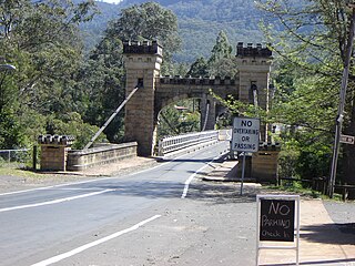
Hampden Bridge is a heritage-listed single-span suspension bridge that carries Moss Vale Road (B73) across the Kangaroo River, in Kangaroo Valley, in the City of Shoalhaven local government area of New South Wales, Australia. The bridge was designed by Ernest de Burgh and built by Loveridge and Hudson. The property is owned by Transport for NSW. It was added to the New South Wales State Heritage Register on 2 August 2019.

The Milton–Madison Bridge is a continuous truss bridge that connects Milton, Kentucky and Madison, Indiana. It carries approximately 10,000 cars a day.

The Tower Bridge is a vertical lift bridge across the Sacramento River, linking West Sacramento in Yolo County to the west, with the capital of California, Sacramento, in Sacramento County to the east. It has also been known as M Street Bridge. It was previously a part of U.S. Route 40 until that highway was truncated to east of Salt Lake City as well as US Route 99W, which served the western portion of the Sacramento Valley from Sacramento to Red Bluff. The bridge is maintained by the California Department of Transportation as part of State Route 275 and connects West Capitol Avenue and Cabaldon Parkway in West Sacramento with the Capitol Mall in Sacramento.

The Ada Covered Bridge is a 125-foot (38 m) span Brown truss covered bridge erected in 1867 in Ada, Michigan, United States. Carrying Bronson Street across the Thornapple River, it is located just south of where the Thornapple enters the Grand River, in turn just south of M-21. It is listed on the National Register of Historic Places.

Fallasburg Bridge is a 100-foot (30 m) span Brown truss covered bridge, erected in 1871 in Vergennes Township, Michigan, United States, 5 miles (8.0 km) north of Lowell on the Flat River. Carrying Covered Bridge Road across the Flat, it is located in the Fallasburg Historical District south of Whites Bridge and Smyrna. It is listed on the National Register of Historic Places, and along with Whites Bridge, Langley Covered Bridge, and Zehnder's Holz Brucke, is one of only four Michigan covered bridges open to vehicle traffic.

US Highway 41 (US 41) is a part of the United States Numbered Highway System that runs from Miami, Florida, to the Upper Peninsula of the US state of Michigan. In Michigan, it is a state trunkline highway that enters the state via the Interstate Bridge between Marinette, Wisconsin, and Menominee, Michigan. The 278.769 miles (448.635 km) of US 41 that lie within Michigan serve as a major conduit. Most of the highway is listed on the National Highway System. Various sections are rural two-lane highway, urbanized four-lane divided expressway and the Copper Country Trail National Scenic Byway. The northernmost community along the highway is Copper Harbor at the tip of the Keweenaw Peninsula. The trunkline ends at a cul-de-sac east of Fort Wilkins State Park after serving the Central Upper Peninsula and Copper Country regions of Michigan.
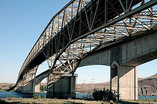
The Umatilla Bridge is the collective name for a pair of bridges in the northwest United States, carrying Interstate 82/U.S. Route 395 (I-82/US 395) across the Columbia River at the Washington–Oregon border. The older bridge opened in July 1955 and is a steel through truss cantilever bridge and carries southbound traffic. Northbound traffic and pedestrians travel on the newer concrete arch bridge, opened in 1988.

The 19th Street Bridge is a two-span through Pratt truss road bridge in Denver, Colorado, over the South Platte River, now used for pedestrians. It was built in 1888 to replace a wooden structure and carried automobile traffic until 1986. The bridge is listed on the National Register of Historic Places.

The Jackson Branch Bridge No. 15, also known as the Tecumseh Railroad Bridge due to its close proximity to the city of Tecumseh, is a historic railway deck truss bridge that spans the River Raisin in rural Raisin Charter Township in Lenawee County, Michigan. The bridge was added to the National Register of Historic Places on December 4, 2001.
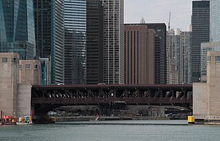
The Outer Drive Bridge, also known as the Link Bridge, is a double-deck bascule bridge carrying DuSable Lake Shore Drive across the Chicago River in Chicago, Illinois, United States. Construction was started in 1929 and was completed in 1937 as one of the Public Works Administration's infrastructure projects in Chicago. Completion of the bridge tied the north and south sections of the "outer" shore roadway, now called DuSable Lake Shore Drive, together. The bridge was officially named the Franklin Delano Roosevelt Memorial Bridge in 1982 to honor the centennial anniversary of the birth of Franklin Delano Roosevelt. It was planned by the Chicago Plan Commission, using Hugh E. Young as the consulting engineer, was designed by the Strauss Engineering Company, built by the American Bridge Company, and erected by Ketler and Elliot Company. It crosses near the mouth of the Chicago River.

The Eagle River Timber Bridge is a wooden arch bridge carrying highway M-26 over the Eagle River in Eagle River, Michigan. It opened in 1990 as a replacement for the historic Lake Shore Drive Bridge that runs parallel to it.

The Second Street Bridge is a one-lane, single-span truss bridge in Allegan, in the U.S. state of Michigan, that carries Second Street over the Kalamazoo River. It is a Michigan State Historic Site, a National Historic Civil Engineering Landmark, and is listed on the National Register of Historic Places. Built in 1886, the bridge replaced an earlier wooden structure. In the early 1980s, the bridge underwent significant renovation.

The US 12–St. Joseph River Bridge is a three-span camelback bridge in Mottville, Michigan, that carried U.S. Route 12 across the St. Joseph River. Built in 1922, it is the fourth bridge to cross the river at this location. It has served as a pedestrian bridge since 1990 when a new bridge opened alongside to carry the highway. The bridge is the longest surviving camelback bridge in Michigan. It is a Michigan State Historic Site and is listed on the National Register of Historic Places.

The Market Street Bridge is a suspension bridge connecting Market Street in Steubenville, Ohio and West Virginia Route 2 in Follansbee, West Virginia over the Ohio River. As a project of the Steubenville Bridge Company, it was constructed in 1905 by the Ohio Steel Erection Company, the framework was created by the Penn Bridge Company, and the original steel was done by Jones and Laughlin Steel Company and Bethlehem Steel. The bridge spans a length of 1,794 feet (547 m) with a width of 20.7 feet (6.3 m). As of 2002, the average daily traffic was estimated around 15,000 vehicles. It was listed on the National Register of Historic Places in 2019.

The Ocean-to-Ocean Bridge is a through truss bridge spanning the Colorado River in Yuma, Arizona. Built in 1915, it was the first highway crossing of the lower Colorado and is the earliest example of a through truss bridge in Arizona. It is also the only example of a Pennsylvania truss within Arizona. Originally the bridge carried the transcontinental Ocean-to-Ocean Highway and later carried its successor, US 80 until a new bridge was built to the west in 1956. Between 1988 and 2001, the bridge was closed to vehicular traffic and only traversable by pedestrians and bicyclists. After a major restoration, the bridge was rehabilitated and reopened to vehicular traffic in 2002, with a re-dedication by the Quechan nation and Yuma Crossing National Heritage Area. The bridge became part of Historic US 80 in 2018.

The Murrumbidgee River railway bridge is a heritage-listed railway bridge across the Murrumbidgee River located on the Tumut railway line at Gundagai in the Cootamundra-Gundagai Regional Council local government area of New South Wales, Australia. It was built in 1903. It is also known as the Gundagai Rail Bridge over Murrumbidgee River and the Murrumbidgee River Railway Bridge. The property was added to the New South Wales State Heritage Register on 2 April 1999.


