The Upper Peninsulaof Michigan—also known as Upper Michigan or colloquially the U.P.—is the northern and more elevated of the two major landmasses that make up the U.S. state of Michigan; it is separated from the Lower Peninsula by the Straits of Mackinac. It is bounded primarily by Lake Superior to the north, separated from the Canadian province of Ontario at the east end by the St. Marys River, and flanked by Lake Huron and Lake Michigan along much of its south. Although the peninsula extends as a geographic feature into the state of Wisconsin, the state boundary follows the Montreal and Menominee rivers and a line connecting them.

Keweenaw County is a county in the western Upper Peninsula of the U.S. state of Michigan. As of the 2020 census, the county's population was 2,046, making it Michigan's least populous county. It is also the state's largest county by total area, including the waters of Lake Superior, as well as the state's northernmost county. The county seat is Eagle River.

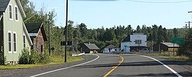
Ahmeek is a village in Keweenaw County in the U.S. state of Michigan. The village is located within Allouez Township. The population was 127 at the 2020 census.
The Keweenaw Peninsula is the northernmost part of Michigan's Upper Peninsula. It projects into Lake Superior and was the site of the first copper boom in the United States, leading to its moniker of "Copper Country." Its major industries are now logging and tourism, as well as jobs related to Michigan Technological University.
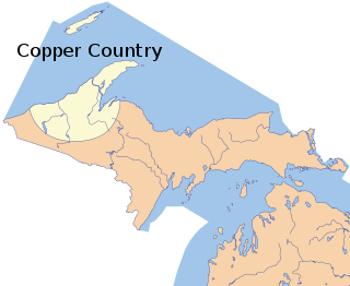
The Copper Country is an area in the Upper Peninsula of Michigan in the United States, including Keweenaw County, Michigan, Houghton, Baraga and Ontonagon counties as well as part of Marquette County. The area is so named as copper mining was prevalent there from 1845 until the late 1960s, with one mine continuing through 1995. In its heyday in the latter half of the 19th century and the early 20th century, the area was the world's greatest producer of copper.

M-26 is a 96.355-mile-long (155.068 km) state trunkline highway in the U.S. state of Michigan, running from two miles (3.2 km) east of Rockland to its junction with US Highway 41 (US 41) in Copper Harbor. It generally runs southwest-to-northeast in the western half or Michigan's Upper Peninsula. The northernmost segment, which closely parallels the shore of Lake Superior on the west side of the Keweenaw Peninsula, is highly scenic.

Copper Harbor is an unincorporated community and census-designated place (CDP) located in Keweenaw County in the U.S. state of Michigan. It is located within Grant Township. The population of the CDP was 136 as of the 2020 census.

Eagle Harbor is an unincorporated community and census-designated place located on the north side of the Keweenaw Peninsula within Eagle Harbor Township, Keweenaw County in the U.S. State of Michigan. Its population was 69 as of the 2020 census. M-26 passes through this community. This hamlet was especially popular with the sailors in days past, as it had a good steamboat landing and is about equally distant from Sault Sainte Marie, Michigan, and Duluth, Minnesota. It was the first stop for supplies for the many boats on Lake Superior.

The Keweenaw Waterway is a partly natural, partly artificial waterway which cuts across the Keweenaw Peninsula of Michigan; it separates Copper Island from the mainland. Parts of the waterway are variously known as the Keweenaw Waterway, Portage Canal, Portage Lake Canal, Portage River, Lily Pond, Torch Lake, and Portage Lake. The waterway connects to Lake Superior at its north and south entries, with sections known as Portage Lake and Torch Lake in between. The primary tributary to Portage Lake is the Sturgeon River.
Eagle River is an unincorporated community and census-designated place (CDP) in the U.S. state of Michigan. It is the county seat of Keweenaw County. Its population was 65 at the 2020 census, which makes it by far the least-populated county seat in the state of Michigan. As an unincorporated community, Eagle River has no legal autonomy and is part of Allouez Township and Houghton Township.

Gay is an unincorporated community in Keweenaw County in the U.S. state of Michigan. It is 12 miles from Lake Linden on Copper Island at the western end of the Upper Peninsula. As an unincorporated community, Gay has no legally recognized boundaries or population statistics of its own. Local government is provided by Sherman Township.
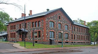
Keweenaw National Historical Park is a unit of the U.S. National Park Service. Established in 1992, the park celebrates the life and history of the Keweenaw Peninsula in the Upper Peninsula of the U.S. state of Michigan. As of 2009, it is a partly privatized park made up of two primary units, the Calumet Unit and the Quincy Unit, and 21 cooperating "Heritage Sites" located on federal, state, and privately owned land in and around the Keweenaw Peninsula. The National Park Service owns approximately 1,700 acres (690 ha) in the Calumet and Quincy Units. Units are located in Baraga, Houghton, Keweenaw, and Ontonagon counties.

The following is a list of Registered Historic Places in Keweenaw County, Michigan.
This National Park Service list is complete through NPS recent listings posted July 28, 2023.

Fort Wilkins Historic State Park is a historical park operated by the Michigan Department of Natural Resources at Copper Harbor, Michigan. The park preserves the restored 1844 army military outpost, Fort Wilkins, which was placed on the National Register of Historic Places in 1970. The state park's 700 acres (280 ha) include camping and day-use facilities as well as the Copper Harbor Lighthouse, built in 1866. The park is a "Cooperating Site" of the Keweenaw National Historical Park.

Lac La Belle is a small unincorporated community in Keweenaw County in the U.S. state of Michigan. The town was originally the site of a stamping plant for the copper mines of the Keweenaw, specifically the Mendota Mine and the Delaware Mine. Copper-bearing rock was transported from the mines to the stamping plant, where it was processed and loaded onto freighters.

In Michigan, copper mining became an important industry in the 19th and early 20th centuries. Its rise marked the start of copper mining as a major industry in the United States.

The Calumet and Hecla Industrial District is a historic district located in Calumet, Michigan and roughly bounded by Hecla & Torch Lake Railroad tracks, Calumet Avenue, Mine and Depot Streets. The district contains structures associated with the copper mines worked by the Calumet and Hecla Mining Company, located along a line above the copper lode, where railroad tracks connected separate mine heads. The Historic District is completely contained in the Calumet Historic District and the Keweenaw National Historical Park. It was designated a Michigan State Historic Site in 1973 and was listed on the National Register of Historic Places in 1974.
Winona, Michigan is an unincorporated community, ghost town and one-time boomtown of Elm River Township in Houghton County, Michigan. It was once home to over 1,000 individuals in 1920, but today is home to as few as 13. It is located 33 miles to the south of the city of Houghton off of M-26. In its heyday, Winona had restaurants, a brewery, sports teams, churches, boarding houses, a train depot, a saloon, stores, boardwalks, a school, five neighbourhoods, a dance hall and a barber shop. Only a school, a church, and a few homes remain intact.