
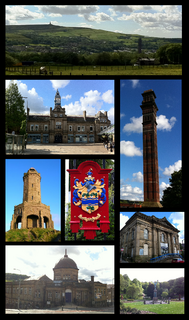
Blackburn is a large industrial town located in the Blackburn with Darwen borough in Lancashire, England. The town is north of the West Pennine Moors on the southern edge of the Ribble Valley, 8 mi (13 km) east of Preston and 21 mi (34 km) north-northwest of Manchester. Blackburn is the administrative centre of the Blackburn with Darwen unitary authority with the neighbouring town of Darwen.
Darwen is a market town and civil parish in the Blackburn with Darwen borough in Lancashire, England. The residents of the town are known as "Darreners". The A666 road passes through Darwen towards Blackburn to the north, Bolton to the south and Pendlebury where it joins the A6, about 18 miles (29 km) north-west of Manchester. The population of Darwen decreased to 28,046 in the 2011 census. The town comprises five wards and has its own town council.

Darwen Football Club is a football club from Darwen, Lancashire, England. The club was formed in 2009 as A.F.C. Darwen, a successor to the original Darwen club, which had been wound up. They currently play in the North West Counties League Division One North and are based at the Anchor Ground.

Oswaldtwistle is a town in the Hyndburn borough of Lancashire, England, 3 miles (5 km) southeast of Blackburn, contiguous with Accrington and Church. The town has a rich industrial heritage, being home to James Hargreaves, inventor of the spinning jenny and Sir Robert Peel of calico printing fame. The Leeds and Liverpool Canal passes through the town and was responsible for the export of much of the area's cotton produce.

Rossendale and Darwen is a constituency represented in the House of Commons of the UK Parliament since 2010 by Jake Berry, a Conservative.

The Bee was a local radio station serving southern and eastern parts of Lancashire, England. On Friday 27 May 2016, The Bee merged with its sister Lancashire station 2BR.

Rishton is a town in the Hyndburn district of Lancashire, England, about 2 miles (3 km) west of Clayton-le-Moors and 4 miles (6 km) north east of Blackburn. It was an urban district from about 1894 to 1974. The population at the census of 2011 was 6,625.

The River Calder is a major tributary of the River Ribble in Lancashire, England and is around 20 miles (32 km) in length.
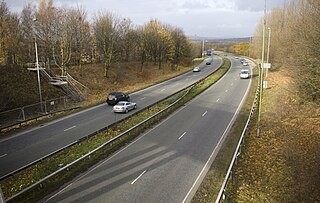
The A666 is a major road in Greater Manchester and Lancashire, England. Known as Manchester Road, Bolton Road, or Blackburn Road, depending on which area it is in, it runs from its junction with the A6, M61 and A580 at the Irlams o' th' Height boundary with Pendlebury near Manchester, through Pendlebury, Clifton, Kearsley, Farnworth, Bolton, Darwen and Blackburn before meeting the A59 at Langho. Along the route are the West Pennine Moors, the Turton and Entwistle reservoir and the Entwistle reservoir forest.

The River Laneshaw is a river in Northern England. It runs for 1.9 miles (3 km) from Laneshaw Reservoir to Laneshaw Bridge alongside the A6068 road and has a catchment area of 5.1 square miles (13.2 km2).

Livesey is a civil parish in the unitary borough of Blackburn with Darwen, in the ceremonial county of Lancashire, England. The population of the civil parish at the 2011 census was 6,202.
Radio Rovers is the official radio station of the English Championship football side Blackburn Rovers FC. It was launched at Ewood Park on 30 October 1993 and was the first dedicated football club radio station in the United Kingdom.

Blackamoor is one village in Lancashire, England which is to the south of Blackburn.

Bashall Brook is a minor river in Lancashire, England. It is 7.09 miles (11.41 km) long and has a catchment area of 6.86 square miles (1,777.68 ha).

Yate and Pickup Bank is a civil parish in the borough of Blackburn with Darwen, Lancashire, England. The population of the civil parish taken at the census of 2011 was 366. The parish contains two hamlets, Bank Fold and Pickup Bank and part of the village of Belthorn which is on the boundary with Hyndburn. It has boundaries with the parishes of Eccleshill to the west and North Turton to the south.
Darwen Football Club was an association football club from Darwen in Lancashire, North West England. The team, formed in 1870, was an early pioneer of professional football in Northern England, reaching the semi-finals of the 1880–81 FA Cup. They were a Football League member from 1891 to 1899. Darwen joined the Lancashire League in 1900 and remained in regional football afterwards. They last played in the First Division of the North West Counties Football League in 2008–09, when the club was wound-up. A successor team, A.F.C. Darwen, was founded soon after. Darwen played their home games at the Anchor Ground.
The Limy Water is a minor river in Lancashire, England. It is 4.95 miles (7.96 km) long and has a catchment area of 7.71 square miles (1,996.33 ha).

The Burnley Coalfield is the most northerly portion of the Lancashire Coalfield. Surrounding Burnley, Nelson, Blackburn and Accrington, it is separated from the larger southern part by an area of Millstone Grit that forms the Rossendale anticline. Occupying a syncline, it stretches from Blackburn past Colne to the Yorkshire border where its eastern flank is the Pennine anticline.
Partick Football Club was a football club based in the burgh of Partick, Scotland. The club was founded in 1875 and played their home games at Inchview on Dumbarton Road in the Whiteinch neighbourhood until they went defunct in 1885.
Blackburn power stations are a series of electricity generating stations that have provided electric power to the town of Blackburn and the wider area from 1895 to the present. The first station in Jubilee Street, Blackburn began operating in 1895. A new larger station known as Blackburn East or Whitebirk power station was commissioned in 1921 and was rebuilt in stages over the period 1942 to 1955. Whitebirk station closed in 1976. The 60 MW Blackburn Mill Combined Cycle Gas Turbine (CCGT) power station has generated electricity since 2002. The Blackburn energy from waste (EfW) plant is currently (2020) being planned.
