Earthquake scenario is a planning tool to determine the appropriate emergency responses or building systems in areas exposed to earthquake hazards. It uses the basics of seismic hazard studies, but usually places a set earthquake on a specific fault, most likely near a high-population area. Most scenarios relate directly to urban seismic risk, and seismic risk in general.
Some earthquake scenarios follow some of the latest methodologies from the nuclear industry, namely a Seismic Margin Assessment (SMA).[1] In the process, a Review Level Earthquake (RLE) is chosen that challenges the system, has a reasonable probability, and is not totally overwhelming.
Scenarios have been developed for Seattle,[2] New York City,[3] and many of the faults in California. In general, areas west of the Rockies use urban earthquakes of M7 (moment magnitude), and eastern cities use an M6.
Reasonable RLE for Toronto area
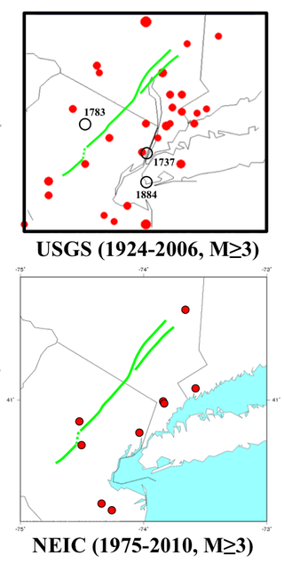
Some eastern cities do not have an earthquake scenario. As an example, the Greater Toronto area in Ontario, Canada has a local seismicity[4] with about as much a chance for an M6 as most of the moderate earthquake zones of Eastern North America (ENA), including New York City. As seen on the map, the RLE would be an M6 located in the western end of Lake Ontario. It could be suspected that the damage would follow the New York City scenario, with extensive damage to lifelines, and brick buildings on soft ground[citation needed].
An earthquake – also called a quake, tremor, or temblor – is the shaking of the Earth's surface resulting from a sudden release of energy in the lithosphere that creates seismic waves. Earthquakes can range in intensity, from those so weak they cannot be felt, to those violent enough to propel objects and people into the air, damage critical infrastructure, and wreak destruction across entire cities. The seismic activity of an area is the frequency, type, and size of earthquakes experienced over a particular time. The seismicity at a particular location in the Earth is the average rate of seismic energy release per unit volume.
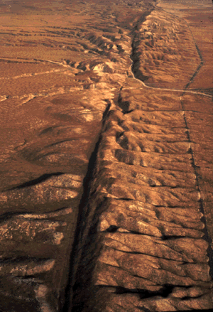
The San Andreas Fault is a continental right-lateral strike-slip transform fault that extends roughly 1,200 kilometers (750 mi) through the U.S. state of California. It forms part of the tectonic boundary between the Pacific Plate and the North American Plate. Traditionally, for scientific purposes, the fault has been classified into three main segments, each with different characteristics and a different degree of earthquake risk. The average slip rate along the entire fault ranges from 20 to 35 mm per year.
The epicenter, epicentre, or epicentrum in seismology is the point on the Earth's surface directly above a hypocenter or focus, the point where an earthquake or an underground explosion originates.
An intraplate earthquake is an earthquake that occurs in the interior of a tectonic plate, in contrast to an interplate earthquake on the boundary of a tectonic plate. It is also called an intraslab earthquake, especially when occurring in a microplate.
A seismic hazard is the probability that an earthquake will occur in a given geographic area, within a given window of time, and with ground motion intensity exceeding a given threshold. With a hazard thus estimated, risk can be assessed and included in such areas as building codes for standard buildings, designing larger buildings and infrastructure projects, land use planning and determining insurance rates. The seismic hazard studies also may generate two standard measures of anticipated ground motion, both confusingly abbreviated MCE; the simpler probabilistic Maximum Considered Earthquake, used in standard building codes, and the more detailed and deterministic Maximum Credible Earthquake incorporated in the design of larger buildings and civil infrastructure like dams or bridges. It is important to clarify which MCE is being discussed.
Seismic risk or earthquake risk is the potential impact on the built environment and on people's well-being due to future earthquakes. Seismic risk has been defined, for most management purposes, as the potential economic, social and environmental consequences of hazardous events that may occur in a specified period of time. A building located in a region of high seismic hazard is at lower risk if it is built to sound seismic engineering principles. On the other hand, a building located in a region with a history of minor seismicity, in a brick building located on fill subject to liquefaction can be as high or higher risk.
Urban seismic risk is the risk of earthquakes damaging or destroying people and things in towns and cities. Even if a big earthquake is likely urban seismic risk can be minimized with good earthquake construction, and seismic analysis. One of the best ways to deal with the issue is through an earthquake scenario analysis. Earthquake engineering can reduce the risk.
The New Madrid seismic zone (NMSZ), sometimes called the New Madrid fault line, is a major seismic zone and a prolific source of intraplate earthquakes in the Southern and Midwestern United States, stretching to the southwest from New Madrid, Missouri.
An active fault is a fault that is likely to become the source of another earthquake sometime in the future. Geologists commonly consider faults to be active if there has been movement observed or evidence of seismic activity during the last 10,000 years.
The Hayward Fault Zone is a right-lateral strike-slip geologic fault zone capable of generating destructive earthquakes. The fault was first named in the Lawson Report of the 1906 San Francisco Earthquake in recognition of its involvement in the earthquake of 1868. This fault is about 119 km (74 mi) long, situated mainly along the western base of the hills on the east side of San Francisco Bay. It runs through densely populated areas, including Richmond, El Cerrito, Berkeley, Oakland, San Leandro, Castro Valley, Hayward, Union City, Fremont, and San Jose.
Induced seismicity is typically earthquakes and tremors that are caused by human activity that alters the stresses and strains on Earth's crust. Most induced seismicity is of a low magnitude. A few sites regularly have larger quakes, such as The Geysers geothermal plant in California which averaged two M4 events and 15 M3 events every year from 2004 to 2009. The Human-Induced Earthquake Database (HiQuake) documents all reported cases of induced seismicity proposed on scientific grounds and is the most complete compilation of its kind.
The Fukuoka earthquake, also known as the Fukuoka Prefecture West Sea Earthquake, struck Fukuoka Prefecture, Japan at 10:53 am JST on March 20, 2005, off the northwest coast of Fukuoka Prefecture, and lasted for approximately 1 minute. The Japan Meteorological Agency (JMA) measured it as peaking at a magnitude of 7.0 and a maximum seismic intensity of less than six, whereas the United States Geological Survey (USGS) reported a magnitude of 6.6. The quake occurred along a previously unknown fault in the Genkai Sea, North of Fukuoka city, and the residents of Genkai Island were forced to evacuate as houses collapsed and multiple landslides occurred in various places. Investigations subsequent to the earthquake determined that the new fault was most likely an extension of the known Kego fault that runs through the centre of the city.
The 2003 San Simeon earthquake struck at 11:15 PST on December 22 on the Central Coast of California, about 7 miles (11 km) northeast of San Simeon. Probably centered in the Oceanic fault zone within the Santa Lucia Mountains, it was caused by thrust faulting and the rupture propagated southeast from the hypocenter for 12 miles (19 km).
The 2004 Al Hoceima earthquake occurred on 24 February at 02:27:47 local time near the coast of northern Morocco. The strike-slip earthquake measured 6.3 on the moment magnitude scale and had a maximum perceived intensity of IX (Violent) on the Mercalli intensity scale. Between 628 and 631 people were killed, 926 injured, and up to 15,000 people were rendered homeless in the Al Hoceima-Imzourene-Beni Abdallah area.
At 05:12 AM Pacific Standard Time on Wednesday, April 18, 1906, the coast of Northern California was struck by a major earthquake with an estimated moment magnitude of 7.9 and a maximum Mercalli intensity of XI (Extreme). High-intensity shaking was felt from Eureka on the North Coast to the Salinas Valley, an agricultural region to the south of the San Francisco Bay Area. Devastating fires soon broke out in San Francisco and lasted for several days. More than 3,000 people died, and over 80% of the city was destroyed. The event is remembered as the deadliest earthquake in the history of the United States. The death toll remains the greatest loss of life from a natural disaster in California's history and high on the lists of American disasters.
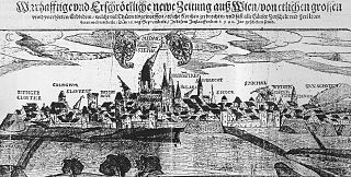
The Neulengbach earthquake of 1590 occurred on 15 September shortly before midnight amidst a long series of much weaker seismic activity starting on 29 June and with aftershocks reported until 12 November. It was the strongest historically documented earthquake in what today is Northeastern Austria.
The Ramapo Fault zone is a system of faults between the northern Appalachian Mountains and Piedmont areas to the east. Spanning more than 185 miles (298 km) in New York, New Jersey, and Pennsylvania, it is perhaps the best known fault zone in the Mid-Atlantic region, and some small earthquakes have been known to occur in its vicinity. Recently, public knowledge about the fault has increased, especially after the 1970s, when the fault's proximity to the Indian Point nuclear plant in New York was noted.
The 1916 Irondale earthquake struck in the north–central region of the U.S. state of Alabama on October 18. The strongest earthquake in state history, it registered an estimated Richter scale magnitude of 5.1 and resulted in minor damage. Damage was limited to Shelby and Jefferson counties and reached its maximum severity near the epicenter in the city of Irondale, including cracked windows, fallen chimneys, and dried-up wells. While there were no fatalities, the earthquake spawned widespread panic, prompting alarmed workers to evacuate tall buildings.
The 1303 Crete earthquake occurred at about dawn on 8 August. It had an estimated magnitude of about 8, a maximum intensity of IX (Violent) on the Mercalli intensity scale, and triggered a major tsunami that caused severe damage and loss of life on Crete and at Alexandria. It badly damaged the Lighthouse of Alexandria.
Seismicity of the New York City area is relatively low. New York is less seismically active than California because it is far from any plate boundaries. Large and damaging intraplate earthquakes are relatively rare. When they do occur in the Northeastern United States, the areas affected by them are much larger than for earthquakes of similar magnitude on the West Coast of the United States. The largest known earthquake in the greater New York City area occurred in 1884, probably somewhere between Brooklyn and Sandy Hook, and had a magnitude of approximately 5. The New York quakes in 2023 and 2024 were shallow quakes.
This page is based on this Wikipedia article Text is available under the CC BY-SA 4.0 license; additional terms may apply. Images, videos and audio are available under their respective licenses.