
The Eask Tower is a solid stone tower on the top of Carhoo Hill, in County Kerry, Ireland, overlooking Dingle harbour. [1]
The Eask Tower is a solid stone tower on the top of Carhoo Hill, in County Kerry, Ireland, overlooking Dingle harbour. [1]
Eask Tower was built in 1847 in order to guide the ships and boats into the mouth of the harbour. The wooden hand pointing from the Tower guides the boats to their destination. It is crowned with the 19th century's mariners beacon and a World War II look-out post. [2] The harbour has a "blind" mouth, so the purpose of the tower is to advise the ships to retract their sails, lose speed and thus safely sail around the harbour mouth. [1]
The tower is of solid stone. The building of it on Carhoo (Ceathru) hill, 180 metres (600 ft) above sea level, provided work during the Great Famine, at the instigation of Reverend Charles Gayer, leader of the Protestants, in an attempt to win converts. The tower was originally 8.2 metres (27 ft) high, but around the year 1900, the old hand was removed and an extra 4.0 metres (13 ft) of stone was added to its height. A new hand was placed, roughly at the beginning of the extension. [3]
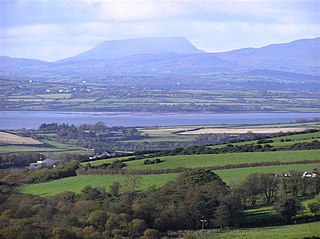
The panoramic views seen from Carhoo Hill include a large proportion of the Dingle Peninsula and beyond; for example, the Blasket Islands, Slea Head, Ventry, Dingle Harbour, the Iveragh Peninsula, Skellig Rocks, and two of Ireland's highest mountains - Carrauntoohil and Mount Brandon.

Poole Harbour is a large natural harbour in Dorset, southern England, with the town of Poole on its shores. The harbour is a drowned valley (ria) formed at the end of the last ice age and is the estuary of several rivers, the largest being the Frome. The harbour has a long history of human settlement stretching to pre-Roman times. The harbour is extremely shallow, with one main dredged channel through the harbour, from the mouth to Holes Bay.
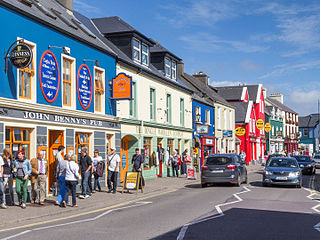
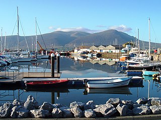
Dingle is a town in County Kerry, Ireland. The only town on the Dingle Peninsula, it sits on the Atlantic coast, about 50 kilometres (30 mi) southwest of Tralee and 71 kilometres (40 mi) northwest of Killarney.

The Gallarus Oratory (Irish: Séipéilín Ghallarais, Gallarus being interpreted as either 'rocky headland' or 'house or shelter for foreigner ' is a chapel on the Dingle Peninsula, County Kerry, Ireland. It has been presented variously as an early-Christian stone church by antiquary Charles Smith, in 1756; a 12th century Romanesque church by archaeologist Peter Harbison in 1970; a shelter for pilgrims by the same in 1994. The local tradition prevalent at the time of Charles Smith attributed it to one Griffith More, being a funerary chapel built by him or his family at their burial place.
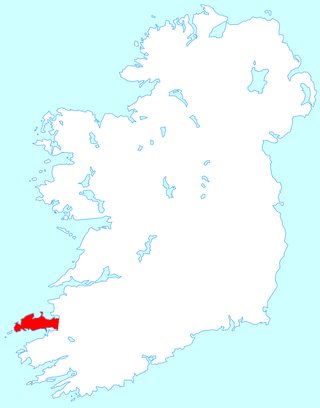
The Dingle Peninsula is the northernmost of the major peninsulas in County Kerry. It ends beyond the town of Dingle at Dunmore Head, the westernmost point of Ireland and arguably Europe.

The Rhins of Galloway, otherwise known as the Rhins of Wigtownshire, is a hammer-head peninsula in Dumfries and Galloway, Scotland. Stretching more than 25 miles from north to south, its southern tip is the Mull of Galloway, the southernmost point of Scotland.
Lough Swilly in Ireland is a glacial fjord or sea inlet lying between the western side of the Inishowen Peninsula and the Fanad Peninsula, in County Donegal. Along with Carlingford Lough and Killary Harbour it is one of three glacial fjords in Ireland.

Mount Brandon or Brandon, at 952 metres (3,123 ft), is one of the ten highest peaks in Ireland, being the 8th–highest peak in Ireland on the Arderin list, and the 9th–highest on the Vandeleur-Lynam list. Brandon is the highest Irish mountain outside the MacGillycuddy's Reeks range and has the greatest prominence of any Irish peak except Carrauntoohil, Ireland's highest mountain.

Beara or the Beara Peninsula is a peninsula on the south-west coast of Ireland, bounded between the Kenmare "river" to the north side and Bantry Bay to the south. It contains two mountain ranges running down its centre: the Caha Mountains and the Slieve Miskish Mountains. The northern part of the peninsula from Kenmare to near Ardgroom is in County Kerry, while the rest forms the barony of Bear in County Cork.

Ventry, officially Ceann Trá, is a Gaeltacht village in County Kerry, Ireland, on the Dingle Peninsula, 7 kilometres west of Dingle. Due to its long sandy beach, Ventry is a popular tourist destination. The town is connected to Dingle via the R559 regional road.
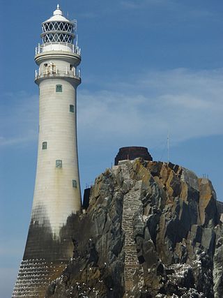
Fastnet Lighthouse is a 54-metre-tall (177 ft) lighthouse situated on the remote Fastnet Rock in the Atlantic Ocean. It is the most southerly point of Ireland and lies 6.5 kilometres (4.0 mi) southwest of Cape Clear Island and 13 kilometres (8.1 mi) from County Cork on the Irish mainland. The current lighthouse is the second to be built on the rock and is the tallest in Ireland.

Dingle Bay is a bay located in County Kerry, western Ireland. The outer parts of the Dingle Peninsula and Dingle Bay mark one of the westernmost points of mainland Ireland. The harbour town of Dingle lies on the north side of the bay.

Brandon Creek is a small village located on the Dingle Peninsula, Ireland.

Tralee Bay is located in on the west coast of County Kerry, Ireland. It is situated between Kerry Head on the north side and the Maharees on the west and extends eastwards as far as the bridge at Blennerville. Several small rivers feed into the bay through the town of Tralee. Villages around the bay include; Ballyheigue, Fenit, Kilfinora, Spa, Blennerville, Camp and Castlegregory.

Fisgard Lighthouse National Historic Site, on Fisgard Island at the mouth of Esquimalt Harbour in Colwood, British Columbia, is the site of Fisgard Lighthouse, the first lighthouse on the west coast of Canada.
Slieve Mish Mountains, is a predominantly sandstone mountain range at the eastern end of the Dingle Peninsula in County Kerry, Ireland. Stretching 19 kilometres, from the first major peak of Barnanageehy outside of Tralee in the east, to Cnoc na Stuaice in near Central Dingle in the west, the range has over 17 material peaks, with the core of the mountain range based around the massif of its highest peak, Baurtregaum, and its deep glacial valleys of Derrymore Glen and Curraheen Glen.

Caherconree at 835 metres (2,740 ft), is the 20th–highest peak in Ireland on the Arderin scale, and the 27th–highest peak on the Vandeleur-Lynam scale. Caherconree is the 2nd-highest mountain in the Slieve Mish Mountains in the Dingle Peninsula in Kerry, Ireland, and one of its southerly spurs is the site of an ancient stone promontory fort, which is a protected National Monument.

Completed in 1849, the original 20-metre (66 ft) Wadjemup Lighthouse was Western Australia's first stone lighthouse and was built to provide a safer sailing passage for ships to Fremantle Port and the Swan River Colony.

The Dingle Way is a long-distance trail around the Dingle Peninsula in County Kerry, Ireland. It is a 162-kilometre (101-mile) long circular route that begins and ends in Tralee and is typically completed in eight days. It is designated as a National Waymarked Trail by the National Trails Office of the Irish Sports Council and is managed by the Dingle Way Committee and Kerry County Council.
Rose Hill Packet, was a marine craft built in Australia to serve the second place of European settlement in Australia, "Rose Hill", the furthest navigable point inland on the Parramatta River. When launched the vessel was named Prince William but was later named the Rosehill Packet by the convicts. The boat design was later called a packet boat, because its use was that of running the first Parramatta River trade ferry, passenger, cargo, and mail service between the Sydney Cove and the Rose Hill (Parramatta) First Fleet settlements after she was launched in Sydney Cove in September and commissioned on 5 October 1789. She was the first purpose-built sailing vessel constructed in Australia. She later earned the nickname 'The Lump'. Some authorities believe that a 1790 drawing by First Fleet MIdshipman George Raper shows the vessel in the centre of Sydney Cove.

Carhoo Hill or Ballymacadoyle Hill is a large hill south-west of Dingle in County Kerry, Ireland.
Coordinates: 52°06′56″N10°16′52″W / 52.115539°N 10.28124°W