
Portland is the largest city in the U.S. state of Maine and the seat of Cumberland County. Portland's population was 68,408 in April 2020. The Greater Portland metropolitan area is home to over half a million people, the 104th-largest metropolitan area in the United States. Portland's economy relies mostly on the service sector and tourism. The Old Port is known for its nightlife and 19th-century architecture. Marine industry plays an important role in the city's economy, with an active waterfront that supports fishing and commercial shipping. The Port of Portland is the second-largest tonnage seaport in New England.

Dorchester is a Boston neighborhood comprising more than 6 square miles (16 km2) in the City of Boston, Massachusetts, United States. Originally, Dorchester was a separate town, founded by Puritans who emigrated in 1630 from Dorchester, Dorset, England, to the Massachusetts Bay Colony. This dissolved municipality, Boston's largest neighborhood by far, is often divided by city planners in order to create two planning areas roughly equivalent in size and population to other Boston neighborhoods.

Edward Payson Park is a 47.5-acre (19.2 ha) public park in the Back Cove neighborhood of Portland, Maine. The park is bordered by Ocean Avenue to the north and Baxter Boulevard to the south. The offices of the Roman Catholic Diocese of Portland are located across from the park on Ocean Avenue.

Deering Oaks is a 55-acre (22 ha) public park in Portland, Maine, which has a baseball diamond, tennis courts, a playground, and a pond. It is located west of downtown Portland and is bordered by Deering Avenue on the west, Forest Avenue on the east, Park Avenue to the south and Interstate 295 to the north. State Street bisects the park. Access is from State Street, Deering Avenue, or Park Avenue. The Portland Farmers Market is located on the Park Avenue side of the park. The park is listed on the National Register of Historic Places.
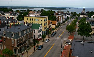
Munjoy Hill is a neighborhood and prominent geographical feature of Portland, Maine. It is located east of downtown and south of East Deering, the neighborhood it is connected to by Tukey's Bridge. The neighborhood historically had a large Irish and Italian American population.

Great Diamond Island is an island in Casco Bay, Maine, United States. It is part of the city of Portland, Maine. At the 2000 census, the island had a year-round population of 77. The island is not accessible from the mainland by motor vehicle and has a limited network of roads. The primary modes of transportation are golf carts and bicycles. This fact has become a selling point for the island, marketing the area as "car free" and "kid friendly". The island was used as a military base starting in the late 19th century and continuing through World War II. After the base was decommissioned, the bunkers and residences were left idle for over 30 years before being developed and sold to private citizens.
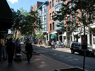
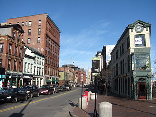
The Old Port is a district of Portland, Maine, known for its cobblestone streets, 19th-century brick buildings and fishing piers. The district is filled with boutiques, restaurants and bars. Because of its reputation for nightlife, the Old Port is a popular destination for tourists and locals alike.

The railroad history of Portland, Maine, began in 1842 with the arrival of the Portland, Saco & Portsmouth Railway (PS&P). Most of the rail activity in Portland revolved around agricultural goods bound for export and import freight from Europe. Yet Maine's largest city also enjoyed 125 years of continuous passenger rail service, from 1842 until 1967, and Amtrak began serving the city in 2001. For most of Portland's history, passenger train schedules were designed with intercity travel rather than daily commuting in mind; passenger activities were mostly confined to intercity travel from Portland to Boston, Montreal, Nova Scotia, and points west.

The Upper Eastside is a neighborhood in Miami, Florida. It is north of Edgewater, east of Little Haiti, south of the village of Miami Shores, and sits on Biscayne Bay. In geographical order from south to north and east to west, it contains the subdivisions of Magnolia Park, Bay Point, Morningside, Bayside, Belle Meade, Shorecrest, and Palm Grove. The MiMo District along Biscayne Boulevard in the area is host to many art galleries, shops and restaurants.

Brooklyn is one of the southernmost neighborhoods in Baltimore, Maryland. It is located near Anne Arundel County along Governor Ritchie Highway which is also Maryland Route 2. Its main roads are South Hanover Street,, Potee Street, and East Patapsco Avenue, Sixth Street, Tenth Street, and West Bay Avenue which borders the neighboring Curtis Bay community to the east, running through Bay Brook Park, which separates the two. South Hanover Street also serves as the dividing line between east–west streets in Brooklyn, as Charles Street does not exist here. Often mistaken as Brooklyn Park, Brooklyn shares the 21225 ZIP Code with the greater Brooklyn Park area which is across the Baltimore City Line in and the other neighboring community of Cherry Hill to the west and northwest across the now small western branch of the Patapsco River flowing from Ellicott City and Elkridge and along the shoreline-hugging southern extension "South Hanover Street" of the downtown's old colonial-era "Hanover Street" across the 1914-1917 Hanover Street Bridge, later renamed the Vietnam Veterans Memorial Bridge in the 1990s.
Kennedy Park is a neighborhood in East Bayside in downtown Portland, Maine, built around a park, athletic fields, basketball courts, a playground and the Boyd Street Urban Garden.
The West End is a downtown neighborhood in Portland, Maine. It is located on the western side of Portland's peninsula primarily on Bramhall Hill and is noted for its architecture and history. The neighborhood is home to many late 19th- and early 20th-century homes and, in 2010, it was called "one of the best preserved Victorian neighborhoods in the country". The Western Promenade, a park laid out in 1836, overlooks the forests and small settlements of Southwestern Maine, along with the distant White Mountains. Other historic structures include 68 High Street, The Gothic House, Brown House, Butler House, Ingraham House, Morrill Mansion and the Minott House.
Herbert C. Adams is an American historian, politician, and journalist from Maine. A Democrat, Adams was a member of the Portland School Committee from 1997–2004. He represented the Portland neighborhoods of East Bayside and Parkside in the Maine House of Representatives. He is also a noted historian of local history, having published Bold Vision: the History of the Portland Park System in 2000.
Portland, Maine, is home to many neighborhoods.
Monument Square is a town square located in downtown Portland, Maine, about halfway between the East Bayside and Old Port neighorhoods. The Time and Temperature Building, Fidelity Trust Building, and the main branch of the Portland Public Library are on Congress Street across from the square, while One Monument Square and One City Center are among a number of buildings located on the square.

Franklin Street is a four-lane street in Portland, Maine, with a controversial history. It began as Essex Street in the 18th century, but changed to Franklin Street by 1823. It is a major corridor for traffic from Interstate 295 to Portland's downtown, Old Port, and to other neighborhoods located on the Portland peninsula.
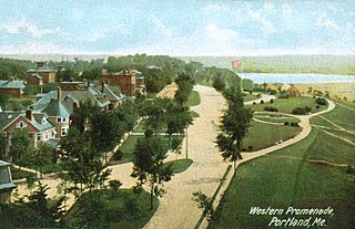
The Western Promenade is a historic promenade, an 18.1-acre (7.3 ha) public park and recreation area in the West End neighborhood of Portland, Maine. Developed between 1836 and the early 20th century, it is one Portland's oldest preserved spaces, with landscaping by the Olmsted Brothers, who included it in their master plan for the city's parks. The promenade was listed on the National Register of Historic Places in 1989.
Congress Street is the main street in Portland, Maine. Congress stretches from Portland's southwestern border with Westbrook through a number of neighborhoods before ending overlooking the Eastern Promenade on Munjoy Hill. In March 2009, the Portland City Council designated much of the inner portion of Congress Street an historic district. The western section of the street includes the city's Arts District.
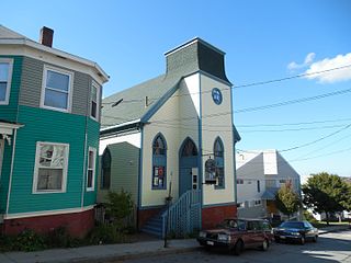
Mayo Street Arts is a community arts and performance venue in the East Bayside neighborhood of Portland, Maine. It was founded in 2010 by Blainor McGough after leasing the building which was formerly St. Ansgar Church. Mayo Street Arts' second executive director, Ian Bannon, succeeded McGough in May 2020 following McGough's resignation. Located next to Kennedy Park, a public housing development and close to many other public housing areas, Mayo Street Arts serves as a theater, concert venue, art gallery, and meeting space and offers affordable artist studios, rehearsal space, and a teaching platform for visual and performing artists of multicultural backgrounds. Programming is varied, but with a particular focus on puppetry, folk music, and dance.
