Fish Street (formerly) | |
![]() The foot of Exchange Street, viewed from Fore Street in 2024 | |
![]() | |
Length | 0.24 mi (0.39 km) |
---|---|
Location | Portland, Maine, U.S. |
Northwest end | Congress Street |
Southeast end | Fore Street |
Exchange Street is a main commercial thoroughfare in the Old Port of Portland, Maine, United States. Originally laid out in 1724, [1] today it features a number of designer clothing stores, as well as several small, locally owned businesses, [2] including Sherman's Maine Coast Books. It runs, one-way, for around 0.24 miles (0.39 km), from Congress Street in the northwest to Fore Street in the southeast. Its main intersections are with (from northwest to southeast) Congress Street, Federal Street, Middle Street and Fore Street.
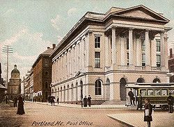
The Merchant Exchange Building, which formerly stood in Post Office Park between Middle Street, Market Street and Exchange Street, [3] was the home of Atlantic Bank. [4] Completed in 1839, to designs by Boston architect Richard Bond, it was an attempt by local businessmen to return the state government to Portland from Augusta. After being used as a U.S. Custom House into the 1850s, it burned down in 1854. Two more federal buildings stood at the location between 1854 and 1965. [5]
Built 1866, the John Neal Block stands at 16 Exchange Street. [6] John Neal first established his law practice on Exchange Street in 1827, [7] located next door to the law office of Samuel Fessenden. [8]
Before the 1970s, Exchange Street and the Old Port area had become largely run-down and deserted. Gentrification began in the early 1970s and continues to this day.
Historically, Exchange Street was where many printers (such as The Anthoensen Press) and newspapers were located. At the top of Exchange Street, strategically located across Congress Street from Portland City Hall, is the Press Herald Building built in 1923 and expanded in 1948 as the headquarters of the Portland Press Herald. In 2015, the renovated building became the Press Hotel. [9]
Exchange Street was known as Fish Street until around 1810. In 1837, Court Street, which ran between Federal Street and Congress Street, became part of Exchange Street. [4]
Tommy's Park stands at the northwestern corner of Exchange Street's intersection with Middle Street, while Post Office Park is at the northeastern corner.
Portland is the most populous city in the U.S. state of Maine and the county seat of Cumberland County. Portland's population was 68,408 in April 2020. The Greater Portland metropolitan area has a population of approximately 550,000 people. Historically tied to commercial shipping, the marine economy, and light industry, Portland's economy in the 21st century relies mostly on the service sector. The Port of Portland is the second-largest tonnage seaport in the New England area as of 2019.
Munjoy Hill is a neighborhood and prominent geographical feature of Portland, Maine. It is located east of downtown and south of East Deering. In the nineteenth and twentieth centuries, the neighborhood had a large Irish and Italian American population.
Portland Public Library is the main library of the public library system in Portland, Maine, USA. It is located at 5 Monument Square on Congress Street in the Old Port of Portland, Maine. The library has three neighborhood branches, Burbank branch, Peaks Island branch, and Riverton branch.
The Old Port is a district of Portland, Maine, known for its cobblestone streets, 19th-century brick buildings and fishing piers. The district contains boutiques, restaurants and bars.
The Portland Company was established 10 November 1846 by John A. Poor and Norris Locomotive Works engineer Septimus Norris as a locomotive foundry to build railroad equipment for the adjacent Portland terminus of the Atlantic and St. Lawrence Railroad connection between Portland, Maine, and Montreal. The shops opened for business in October, 1847. Its first locomotive, the Augusta, emerged from the shops in July 1848 for delivery to the Portland, Saco & Portsmouth. Over the next several decades, the company produced in its Fore Street facilities over 600 steam locomotives as well as 160 merchant and naval vessels, railcars, construction equipment, Knox automobiles, and the like. Portland Company built the engines of the civil war side-wheel gunboats Agawam and Pontoosuc. Taking into account its other products, the company could lay claim to being one of the leading medium-to-heavy steel manufacturers in New England. The company ceased production in 1978.
The History of Portland, Maine, begins when Native Americans originally called the Portland peninsula Məkíhkanək meaning "At the fish hook" in Penobscot and Machigonne in Algonquian. The peninsula and surrounding areas were home to members of the Algonquian-speaking Aucocisco branch of the Eastern Abenaki tribe, who died largely due to the introduction of foreign illnesses during colonization. Some were forcibly relocated to current day New Hampshire and Canada during European settlement.
Commercial Street is a downtown street in the Old Port of Portland, Maine, United States. It is part of U.S. Route 1A. It became the Old Port's waterfront in the early 20th century, replacing Fore Street, after land was reclaimed from the waters of Casco Bay and the Fore River.
Monument Square is a town square in downtown Portland, Maine, about halfway between the East Bayside and Old Port neighborhoods. One Monument Square and One City Center are among the buildings on the square itself, while the Time and Temperature Building, Fidelity Trust Building and the main branch of the Portland Public Library are on Congress Street, across from the square.
Franklin Street is a four-lane street in Portland, Maine, United States. It is a major corridor for traffic from Interstate 295 to Portland's downtown, Old Port, and to other neighborhoods located on the Portland peninsula. Part of U.S. Route 1A, it is around 0.77 miles (1.24 km) long, running between Marginal Way in the northwest and Commercial Street in the southeast.
Congress Street is the main street in Portland, Maine. Around 5.77 miles (9.29 km) long, it stretches from County Road, Portland's southwestern border with Westbrook, through a number of neighborhoods, before ending overlooking the Eastern Promenade on Munjoy Hill. In March 2009, the Portland City Council designated much of the inner portion of Congress Street a historic district. The western section of the street includes the city's Arts District.
The following is a timeline of the history of the city of Portland, Maine, USA.
Chandler's Wharf is a historic wharf in Portland, Maine, on the edge of the Fore River. It stands across Commercial Street from Dana Street and, on the waterfront side, between Long Wharf and Widgery Wharf.
George Munjoy was an early settler in what was Falmouth, Province of Maine. Munjoy Hill, in today's Portland, Maine, is named for him, as was Peaks Island for a period.
Fore Street is a downtown street in Portland, Maine, United States. Dating to 1724, it runs for around 1 mile (1.6 km), from the Eastern Promenade on Munjoy Hill in the northeast to Pleasant Street in the southwest. Near its midsection, Fore Street crosses Franklin Street. It splits briefly at Boothby Square, shortly after passing the United States Custom House. The street passes through the Old Port district.
Woodfords Corner is a neighborhood and major intersection in Portland, Maine, United States. Centered around the intersections of Forest Avenue and Woodford Street, it is named for brothers Chauncey, Ebenezer and Isaiah Woodford, merchants from Connecticut who settled in the area.
Middle Street is a downtown street in Portland, Maine, United States. Dating to 1724, it runs for around 0.46 miles (0.74 km), from an intersection with Union Street, Spring Street and Temple Street in the southwest, to Hancock Street, at the foot of Munjoy Hill, in the northeast. It formerly originated at what was then known as Market Square, but 20th-century redevelopment saw the section between Monument Square and Free Street pedestrianized, and the remaining section—around The Maine Lobsterman monument on Temple Street—erased.
India Street is a downtown street and neighborhood in Portland, Maine, United States. Situated near the western foot of Munjoy Hill, it runs for around 0.28 miles (0.45 km), from Congress Street in the northwest to Commercial Street and Thames Street in the southeast. It was the city's first street, and the location of the first settlement of European immigrants to the city in the 17th century. There are thirty handmade bricks in the sidewalk commemorating the neighborhood's notable events. In 1680, when Thomas Danforth was Deputy Governor of the Massachusetts Bay Colony, the street was known as Broad Street. After the incorporation of the Town of Falmouth in 1718, the street was known as High King Street.
Moulton Street is a historic downtown street in Portland, Maine, United States. Situated in the heart of the Old Port, it runs for around 233 feet (71 m), from Fore Street in the northwest to Commercial Street in the southeast. One-way from Fore Street, its surface is cobblestoned, with brick sidewalks. The street is named for William H. Moulton, president of the Cumberland Bank, which stood at the corner of Moulton and Commercial.
Federal Street is a historic downtown street in Portland, Maine, United States. It runs for around 0.56 miles (0.90 km), from Monument Square, in the southwest to Mountfort Street, at the foot of Munjoy Hill, in the northeast. Its middle section was wiped out by the widening of Franklin Street in 1967.
St. John Street is a street in Portland, Maine, United States. It runs for around 1.34 miles (2.16 km) from Brighton Avenue, in the north, to Valley Street, in the south. It crosses Park Avenue and Congress Street and passes beneath Interstate 295.
{{cite web}}
: CS1 maint: numeric names: authors list (link)