Related Research Articles

Portland is the most populous city in the U.S. state of Maine and the seat of Cumberland County. Portland's population was 68,408 in April 2020. The Greater Portland metropolitan area has a population of approximately 550,000 people. Historically tied to commercial shipping, the marine economy, and light industry, Portland's economy in the 21st century relies mostly on the service sector. The Port of Portland is the second-largest tonnage seaport in the New England area as of 2019.

Lewiston is the second most populous city in the U.S. state of Maine, with the city's population at 37,121 as of the 2020 United States Census. The city lies halfway between Augusta, the state's capital, and Portland, the state's most populous city. A part of Androscoggin County, it is one-half of the Lewiston–Auburn metropolitan statistical area, commonly referred to as "L/A." or "L-A." Lewiston exerts a significant impact upon the diversity, religious variety, commerce, education, and economic power of Maine. It is known for having an overall low cost of living, substantial access to medical care, and a low violent-crime rate. In recent years, the city of Lewiston has also seen a spike in economic and social growth. While the dominant language spoken in the city is English, it is home to a significant Somali population as well as the largest French-speaking population in the United States while it is second to St. Martin Parish, Louisiana, in percentage of speakers.

South Portland is a city in Cumberland County, Maine, United States, and is the fourth-most populous city in the state, incorporated in 1898. At the 2020 census, the city population was 26,498. Known for its working waterfront, South Portland is situated on Portland Harbor and overlooks the skyline of Portland and the islands of Casco Bay. Due to South Portland's close proximity to air, marine, rail, and highway transportation options, the city has become a center for retail and industry in the region. The Maine Mall, the largest shopping mall in the state, is located in South Portland. It is also a designated Tree City USA community.

Urban renewal is a program of land redevelopment often used to address urban decay in cities. Urban renewal involves the clearing out of blighted areas in inner cities in favour of new housing, businesses, and other developments.

Dorchester is a neighborhood comprising more than 6 square miles (16 km2) in the City of Boston, Massachusetts, United States. Originally, Dorchester was a separate town, founded by Puritans who emigrated in 1630 from Dorchester, Dorset, England, to the Massachusetts Bay Colony. This dissolved municipality, Boston's largest neighborhood by far, is often divided by city planners in order to create two planning areas roughly equivalent in size and population to other Boston neighborhoods.

James J. Fitzpatrick Stadium is a 6,300-seat multi-purpose outdoor stadium in Portland, Maine, United States. Built in 1930, it sits between Interstate 295, Hadlock Field baseball stadium, King Middle School, and the Portland Exposition Building. It is located across Deering Avenue from Deering Oaks Park. It was renamed in 1989 to honor James J. Fitzpatrick, one of the most respected figures in Maine athletic history.
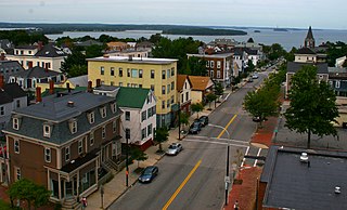
Munjoy Hill is a neighborhood and prominent geographical feature of Portland, Maine. It is located east of downtown and south of East Deering, the neighborhood via Tukey's Bridge. In the nineteenth and twentieth centuries, the neighborhood had a large Irish and Italian American population.
Manhattantown, now known as Park West Village or West Park Apartments, was a massive urban renewal project in New York City's Manhattan Valley neighborhood. The project, which stretched between West 96th and West 100th streets, bordering Central Park West, was funded by Title I of the Housing Act of 1949, which financed slum clearance under urban redevelopment initiatives. Allegations of corruption were leveled soon after the project's inception in the spring of 1949, culminating in hearings in the Senate's Banking and Currency Committee in 1954.

The Old Port is a district of Portland, Maine, known for its cobblestone streets, 19th-century brick buildings and fishing piers. The district contains boutiques, restaurants and bars.

The American Housing Act of 1949 was a landmark, sweeping expansion of the federal role in mortgage insurance and issuance and the construction of public housing. It was part of President Harry Truman's program of domestic legislation, the Fair Deal.

Columbia Point, in the Dorchester neighborhood of Boston, Massachusetts, sits on a peninsula jutting out from the mainland of eastern Dorchester into the bay. Old Harbor Park is on the north side, adjacent to Old Harbor, part of Dorchester Bay. The peninsula is primarily occupied by Harbor Point, the University of Massachusetts Boston, the John F. Kennedy Presidential Library and Museum, the Edward M. Kennedy Institute for the United States Senate, and a complex at the former Bayside Expo Center, Boston College High School, and the Massachusetts Archives. The Boston Harborwalk follows the entire coastline.

East Bayside is a neighborhood in Portland, Maine. It is bordered by Franklin Street on the west, Washington Avenue on the east, to the north by Marginal Way, and the south by Congress Street. It is bordered by the neighborhoods of Bayside, the Old Port and Munjoy Hill. It is often confused with the Bayside neighborhood, which is on the opposite side of Franklin Street.
Portland, Maine, is home to many neighborhoods.
Monument Square is a town square in downtown Portland, Maine, about halfway between the East Bayside and Old Port neighborhoods. One Monument Square and One City Center are among the buildings on the square itself, while the Time and Temperature Building, Fidelity Trust Building and the main branch of the Portland Public Library are on Congress Street, across from the square.

Franklin Street is a four-lane street in Portland, Maine, United States. It is a major corridor for traffic from Interstate 295 to Portland's downtown, Old Port, and to other neighborhoods located on the Portland peninsula. Part of U.S. Route 1A, it is around 0.77 miles (1.24 km) long, running between Marginal Way in the northwest and Commercial Street in the southeast.
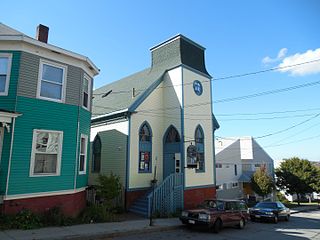
Mayo Street Arts is a community arts and performance venue in the East Bayside neighborhood of Portland, Maine. It was founded in 2010 by Blainor McGough after leasing the building which was formerly St. Ansgar Church. Mayo Street Arts' second executive director, Ian Bannon, succeeded McGough in May 2020 following McGough's resignation. Located next to Kennedy Park, a public housing development and close to many other public housing areas, Mayo Street Arts serves as a theater, concert venue, art gallery, and meeting space and offers affordable artist studios, rehearsal space, and a teaching platform for visual and performing artists of multicultural backgrounds. Programming is varied, but with a particular focus on puppetry, folk music, and dance.
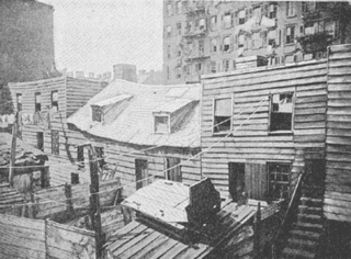
Slum clearance in the United States has been used as an urban renewal strategy to regenerate derelict or run-down districts, often to be replaced with alternative developments or new housing. Early calls were made during the 19th century, although mass slum clearance did not occur until after World War II with the introduction of the Housing Act of 1949 which offered federal subsidies towards redevelopments. The scheme ended in 1974 having driven over 2,000 projects with costs in excess of $50 billion.

Fore Street is a downtown street in Portland, Maine, United States. Dating to 1724, it runs for around 1 mile (1.6 km), from the Eastern Promenade on Munjoy Hill in the northeast to Pleasant Street in the southwest. Near its midsection, Fore Street crosses Franklin Street. It splits briefly at Boothby Square, shortly after passing the United States Custom House. The street passes through the Old Port district.

Middle Street is a downtown street in Portland, Maine, United States. Dating to 1724, it runs for around 0.46 miles (0.74 km), from an intersection with Union Street, Spring Street and Temple Street in the southwest, to Hancock Street, at the foot of Munjoy Hill, in the northeast. It formerly originated at what was then known as Market Square, but 20th-century redevelopment saw the section between Monument Square and Free Street pedestrianized, and the remaining section—around The Maine Lobsterman monument on Temple Street—erased.

India Street is a downtown street and neighborhood in Portland, Maine, United States. Situated near the western foot of Munjoy Hill, it runs for around 0.28 miles (0.45 km), from Congress Street in the northwest to Commercial Street and Thames Street in the southeast. It was the city's first street, and the location of the first settlement of European immigrants to the city in the 17th century. There are thirty handmade bricks in the sidewalk commemorating the neighborhood's notable events. In 1680, when Thomas Danforth was Deputy Governor of the Massachusetts Bay Colony, the street was known as Broad Street. After the incorporation of the Town of Falmouth in 1718, the street was known as High King Street.
References
- 1 2 3 Neighborhood is Maine's most diverse Archived 2008-05-12 at the Wayback Machine in the Portland Press Herald, 3 April 2001
- ↑ "Mapping America: Every City, Every Block". The New York Times. 13 December 2010.
- ↑ "Greater Portland Landmarks' Urban Renewal Roots". Greater Portland Landmarks. 13 May 2020. Retrieved 2022-02-04.
- ↑ "An Overview of PortHousing Authority History". Archived from the original on 2008-05-14. Retrieved 2008-05-27.
- ↑ Randy BillingsStaff Writer (2021-09-25). "Portland may turn down the volume in Bayside amid increasing noise complaints". Press Herald. Retrieved 2022-02-04.
- ↑ Writer, Gillian GrahamStaff (2022-07-05). "In chaotic July 4th scene, a Portland man is shot and a crowd aims fireworks at police who respond". Press Herald. Retrieved 2022-07-06.
43°39′54.1″N70°15′23.0″W / 43.665028°N 70.256389°W
| | This Maine state location article is a stub. You can help Wikipedia by expanding it. |