Sylvan Lake is a town in central Alberta, Canada. It is located 25 kilometres (16 mi) west of the City of Red Deer along Highway 11 or Highway 11A. It is situated on the southeast edge of Sylvan Lake, a 15-kilometre-long (9.3 mi) freshwater lake, in Red Deer County.

Bowness is a neighbourhood and former town in west Calgary, Alberta, Canada. The former town was amalgamated into the City of Calgary in 1964.

Alberta Provincial Highway No. 2, commonly referred to as Highway 2 or the Queen Elizabeth II Highway, is a major highway in Alberta, Canada that stretches from the Canada–United States border through Calgary and Edmonton to Grande Prairie. Running primarily north to south for approximately 1,273 kilometres (791 mi), it is the longest and busiest highway in the province carrying nearly 170,000 vehicles per day in central Calgary. Between Edmonton and Fort Macleod, the highway forms a portion of Alberta's Export Highway and the CANAMEX Corridor. More than half of Alberta's 4 million residents live in the Calgary–Edmonton Corridor created by Highway 2.

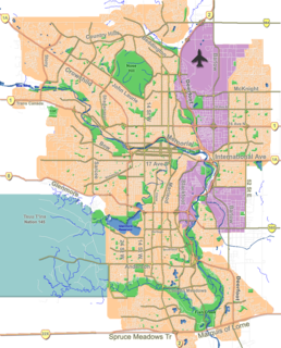
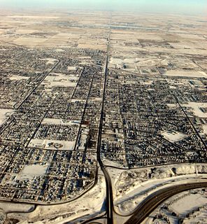
Deerfoot Trail is a 46.4-kilometre (28.8 mi) freeway segment of Highway 2 in Calgary, Alberta, Canada. It stretches the entire length of the city from south to north and links suburbs to downtown via Memorial Drive and 17 Avenue SE. It also forms part of the CANAMEX Corridor which connects Calgary to Edmonton and Interstate 15 in the United States via Highways 3 and 4. The freeway begins south of Calgary where it splits from Macleod Trail, crosses the Bow River into city limits, and reaches the Stoney Trail ring road. Crisscrossing twice more with the river, it intersects Glenmore Trail and Memorial Drive; the former is a major east–west expressway while the latter is a freeway spur into downtown. In north Calgary, it crosses Highway 1 and passes Calgary International Airport before ending at a second interchange with Stoney Trail. Highway 2 becomes the Queen Elizabeth II Highway as it continues north into Rocky View County towards Edmonton.

Alberta Provincial Highway No. 2A is the designation of six alternate routes off Highway 2 in Alberta, Canada. In general, these are original sections of Highway 2, such as the southern portion of Macleod Trail in Calgary. They passed through communities before limited-access freeways were built to shorten driving distance, accommodate heavier volumes and to bypass city traffic. Portions of the alignment of Highway 2A follow the route of the former Calgary and Edmonton Trail.
A range road in Canada is a road that runs north–south along a range grid line of the Dominion Land Survey. Range roads are perpendicular to township roads which run east–west along the township grid lines.

Chestermere, originally named Chestermere Lake, is a city in the Canadian province of Alberta, within Rocky View County. It is largely a commuter town of Calgary and is a member municipality of the Calgary Regional Partnership. The city, which surrounds Chestermere Lake, was known as Chestermere Lake from 1977 to 1993.

Shepard is a former hamlet within the eastern periphery of Calgary, Alberta, Canada, approximately 24 kilometres (15 mi) east of downtown, that was annexed from Rocky View County in July 2007. Shepard is bound by 84 Street SE to the west, a rail line to the north, and 114 Avenue SE to the south. The Stoney Trail ring road passes to the west of the former hamlet. Shepard is immediately north of Ralph Klein Park, a large green space that was developed in the late 2000s.

Alberta Provincial Highway No. 560, commonly referred to as Highway 560 or Glenmore Trail, is a highway in the province of Alberta, Canada. It runs west–east from the east Calgary boundary at 84 Street SE, north along the city boundary to Range Road 284, across Highway 791 south of Chestermere to the southern terminus of the northern section of Highway 797, Centre Street in Langdon.
Barlow Trail is a major arterial road in Calgary, Alberta, Canada that is composed of three parts: the southern section which runs from Deerfoot Trail near 130 Avenue SE to Deerfoot Trail at the intersection with Peigan Trail; the central section which runs from 17 Avenue SE to McCall Way; and the northern section which runs from Airport Road to 128 Avenue NE.
Blackfoot Trail is a road in Calgary, Alberta, Canada. It is named for the Blackfoot Confederacy, and more specifically the Siksika Nation, located east of Calgary. The road runs from 17 Avenue SE in the north, where Blackfoot Trail meets Deerfoot Trail, to Southland Drive in the south. It is the historical alignment of Highway 2 in south Calgary. The section of Blackfoot Trail between 19 Street SE and Deerfoot Trail is a former alignment, and still technically part of, 17 Avenue SE; however, it is generally referred to as being part of Blackfoot Trail.

Albert Park is a former village in Alberta, Canada that is now within the City of Calgary. Its village status ceased after just over a year upon amalgamating with nearby Forest Lawn to the east.

Cityscape is a residential neighbourhood in the northeast quadrant of Calgary, Alberta, Canada. It is bounded by Métis Trail to the west, Country Hills Boulevard to the north, the future 60 Street NE extension to the east, and the future Airport Trail NE extension to the south. Country Hills Boulevard becomes Highway 564 as it exits Calgary to the east.

Hotchkiss is a residential neighbourhood in the southeast quadrant of Calgary, Alberta, Canada. It is bounded by Marquis of Lorne Trail SE (Highway 22X to the south, 88 Street SE to the west, 146 Avenue SE to the north and future Neighbourhood 8 within the South Shepard Area Structure Plan to the east. The future extension of Stoney Trail is to the west beyond 88 Street SE.

16 Avenue N is a major road in Calgary, Alberta, Canada that forms a 26.5-kilometre (16.5 mi) segment of Highway 1 and connects Calgary to Banff and Medicine Hat. It is a four to six-lane principal arterial expressway at its extremities, but is an urban arterial road between the Bow River and Bowness Road, and also between Crowchild Trail and Deerfoot Trail. Due to Calgary's quadrant system, it is known as 16 Avenue NW west of Centre Street and 16 Avenue NE to the east.

17 Avenue SE is a major arterial road in east Calgary, Alberta, Canada. 17 Avenue SE is the focal point of the International Avenue Business Revitalization Zone (BRZ) and the main roadway through the former town of Forest Lawn. Chestermere Boulevard is a major arterial road and the eastern extension of 17 Avenue SE through Chestermere, Alberta, Canada. The roadway is a former alignment of Highway 1A.


