East End Light

Last updated

East End Light
Gorling Bluff Light
EAST END LIGHT - GRAND CAYMAN ISLAND.jpg
East End Light
LocationEast End
Grand Cayman
Cayman Islands
Coordinates 19°18′00″N81°06′00″W / 19.30000°N 81.10000°W / 19.30000; -81.10000 [1]
Tower
Constructed1900 (original tower)
1937 (current tower)
Constructionsteel skeletal tower
Automated1937 (current tower)
Height8 metres (26 ft) [2]
Shapesquare tower with balcony and beacon
Markingswhite tower, black base tower
Operator National Trust for the Cayman Islands
Light
First lit1937 (current tower)
Focal height22 metres (72 ft)
Range12 nautical miles (22 km; 14 mi) [3]
Characteristic Fl (2) W 20s.

The East End Light (sometimes called Gorling Bluff Light) is a lighthouse located at the east end of Grand Cayman island in the Cayman Islands. The lighthouse is the centerpiece of East End Lighthouse Park, managed by the National Trust for the Cayman Islands; the first navigational aid on the site was the first lighthouse in the Cayman Islands. [4]

Contents

History

The east end of Grand Cayman has long been well known for the treacherous reefs which lie under the ocean's surface just off its coast, and was in the past known as the "Graveyard of the Caribbean". [5] The area was the site of the island's most famous shipwreck, the Wreck of the Ten Sail, in 1794; [5] miraculously, only eight lives were lost in the disaster when ten merchant vessels ran aground in rough seas. The area was sparsely inhabited at the time, but local residents banded together with some inhabitants of Bodden Town to assist the crews of the wrecked ships.

Memorial plaque commemorating Wreck of the Ten Sail as dedicated by Queen Elizabeth II in 1994 Memoral Plaque Wreck of the Ten Sail.jpg
Memorial plaque commemorating Wreck of the Ten Sail as dedicated by Queen Elizabeth II in 1994

By the end of the nineteenth century, Eastern Channel in Gun Bay was designated a port of entry for the East End area. Much business was conducted there; the channel was trafficked by ships leaving and arriving on fishing and turtling trips, and by freight- and mail-carrying vessels as well. [5]

The first lighthouse for the East End was erected about a half-mile away from the site of the present tower, being built on Gun Bluff in the early twentieth century. It was one of two lighthouses built on the island; the other was constructed in George Town at about the same time. The structure consisted of a steel [2] ship's mast, 60 feet (18 m) tall, standing on the bluff. William James Watler served as the first keeper, ensuring that a kerosene lantern was hoisted to the top of the mast at 6:00 every evening and bringing it down at 6:00 every morning. A fine "not exceeding forty shillings" would be levied on him should he be derelict in his duties. This first lighthouse was visible from ten miles out at sea. [5]

It was recognized by 1918 that a more substantial lighthouse was needed for the point, and a French engineer named Terrier was appointed to plan the project. Land at Gorling Bluff was leased, and a new structure was built, along with a shed for holding kerosene. The new site was perfect for a lighthouse, commanding as it did a good view of nearby reefs; it was also the highest point in the district. [5] The new structure was a cylindrical steel mast supporting a wooden frame; this held a three-wick kerosene lamp. Two keepers, Austin B. Conolly and Police Officer Captain Elliott Conolly, were appointed to oversee maintenance and lighting of the light. [5] Remnants of this lighthouse may still be seen standing beside the current tower, [2] while its kerosene lamp is now in the Cayman Islands National Museum. [5]

With the completion, in 1935, of the coastal road along Grand Cayman's southern coast, the community around East End ceased to be as isolated as it had traditionally been, and it was no longer used as a port of entry. As a consequence, the old lighthouse was deemed less necessary, as it was easier to access the village by land. The tower remained in use until 1937, when the British government provided five "navigational lights" of modern design to be scattered among the three Cayman Islands. It was required that these were to be erected on Crown Property, so as a consequence Gorling Bluff was acquired by the British government that same year; the light was placed on the bluff by a Mr. Morell, who came from England to perform the job. [5]

The first lights in the new structure were automatic, controlled by the sun, and could be left for up to six months; as a consequence, the employment of light keepers was no longer deemed necessary. As World War II began, it was decided that the site would be worth turning into a lookout post, and guardians of the light were assigned for this purpose. They also served as lookouts until hostilities erupted, at which point the light came under the jurisdiction of local police. Albert Connor remained in charge until the formation, in June 1942, of the islands' Home Guard. [5] The Guard maintained a 24-hour coastal watch along Grand Cayman's coasts, and a four-man team, commanded by a corporal, was stationed at East End. Although they were trained, they were rarely armed, instead using powerful binoculars to scan the area. The men were given a small barracks, containing a bunkroom, kitchen, and outside latrine as quarters, and had a telephone line connecting them directly with the central office in George Town, to which they reported every half-hour. [5]

The East End Light remains an active aid to navigation, being administered for that purpose by the Cayman Islands' Port Authority; today it is powered by solar energy. [5] The Authority has allowed the National Trust for the Cayman Islands to do some work around the structure to make the site more presentable. A stairway of thirty-seven steps has been installed leading to the summit of the bluff, and large amounts of infill and soil have been taken up to create pathways for visitors. Flower beds show examples of various plants which were used as medicines by the Islands' earliest settlers, and a thousand-gallon water tank has been installed to provide irrigation. As of 2006, work on the park was ongoing. [5]

See also

Related Research Articles

<span class="mw-page-title-main">Lighthouse</span> Structure designed to emit light to aid navigation

A lighthouse is a tower, building, or other type of physical structure designed to emit light from a system of lamps and lenses and to serve as a beacon for navigational aid, for maritime pilots at sea or on inland waterways.

<span class="mw-page-title-main">Macquarie Lighthouse</span> Lighthouse in New South Wales, Australia

The Macquarie Lighthouse, also known as South Head Upper Light, is the first, and is the longest serving, lighthouse site in Australia. It is located on Dunbar Head, on Old South Head Road, Vaucluse in the Municipality of Woollahra local government area of New South Wales, Australia. The lighthouse is situated approximately 2 kilometres (1 mi) south of South Head near the entrance to Sydney Harbour. There has been a navigational aid in this vicinity since 1791 and a lighthouse near the present site since 1818. The current heritage-listed lighthouse was completed in 1883. The lighthouse and associated buildings were designed by James Barnet and built from 1881 to 1883.

<span class="mw-page-title-main">Marblehead Light (Ohio)</span> Lighthouse in Ohio, US

Marblehead Lighthouse in Marblehead, Ohio, United States, is the oldest lighthouse in continuous operation on the American side of the Great Lakes. It has guided sailors safely along the rocky shores of Marblehead Peninsula since 1822, and is an active aid to navigation.

<span class="mw-page-title-main">Block Island Southeast Light</span> Lighthouse in Rhode Island, United States

Block Island Southeast Light is a lighthouse located on Mohegan Bluffs at the southeastern corner of Block Island, Rhode Island. It was designated a U.S. National Historic Landmark in 1997 as one of the most architecturally sophisticated lighthouses built in the United States in the 19th century.

<span class="mw-page-title-main">Michigan Island Light</span> Lighthouse

The Michigan Island Lighthouse is a lighthouse operated by the National Park Service and located on Michigan Island on western Lake Superior in the Apostle Islands National Lakeshore.

<span class="mw-page-title-main">St. Augustine Light</span> Lighthouse in Florida, US

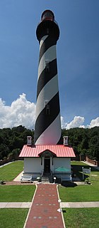
The St. Augustine Light Station is a privately maintained aid to navigation and an active, working lighthouse in St. Augustine, Florida. The current lighthouse stands at the north end of Anastasia Island and was built between 1871 and 1874. The tower is the second lighthouse tower in St. Augustine, the first being lit officially by the American territorial government in May 1824 as Florida's first lighthouse. However, both the Spanish and the British governments operated a major aid to navigation here including a series of wooden watch towers and beacons dating from 1565.

<span class="mw-page-title-main">Cheboygan Crib Light</span> Lighthouse in Michigan, United States

The Cheboygan Crib Light is a light that marks the west pier head of the mouth of the Cheboygan River into Lake Huron. The pier head, in the center of the municipality of Cheboygan, is located at the north or lake end of Huron Street, and is one of the centerpieces of Cheboygan's Gordon Turner Park.

<span class="mw-page-title-main">East Chop Light</span> Lighthouse

East Chop Light is a historic lighthouse standing on a bluff overlooking Vineyard Haven Harbor and Vineyard Sound, located along East Chop Drive in the town of Oak Bluffs, Massachusetts. It is one of five lighthouses located on the island of Martha's Vineyard.

<span class="mw-page-title-main">Haig Point Range Lights</span> Lighthouses in South Carolina, US

The Haig Point Range Lights were range lights on Calibogue Sound at the northeastern end of Daufuskie Island in Beaufort County, South Carolina. The Haig Point Range Lights were built in 1873 and were maintained as an official aid to navigation until about 1924. The Rear Range Light house has been restored. It is a guest house for the Haig Point Club and serves as a private aid to navigation.

<span class="mw-page-title-main">Cove Island Light</span> Lighthouse

The Cove Island Light, at Gig Point on the island, is located in Fathom Five National Marine Park, but is not part of the Park. It is situated on the Bruce Peninsula, Ontario Canada. It has been a navigational aid in the narrow channel between Lake Huron and Georgian Bay since 30 October 1858. It was the first of six stone Imperial Towers to be completed; all were illuminated by 1859. Most other lighthouses of the era were built of brick, wood, iron or concrete.

<span class="mw-page-title-main">Grand Island Harbor Rear Range Light</span> Lighthouse in Michigan, United States

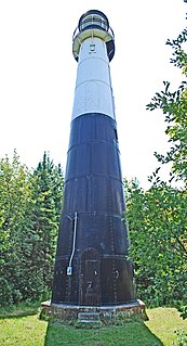
The Grand Island Harbor Rear Range Light is a lighthouse located off M-28 in Munising Township, Michigan. It is also known as the Bay Furnace Rear Range Light, Christmas Rear Range Light, or End of the Road Light. The corresponding front range light was replaced in 1968; the rear range light was listed on the National Register of Historic Places in 1990. It is no longer an active aid to navigation.

<span class="mw-page-title-main">Point Stephens Light</span> Lighthouse in New South Wales, Australia

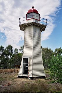
The Point Stephens Light is a heritage-listed active lighthouse located on Point Stephens, a point on an unnamed headland at the east of Fingal Bay, 4.25 km (2.64 mi) south of the entrance of Port Stephens, New South Wales, Australia. The light serves to assist vessels entering Port Stephens. It is considered an endangered lighthouse due to remote location and old age.

<span class="mw-page-title-main">Wadjemup Lighthouse</span> Lighthouse on Rottnest Island, Western Australia

Completed in 1849, the original 20-metre (66 ft) Wadjemup Lighthouse was Western Australia's first stone lighthouse and was built to provide a safer sailing passage for ships to Fremantle Port and the Swan River Colony.

<span class="mw-page-title-main">Low Head Lighthouse</span> Lighthouse in Tasmania, Australia

Low Head Lighthouse is in Low Head, Tasmania, about 7 kilometres (4.3 mi) north of George Town on the east side of the mouth of the Tamar River. It was the third lighthouse to be constructed in Australia, and it is also Australia's oldest continuously used pilot station. This light is now unmanned and automated.

<span class="mw-page-title-main">Double Island Point Light</span> Lighthouse

Double Island Point Light is an active lighthouse located at the summit of Double Island Point, a coastal headland within the Cooloola section of the Great Sandy National Park. It is located at the southern end of Wide Bay, 70 kilometres (43 mi) north of Noosa Heads, Queensland, Australia.

<span class="mw-page-title-main">Pine Islet Light</span> Lighthouse

Pine Islet Light, also known as Percy Isles Light, is an active lighthouse located at Pine Islet, a small islet belonging to the Percy Isles group of the Northumberland Islands, about 130 kilometres (81 mi) southeast of Mackay, Queensland, Australia. The original lighthouse, established 1885, was active for a hundred years, until it was deactivated in 1985, by then the last kerosene powered lighthouse in Australia. It was relocated to the Mackay Marina in 1985 and restored to full working condition, making it the last fully functional kerosene operated lighthouse in the world. At the original location now stands a modern fiberglass tower.

<span class="mw-page-title-main">Low Isles Light</span> Lighthouse

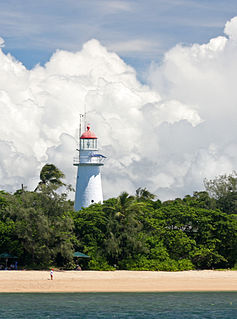
Low Isles Light, also known as Low Islets Light or Low Island Light, is an active lighthouse located on Low Island, a coral cay which together with Woody Island forms the Low Isles group, about 13 kilometres (8.1 mi) northeast of Port Douglas, Queensland, Australia. The island is situated on the western edge of the main shipping channel into the harbour of Port Douglas, and it marks the entrance to the channel. Built in 1878, it was the first lighthouse in Far North Queensland and more specifically the first to light the Inner Passage of the Great Barrier Reef. Its construction is typical to Queensland lighthouses of the time, timber frame clad with galvanized iron, and it is the fourth lighthouse of this type constructed in Queensland, though it is the first of them to use portholes.

<span class="mw-page-title-main">Grand Turk Lighthouse</span> Lighthouse on Grand Turk Island, Turks and Caicos Islands

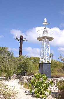
Grand Turk Lighthouse is a lighthouse on Grand Turk Island, Turks and Caicos Islands. The 60-foot-tall (18 m) structure, overlooking North Creek, was completed by British architect Alexander Gordon in 1852 to alert sailors of the shallow reef. Brighter kerosene lamps and a more powerful Fresnel lens were added by the Chance brothers in 1943 and remained in use until 1972 when the lighthouse was electrified. Today, the lighthouse and lighthouse keeper's house are a historic site under the protection of the National Trust.

<span class="mw-page-title-main">Woody Island Lighthouses</span> Historic site in Queensland, Australia

The Woody Island Lighthouses are a pair of heritage-listed lighthouses at Big Woody Island in the Great Sandy Strait, Hervey Bay, Fraser Coast Region, Queensland, Australia. They were built from 1866 to 1870. It was added to the Queensland Heritage Register on 30 March 2001.

<span class="mw-page-title-main">Gannet Rock Lighthouse</span> Lighthouse

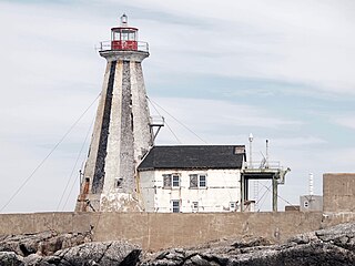
The Gannet Rock Lighthouse is a Canadian lighthouse located on a rocky islet 8 miles (13 km) south of Grand Manan in the Bay of Fundy. It was first lit in 1831 and was staffed until 1996. It was solarized in 2002 and remains operational in 2022. It was declared "surplus to requirements" by the Canadian Coast Guard in 2010 and is no longer being maintained.

References

  1. "Gorling Bluff/East End Light" . Retrieved 17 March 2016.
  2. 1 2 3 Rowlett, Russ. "Lighthouses of the Cayman Islands". The Lighthouse Directory. University of North Carolina at Chapel Hill.
  3. List of Lights, Pub. 110: Greenland, The East Coasts of North and South America (Excluding Continental U.S.A. Except the East Coast of Florida) and the West Indies (PDF). List of Lights . United States National Geospatial-Intelligence Agency. 2016.
  4. "nationaltrust". Archived from the original on 24 March 2016. Retrieved 17 March 2016.
  5. 1 2 3 4 5 6 7 8 9 10 11 12 "nationaltrust". Archived from the original on 9 April 2004. Retrieved 17 March 2016.