
The McKenzie River is a 90-mile (145 km) tributary of the Willamette River in western Oregon in the United States. It drains part of the Cascade Range east of Eugene and flows westward into the southernmost end of the Willamette Valley. It is named for Donald McKenzie, a Scottish Canadian fur trader who explored parts of the Pacific Northwest for the Pacific Fur Company in the early 19th century. As of the 21st century, six large dams have been built on the McKenzie and its tributaries.

Seneca Creek is a 19.6-mile-long (31.5 km) tributary of the North Fork of the South Branch of the Potomac River located entirely within Pendleton County, West Virginia, USA.

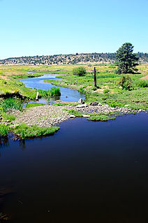
Blue River is a tributary of the McKenzie River in Linn and Lane counties in the U.S. state of Oregon. From its source at the confluence of Mann and Wolf creeks in the Cascade Range, it flows generally southwest to join the McKenzie near the community of Blue River. Saddle Dam and Blue River Dam block the river about 2 miles (3 km) from its mouth to form Blue River Reservoir, a multipurpose impoundment built in 1968 by the United States Army Corps of Engineers.

Muddy Fork is a tributary, about 6 miles (10 km) long, of the Sandy River in the U.S. state of Oregon. Arising at the base of Sandy Glacier on the west slope of Mount Hood, it flows west through the Mount Hood Wilderness in the Mount Hood National Forest. It joins the Sandy River in Old Maid Flat, about 5 miles (8 km) northeast of Rhododendron. The stream offers limited fishing for coastal cutthroat trout.

The South Fork McKenzie River is a tributary, about 31 miles (50 km) long, of the McKenzie River in the U.S. state of Oregon. It begins at about 4,500 feet (1,400 m) above sea level near Mink Lake in the Three Sisters Wilderness of the Cascade Range. Flowing northwest within Lane County, it meets the McKenzie River about 60 miles (97 km) from the larger river's confluence with the Willamette River.

Salt Creek is a tributary, 30 miles (48 km) long, of the Middle Fork Willamette River in Lane County in the U.S. state of Oregon. It is named for salt springs along its banks that are used as licks by deer. The stream originates as an outflow of Lower Betty Lake in the forested Cascade Range just southeast of Waldo Lake. From its source, Salt Creek flows generally south, through Gold Lake, to Route 58, which it then follows mainly northwest for about 26 miles (42 km) to its mouth at the Middle Fork Willamette River just below Hills Creek Dam. At Salt Creek Falls—roughly 4 miles (6.4 km) west of Willamette Pass and a little more than 22 miles (35 km) upstream from the mouth—the stream plunges 286 feet (87 m), discharging an average of 50,000 U.S. gallons (190,000 L) of water per minute, or 111 cubic feet per second (3.1 m3/s). Below the falls, the creek enters a narrow canyon shaped by glaciation and basalt lava flows from higher in the Cascades. McCredie Hot Springs, at the former community of McCredie Springs, are natural hot springs along the lower half of Salt Creek beside Route 58.

French Pete Creek is a tributary of the South Fork McKenzie River in Lane County, in the U.S. state of Oregon. It flows generally west through the Three Sisters Wilderness to the south end of Cougar Reservoir, about 11 miles (18 km) from the larger river's confluence with the McKenzie River. The creek has two named tributaries—Olallie Creek and, further downstream, Pat Creek—both of which enter from the right.

The North Fork Alsea River is a 16-mile (26 km) tributary of the Alsea River in the U.S. state of Oregon. It begins at Klickitat Lake, fed by Klickitat and Lake creeks in the Central Oregon Coast Range, and flows generally south to near Alsea, where it joins the South Fork Alsea River to form the main stem. For most of its course, the North Fork winds through the Siuslaw National Forest in Lincoln County and then Benton County. It passes under Oregon Route 34 northeast of Alsea.
The South Fork Alsea River is a tributary of the Alsea River in the U.S. state of Oregon. It begins at northeast of Horton on the east side of the Central Oregon Coast Range and flows generally northwest to near Alsea. There it joins the North Fork Alsea River to form the main stem.
Smith River is a tributary of the McKenzie River in Linn County in the U.S. state of Oregon. It begins near Browder Ridge in the Cascade Range and flows generally south through the Willamette National Forest to meet the larger river at Trail Bridge Reservoir, about 82 miles (132 km) upstream of the McKenzie's mouth on the Willamette River.
Roaring River is a tributary of the South Fork McKenzie River in Lane County in the U.S. state of Oregon. It begins along the west side of Roaring River Ridge in the Cascade Range and flows generally north through the Willamette National Forest to meet the larger stream about 22 miles (35 km) from its confluence with the McKenzie River.
Beaver Creek is a tributary of the Crooked River in the U.S. state of Oregon. It is formed by the confluence of its two forks in southeastern Crook County, a sparsely populated part of Central Oregon. North Fork Beaver Creek flows south and then west around Laughlin Table. South Fork Beaver Creek drains the slopes of Snow Mountain and Funny Butte in southwestern Grant County before joining the North Fork.
The East Fork Salmon River is a short tributary of the Salmon River in Clackamas County, in the U.S. state of Oregon. It begins on the southern slopes of Mount Hood at an elevation of about 4,300 feet (1,300 m) and flows generally southwest into the main stem at Red Top Meadow, slightly east of Trillium Lake. Its entire course lies within the Mount Hood National Forest. It has no named tributaries.
The South Fork Burnt River is a tributary of the Burnt River in Baker County in the U.S. state of Oregon. Its headwaters lie in the Monument Rock Wilderness and the Wallowa–Whitman National Forest of the Blue Mountains. It flows generally northeast for about to meet the main stem at Unity Reservoir, north of Unity. The river, about 12 miles (19 km) long, crosses under U.S. Route 26 about 3 miles (5 km) northwest of Unity.

The North Fork Umatilla River is a tributary of the Umatilla River in Union and Umatilla counties in the U.S. state of Oregon. Its headwaters lie in the Umatilla National Forest in the Blue Mountains of northeastern Oregon. It flows generally northwest to meet the South Fork Umatilla River near Graves Butte. Together the two forks form the main stem Umatilla.
The Middle Fork Rogue River is a tributary of the South Fork Rogue River in the U.S. state of Oregon. It begins in Klamath County in the Sky Lakes Wilderness of the Cascade Range and flows generally northwest through the Rogue River – Siskiyou National Forest to meet the South Fork south of Prospect. The Middle Fork enters the South Fork about 4 miles (6 km) from the South Fork's confluence with the Rogue River.
The North Fork Smith River is a 34-mile (55 km) tributary of the Smith River in Douglas County in the U.S. state of Oregon. It begins in the Central Oregon Coast Range near Roman Nose Mountain and flows generally southwest to meet the larger river 16 miles (26 km) from its confluence with the Umpqua River at Reedsport. The entire course of the North Fork lies within the Siuslaw National Forest.

The North Fork Smith River is 28-mile (45 km) tributary of the Smith River that begins in the U.S. state of Oregon and ends in the U.S. state of California. Arising near Chetco Peak in the Klamath Mountains, it flows generally south to meet the Middle Fork Smith River at Gasquet, California. The combined streams form the Smith River.
The South Fork Salmon River is a tributary of the Salmon River in Clackamas County in the U.S. state of Oregon. Arising near Plaza Lake, it flows generally northeast along the east side of Salmon Mountain to meet the Salmon 11 miles (18 km) upstream of the larger stream's confluence with the Sandy River at Brightwood.

Horse Creek is a tributary of the McKenzie River in near the unincorporated community of McKenzie Bridge in Lane County in the U.S. state of Oregon. It begins in the Cascade Range in the Three Sisters Wilderness of the Willamette National Forest. Its headwaters are near the Deschutes County border and the Pacific Crest Trail. It flows generally northwest to meet the river about 65 miles (105 km) upstream of the McKenzie's confluence with the Willamette River.
