South Fork McKenzie River

Last updated
South Fork McKenzie River
South Fork McKenzie River, Oregon.jpg
Country United States
State Oregon
County Lane
Sourcenear Mink Lake
 - location Three Sisters Wilderness, Cascade Range
 - elevation4,559 ft (1,390 m) [1]
 - coordinates 43°56′36″N121°55′32″W / 43.94333°N 121.92556°W / 43.94333; -121.92556   [2]
Mouth McKenzie River
 - locationnear Blue River
 - elevation1,093 ft (333 m) [2]
 - coordinates 44°09′32″N122°17′44″W / 44.15889°N 122.29556°W / 44.15889; -122.29556 Coordinates: 44°09′32″N122°17′44″W / 44.15889°N 122.29556°W / 44.15889; -122.29556   [2]
Length31 mi (50 km) [3]
Basin213 sq mi (552 km2) [4]
Dischargefor 0.6 miles (1 km) downstream of Cougar Dam and 3.9 miles (6.3 km) from the mouth
 - average853 cu ft/s (24 m3/s) [5]
 - max17,600 cu ft/s (498 m3/s)
 - min17 cu ft/s (0 m3/s)
USA Oregon location map.svg
Red pog.svg
Location of the mouth of the South Fork McKenzie River in Oregon
Wikimedia Commons: South Fork McKenzie River

The South Fork McKenzie River is a tributary, about 31 miles (50 km) long, of the McKenzie River in the U.S. state of Oregon. It begins at about 4,500 feet (1,400 m) above sea level near Mink Lake in the Three Sisters Wilderness of the Cascade Range. Flowing northwest within Lane County, it meets the McKenzie River about 60 miles (97 km) from the larger river's confluence with the Willamette River. [3] [6]

McKenzie River (Oregon) tributary of the Willamette River in Oregon

The McKenzie River is a 90-mile (145 km) tributary of the Willamette River in western Oregon in the United States. It drains part of the Cascade Range east of Eugene and flows westward into the southernmost end of the Willamette Valley. It is named for Donald McKenzie, a Scottish Canadian fur trader who explored parts of the Pacific Northwest for the Pacific Fur Company in the early 19th century. As of the 21st century, six large dams have been built on the McKenzie and its tributaries.

Oregon State of the United States of America

Oregon is a state in the Pacific Northwest region on the West Coast of the United States. The Columbia River delineates much of Oregon's northern boundary with Washington, while the Snake River delineates much of its eastern boundary with Idaho. The parallel 42° north delineates the southern boundary with California and Nevada. Oregon is one of only three states of the contiguous United States to have a coastline on the Pacific Ocean.

Mink Lake (Lane County, Oregon) lake of the United States of America

Mink Lake is the second-largest wilderness lake in the U.S. state of Oregon. Mink Lake lies at about 5,000 feet (1,500 m) above sea level on a Cascade Range lava plateau in the Three Sisters Wilderness in eastern Lane County. One of many lakes in the Mink Lake Basin, it covers 139 acres (56 ha).

Contents

About 4.5 miles (7.2 km) from the South Fork mouth, [5] Cougar Dam impounds water from the river to create Cougar Reservoir. It is a multipurpose United States Army Corps of Engineers project built in 1963 to generate hydroelectricity and limit flooding. [7]

River mouth end of a river

A river mouth is the part of a river where the river debouches into another river, a lake, a reservoir, a sea, or an ocean.

Cougar Dam

Cougar Dam is a 519-foot (158 m) tall rockfill hydroelectric dam in the U.S. state of Oregon. It has a gated concrete spillway and a powerhouse with two turbines totaling 25 megawatts of electric power.

Cougar Reservoir

Cougar Reservoir is a reservoir on the South Fork McKenzie River in the U.S. state of Oregon. It is in Lane County, 46 miles (74 km) east of Eugene and about 3 miles (5 km) south of the community of Rainbow in the Willamette National Forest. In 1963 the United States Army Corps of Engineers built Cougar Dam on the river primarily to generate hydroelectricity and control flooding, and the reservoir formed behind the dam.

The watershed offers many opportunities for recreation, including fishing, swimming, hiking, and camping. Motorized boating is allowed on Cougar Reservoir, which is used for waterskiing. A popular hot springs is along a tributary near the reservoir. Whitewater enthusiasts sometimes run a difficult stretch of the upper river.

Whitewater bubbly, or aerated and unstable current

Whitewater is formed in a rapid, when a river's gradient increases enough to generate so much turbulence that air is entrained into the water body, that is, it forms a bubbly or aerated and unstable current; the frothy water appears white. The term is also loosely used to refer to less turbulent, but still agitated, flows.

Course

The South Fork McKenzie River begins in the Mink Lake Basin of the Cascade Range at an elevation of about 4,600 feet (1,400 m) above sea level. Lakes near the river's headwaters include Mink, Porky, Mud, Plumb, Goose, and Corner, as well as many smaller water bodies. Flowing west through the Three Sisters Wilderness of the Willamette National Forest, the river receives Elk Creek from the left at river mile (RM) 25 or river kilometer (RK) 40. About 2 miles (3 km) further downstream, the river leaves the wilderness. [3]

Willamette National Forest United States national forest in Oregon

The Willamette National Forest is a National Forest located in the central portion of the Cascade Range of the U.S. state of Oregon. It comprises 1,678,031 acres (6,790.75 km2), making it one of the largest national forests. Over 380,000 acres are designated wilderness which include seven major mountain peaks. There are also several National Wild and Scenic Rivers within the forest. The forest is named for the Willamette River, which has its headwaters in the forest. The forest headquarters are located in the city of Springfield. There are local ranger district offices in McKenzie Bridge, Detroit, Sweet Home, and Westfir.

The river passes Frissel Crossing Campground, which is on the left, about 22 miles (35 km) from the mouth. Slightly downstream of the campground, the South Fork passes under Forest Road  19 (Aufderheide Drive), which then runs parallel to the river along its right bank, and Roaring River enters from the left. Over the next stretch, Fir and Cascade creeks enter from the right. The Homestead Campground is on the right at about RM 18 (RK 29), and here the river turns northwest and then north. Augusta Creek enters from the left about 2 miles (3 km) later at Dutch Oven Campground. [3]

Forest Highways or Forest Routes are a category of roads within United States National Forests. They are built to connect the national forests to the existing state highway systems, and to provide improved access to recreational and logging areas.

Over the next stretch, Starr and Blue creeks enter from the left and Trail and Rebel creeks from the right. Hardy and Balm creeks enter from the left about 12 miles (19 km) from the mouth. Below this, the river reaches French Pete Campground, which is on the right, and receives Horn and Penny creeks from the left before arriving at a United States Geological Survey stream gauge near the mouth of Tipsoo Creek, at about RM 10 (RK 16). Just beyond the gauge, the river enters Cougar Reservoir, receiving Ridge Creek from the left and passing Cougar Crossing Campground, which is on the right. Here the river passes under Forest Road 19, which continues to parallel the South Fork but along its left bank. Shortly thereafter, Smith Creek enters from the right near Sunnyside Campground, and then Slide Creek enters from the right near Slide Creek Campground and its boat ramp. [3]

French Pete Trail

The French Pete Trail is a 9.9-mile (15.9 km) hiking trail in the valley of French Pete Creek in the Three Sisters Wilderness of western Oregon. The trail passes through low-elevation old-growth forest that was a nationwide political issue in the 1960s and 1970s because of conflicting plans for logging and for wilderness designation, respectively. In 1978, the U.S. Congress passed a bill adding the French Pete area to the Three Sisters Wilderness.

United States Geological Survey scientific agency of the United States government

The United States Geological Survey is a scientific agency of the United States government. The scientists of the USGS study the landscape of the United States, its natural resources, and the natural hazards that threaten it. The organization has four major science disciplines, concerning biology, geography, geology, and hydrology. The USGS is a fact-finding research organization with no regulatory responsibility.

Stream gauge locations used to monitor surface water flow

A stream gauge, streamgage or gauging station is a location used by hydrologists or environmental scientists to monitor and test terrestrial bodies of water. Hydrometric measurements of water level surface elevation ("stage") and/or volumetric discharge (flow) are generally taken and observations of biota and water quality may also be made. The location of gauging stations are often found on topographical maps. Some gauging stations are highly automated and may include telemetry capability transmitted to a central data logging facility.

Rider Creek enters from the left at RM 8 (RK 13), and Boone Creek enters from the left a fraction of a mile later. In the next stretch of the reservoir, Annie and Basalt creeks enter from the left and Walker Creek from the right before the river receives the East Fork South Fork McKenzie River from the right about 5 miles (8 km) from the South Fork mouth. A fraction of a mile below this, Rush Creek enters from the left, and the river reaches Cougar Dam and power plant. [3]

Another stream gauge is beyond the dam, at about RM 4 (RK 6). Along this stretch, a county road linking the dam to Oregon Route 126 is on the river's right bank, while Forest Road 19 is on the left. In its last stretch, the river passes again under Forest Road 19, which merges with the dam road. The South Fork turns west and meanders another mile or so, passing the Delta Campground, which is on its right, and entering the McKenzie River main stem about 59.5 miles (95.8 km) from its confluence with the Willamette River. [3]

Recreation

Cougar Dam on the South Fork USACE Cougar Dam South Fork McKenzie River.jpg
Cougar Dam on the South Fork

Fishing, camping, hiking, swimming, and boating are among the forms of recreation pursued in the South Fork McKenzie River watershed. Cougar Reservoir is used for motorized boating, fishing, swimming, and waterskiing. The United States Forest Service maintains three campgroundsCougar Crossing, Slide Creek, and Sunnysidenear the reservoir, with opportunities for hiking and picnicking as well as camping. Other campgrounds in the general vicinity of the reservoir include French Pete and Delta. [8]

Cougar Reservoir supports populations of stocked rainbow trout and stocked landlocked Chinook salmon as well as naturally reproducing cutthroat trout. [9] The lake also supports bull trout, but it is not legal to catch and keep them. [9] Catch-and-release fishing for cutthroat and bull trout is popular on the upper river and its tributaries. [10] Fish on the upper river are numerous but relatively small, averaging 8 to 11 inches (20 to 28 cm). [10]

Terwilliger Hot Springs, near the confluence of Rider Creek and the South Fork, offers six clothing-optional soaking pools in sight of a waterfall and "a spectacular rock formation". [11] The popular hot springs, with a parking lot off Forest Road 19, requires a day-use pass that can be paid for on-site. [11]

Whitewater enthusiasts sometimes run all or part of an 8.5-mile (13.7 km) stretch of the river from above French Pete Campground to Cougar Reservoir. Rapids vary from class 3 to 5 on the International Scale of River Difficulty. [12]

See also

Related Research Articles

Tualatin River river in the United States of America

The Tualatin River is a tributary of the Willamette River in Oregon in the United States. The river is about 83 miles (134 km) long, and it drains a fertile farming region called the Tualatin Valley southwest and west of Portland at the northwest corner of the Willamette Valley. There are approximately 500,000 people residing on 15 percent of the land in the river's watershed.

Clackamas River tributary of the Willamette River in Oregon

The Clackamas River is an approximately 83-mile (134 km) tributary of the Willamette River in northwestern Oregon, in the United States. Draining an area of about 940 square miles (2,435 km2), the Clackamas flows through mostly forested and rugged mountainous terrain in its upper reaches, and passes agricultural and urban areas in its lower third. The river rises in eastern Marion County, about 55 miles (89 km) east-southeast of Salem. The headwaters are on the slopes of Olallie Butte in the Mount Hood National Forest, about 10 miles (16 km) north of Mount Jefferson, at an elevation of 4,909 feet (1,496 m) in the Cascade Range. The Clackamas flows briefly north and then flows northwest through the mountains, passing through North Fork Reservoir and Estacada. It then emerges from the mountains southeast of Portland. It joins the Willamette near Oregon City and forms the boundary between Oregon City and Gladstone.

Elk River (Oregon) river in southwestern Oregon in the United States

The Elk River is in southwestern Oregon in the United States. About 29 miles (47 km) long, the river drains a remote 92-square-mile (240 km2) area of the Coast Range into the Pacific Ocean.

Big River (Oregon)

The Big River is a tributary of the Coast Fork Willamette River, approximately 12 miles (19 km) long, in western Oregon in the United States. It drains an area of the Calapooya Mountains south of Eugene.

Collawash River river in the United States of America

The Collawash River is a 12-mile (19 km) tributary of the Clackamas River in the U.S. state of Oregon. Formed by the confluence of Elk Lake Creek and the East Fork Collawash River in the Cascade Range, it flows generally north-northwest from source to mouth through the Mount Hood National Forest. The largest tributary of the upper Clackamas, it provides about a third of bigger river's low-flow volume. About 35 percent of its watershed of 150 square miles (390 km2) is protected as wilderness.

Imnaha River tributary of the Snake River in Oregon

The Imnaha River is a 73.3-mile-long (118.0 km) tributary of the Snake River in the U.S. state of Oregon. Flowing generally east near the headwaters and then north through Wallowa County, the entire river is designated Wild and Scenic. It follows a geologic fault to the Snake River, and in addition to land in the Wallowa–Whitman National Forest and private land, its corridor includes parts of three special management areas: the Eagle Cap Wilderness, Hells Canyon National Recreation Area, and Hells Canyon Scenic Byway. The Imnaha flows by the unincorporated community of Imnaha, the only settlement along its course, and enters the Snake River roughly 4 miles (6 km) from the larger river's confluence with the Salmon River of Idaho and 192 miles (309 km) from its confluence with the Columbia River.

Umatilla River tributary of the Columbia River in Oregon

The Umatilla River is an 89-mile (143 km) tributary of the Columbia River in the U.S. state of Oregon. Draining a basin of 2,450 square miles (6,300 km2), it enters the Columbia near the city of Umatilla in the northeastern part of the state. In downstream order, beginning at the headwaters, major tributaries of the Umatilla River are the North Fork Umatilla River and the South Fork Umatilla River, then Meacham, McKay, Birch, and Butter creeks.

Row River river in the United States of America

The Row River is a river, approximately 20 miles (32 km) long, in Lane County, Oregon, United States. It rises in the Cascade Range and flows into the Coast Fork Willamette River near Cottage Grove. The stream was originally known as the "East Fork Coast Fork", but was later renamed after a dispute (row) between neighbors and brothers-in-law George Clark and Joseph Southwell over "trespassing" livestock. Clark was killed as a result of the row. The name rhymes with "cow" rather than with "slow". A post office named Row River operated from 1911 to 1914 a little north of the present site of Dorena at 43.740123°N 122.880347°W.

Mill Creek (Marion County, Oregon) tributary of the Willamette River draining parts of Marion County, Oregon, USA

Mill Creek is a 26-mile (42 km) tributary of the Willamette River that drains a 111-square-mile (290 km2) area of Marion County in the U.S. state of Oregon. Flowing generally west from its source south of Silver Falls State Park, it passes through the cities of Aumsville, Stayton, Sublimity, and Turner before emptying into the Willamette in Salem.

Quartzville Creek tributary of the Middle Santiam River in Oregon

Quartzville Creek is a 28-mile (45 km) tributary of the Middle Santiam River in Linn County in the U.S. state of Oregon. It is paralleled by the Quartzville Back Country Byway and used for recreation, including camping, fishing, hunting, kayaking, and gold panning. The lower 12 miles (19 km) of the creek, from the Willamette National Forest boundary to Green Peter Reservoir, was designated Wild and Scenic in 1988.

Blue River (Oregon) tributary of the McKenzie River in Linn and Lane counties in the U.S. state of Oregon

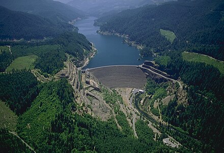
Blue River is a tributary of the McKenzie River in Linn and Lane counties in the U.S. state of Oregon. From its source at the confluence of Mann and Wolf creeks in the Cascade Range, it flows generally southwest to join the McKenzie near the community of Blue River. Saddle Dam and Blue River Dam block the river about 2 miles (3 km) from its mouth to form Blue River Reservoir, a multipurpose impoundment built in 1968 by the United States Army Corps of Engineers.

Course of the Rogue River (Oregon) river in the United States of America

The Rogue River in the U.S. state of Oregon begins at Boundary Springs on the border between Klamath and Douglas counties near the northern edge of Crater Lake National Park. The Rogue River flows generally west for 215 miles (346 km) from the Cascade Range through the Rogue River – Siskiyou National Forest and the Klamath Mountains to the Pacific Ocean at Gold Beach. Communities along its course include Union Creek, Prospect, Trail, Shady Cove, Gold Hill, and Rogue River, all in Jackson County; Grants Pass, and Galice in Josephine County, and Agness, Wedderburn and Gold Beach in Curry County. Significant tributaries include the South Fork Rogue River, Elk Creek, Bear Creek, the Applegate River, and the Illinois River. Arising at 5,320 feet (1,622 m) above sea level, the river loses more than 1 mile (1.6 km) in elevation by the time it reaches the Pacific.

South Fork Rogue River tributary of the Rogue River in Oregon

The South Fork Rogue River is a 25-mile (40 km) tributary of the Rogue River in the U.S. state of Oregon. Rising in the Sky Lakes Wilderness in the Cascade Range, it flows generally northeast through the Rogue River – Siskiyou National Forest to meet the Rogue River downstream of Prospect and slightly upstream of Lost Creek Lake.

Course of the Willamette River

The Willamette River is a 187-mile (301 km) tributary of the Columbia River in the U.S. state of Oregon. The upper tributaries of the Willamette originate in mountains south and southeast of Eugene and Springfield. Formed by the confluence of the Middle Fork Willamette River and Coast Fork Willamette River near Springfield, the main stem meanders generally north from source to mouth. The river's two most significant course deviations occur at Newberg, where the stream turns sharply east, and about 18 miles (29 km) downriver from Newberg, where it turns north again. Near its mouth, the river splits into two channels that flow around Sauvie Island. The main channel enters the Columbia about 101 miles (163 km) from the larger stream's mouth on the Pacific Ocean, and the smaller Multnomah Channel enters the Columbia about 14.5 miles (23.3 km) further downstream near St. Helens in Columbia County.

Blue River Reservoir

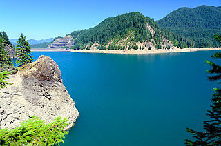
Blue River Reservoir is an artificial impoundment, about 6 miles (10 km) long, of the Blue River in Lane County in the U.S. state of Oregon. The reservoir is about 1 mile (1.6 km) north of Oregon Route 126 in the Willamette National Forest about 45 miles (72 km) east of Eugene.

West Fork Millicoma River river in the United States of America

The West Fork Millicoma River is a tributary, about 34 miles (55 km) long, of the Millicoma River in the U.S. state of Oregon. Rising in northeastern Coos County near the Douglas County line, it flows generally southwest through the Elliott State Forest of the Southern Oregon Coast Range to the community of Allegany. There it joins the East Fork Millicoma River to form the Millicoma. In turn, the Millicoma, which is only about 9 miles (14 km) long, joins the South Fork Coos River to form the Coos River. The Coos River, itself only about 5 miles (8 km) long, empties into the eastern end of Coos Bay, which connects to the Pacific Ocean.

South Fork Coos River river in the United States of America

The South Fork Coos River is a tributary, about 32 miles (51 km) long, of the Coos River in the U.S. state of Oregon. Formed by the confluence of the Williams River and Tioga Creek, it begins in eastern Coos County near the Douglas County line and flows generally northwest through the Southern Oregon Coast Range. East of the city of Coos Bay, it joins the Millicoma River to form the Coos River. This larger river, only about 5 miles (8 km) long, empties into the eastern end of Coos Bay, which connects to the Pacific Ocean.

Smith River (McKenzie River tributary)

Smith River is a tributary of the McKenzie River in Linn County in the U.S. state of Oregon. It begins near Browder Ridge in the Cascade Range and flows generally south through the Willamette National Forest to meet the larger river at Trail Bridge Reservoir, about 82 miles (132 km) upstream of the McKenzie's mouth on the Willamette River.

References

  1. Source elevation derived from Google Earth search using GNIS source coordinates.
  2. 1 2 3 "South Fork McKenzie River". Geographic Names Information System (GNIS). United States Geological Survey. November 28, 1980. Retrieved December 24, 2012.
  3. 1 2 3 4 5 6 7 United States Geological Survey (USGS). "United States Geological Survey Topographic Map". TopoQuest. Retrieved December 23, 2012. Map quadrangles show river mileage for the first 25 miles (40 km) of the South Fork. The remaining distance is an estimate based on map scale and ruler. The relevant quadrangles are, from mouth to source, Blue River, McKenzie Bridge, Cougar Reservoir, Grasshopper Mountain, Chucksney Mountain, and Packsaddle Mountain.
  4. "Willamette Basin TMDL: McKenzie Subbasin" (PDF). Oregon Department of Environmental Quality. p. 6. Retrieved December 24, 2012.
  5. 1 2 "Water-Data Report 2011: 14159500 South Fork McKenzie River near Rainbow, OR" (PDF). United States Geological Survey. Retrieved December 24, 2012.
  6. United States Geological Survey (USGS). "United States Geological Survey Topographic Map". TopoQuest. Retrieved December 23, 2012. Map quadrangles show river mileage for the entire length of the McKenzie River.
  7. Johnson, Daniel M.; Petersen, Richard R.; Lycan, D. Richard; Sweet, James W.; Neuhaus, Mark E., and Schaedel, Andrew L. (1985). Atlas of Oregon Lakes. Corvallis: Oregon State University Press. p. 178. ISBN   0-87071-343-4.
  8. "Cougar Reservoir Area". U.S. Forest Service. Retrieved December 25, 2012.
  9. 1 2 Sheehan, Madelynne Diness (2005). Fishing in Oregon: The Complete Oregon Fishing Guide (10th ed.). Scappoose, Oregon: Flying Pencil Publications. p. 128. ISBN   0-916473-15-5.
  10. 1 2 Sheehan, p. 153
  11. 1 2 "Terwilliger Hot Springs". U.S. Forest Service. Retrieved December 25, 2012.
  12. Giordano, Pete. Soggy Sneakers: A Paddler's Guide to Oregon's Rivers (4th ed.). Seattle: The Mountaineers Books. pp. 148–150. ISBN   978-0-89886-815-9.